
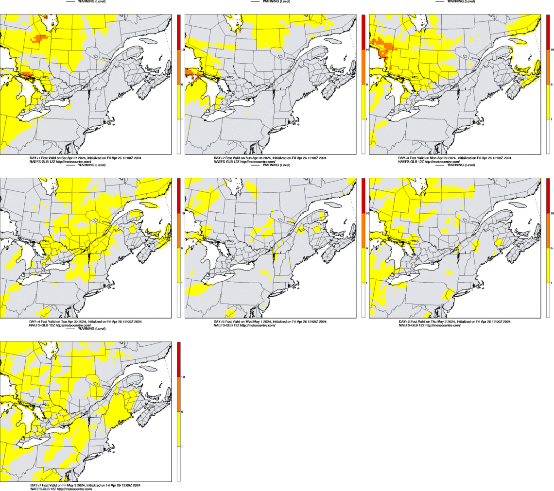
The approach of WeatherAlert-ForecastWeatherAlert-Forecast is an automated warning system for Southern Quebec based on the North-American Ensemble Forecasting System (NAEFS). The approach follow the MOGREPS-Warning system develop at the UK Met Office to assist the forecasters in the issuance of weather warnings. Warnings, ranging from 0 to 10 (where 10 is the highest level), are based on the likelihoods of weather events occurring and their impact on peoples' day-to-day activities if they do occur. Weather events and their impact degree (low, medium or high) are based on a priori defined threshold values for various weather parameters. The likelihood of each impact level for each parameters is calculated from the NAEFS forecasts. Likelihoods are transformed into a warning level according to the following matrix. 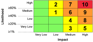 A warning level is found for each weather parameters. The highest level reach among all the parameters determined the final warning level. Warning levels 1 to 5 are colored in yellow, 6 to 9 in orange and 10 in red. The following table show the 6 parameters currently taken into account as well as their threshold values. The threshold values follow, in part, the public weather warning criterion used by Environment Canada for continental Southern Quebec. Currently, the same threshold values are used over all the domain of WeatherAlert-Quebec. Maps of North America are shown only to allow the comparison of Southern Quebec's weather with the rest of the continent.
* For thunderstorm risks, the probabilities to exceed CAPE (Convective Available Potential Energy) and EHI (Energy Helicity Index) thresholds are multiply by the precipitation probabilities to hide unstable areas where triggering mecanisms are lacking. Warning: The information on WeatherAlert-Forecast is not guaranteed to be up-to-date and is prone to large errors. Never use for important decision making. Please always refer to Environment Canada's public forecasts and warnings. UQAM decline any responsibility for the usage of these data. |
|||||||||||||||||||||||||||||||||||||||||||||||||||||||||
Last update : 29 December 2022
ATTENTION Downloading of any data from this server implies that you accept that the use of this data is only for personal, research or educational purposes. Do not use for flight planning purposes. UQAM declines any responsibility for the usage of these data.
Many of these pages made possible by data and software (GEMPAK, McIDAS, LDM) from the Unidata Program. Unidata is sponsored by the National Science Foundation.
![]()