MissRachou
-
Compteur de contenus
88 -
Inscription
-
Dernière visite
-
Jours gagnés
2
Visiteurs récents du profil

MissRachou's Achievements
")


-

Observations du 5 au 11 août 2024
MissRachou a répondu à un(e) topic de beachcp31 dans Discussions générales
St-Mathieu du Parc ce matin (Duché de Bicolline, photo d une amie) On espère que ça descende d'ici demain
-
Observations du 5 au 11 août 2024
MissRachou a répondu à un(e) topic de beachcp31 dans Discussions générales
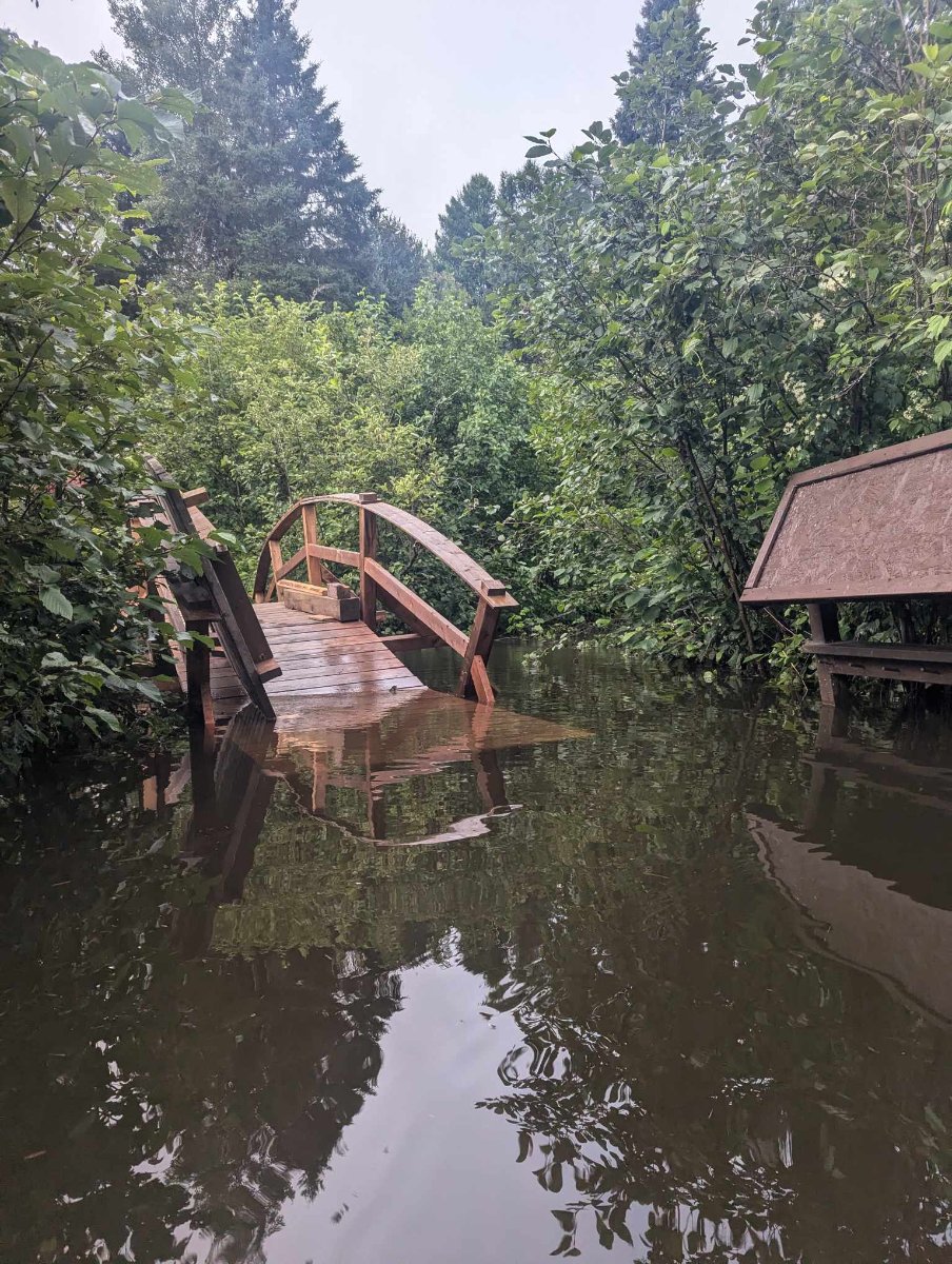
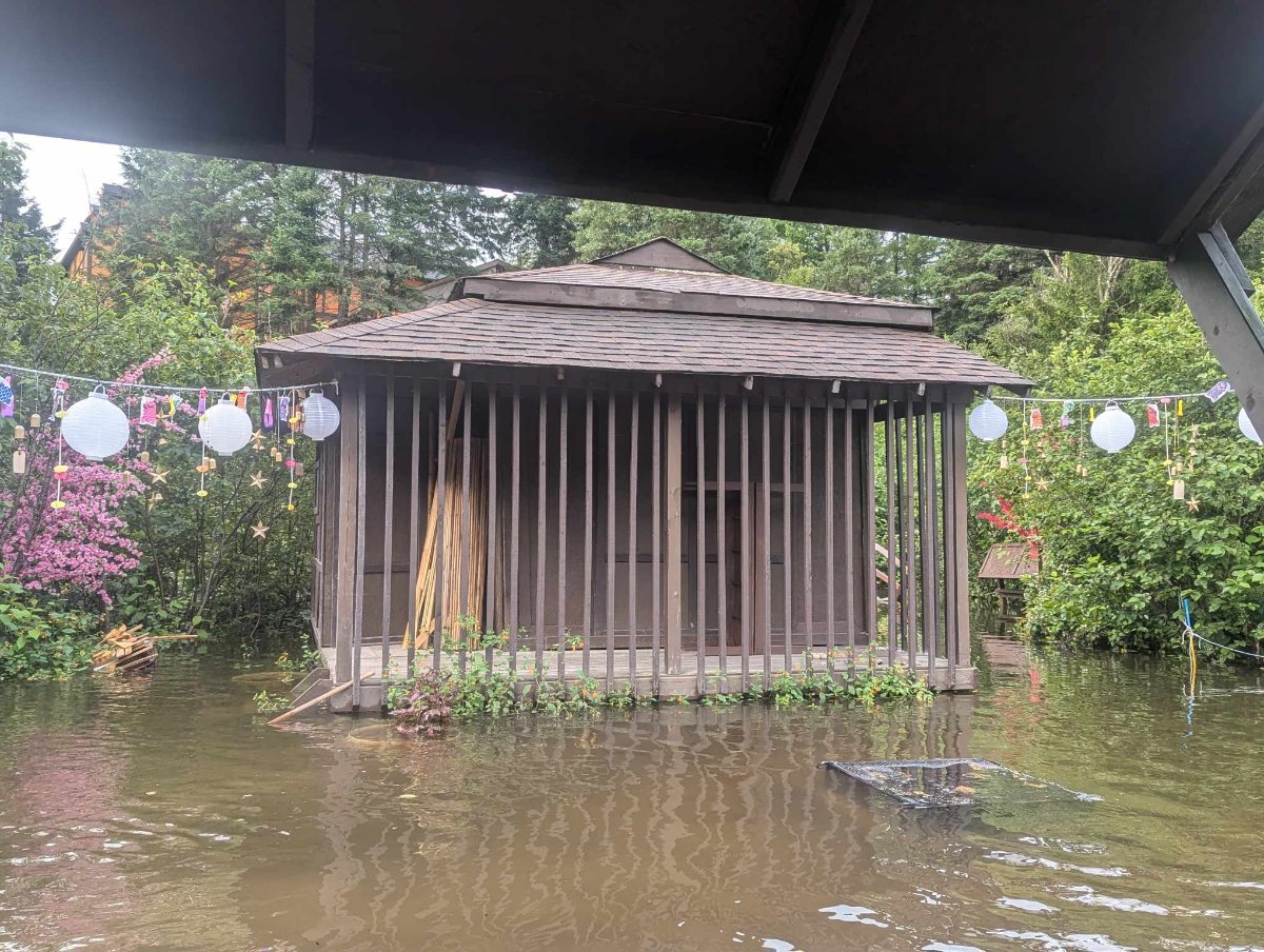
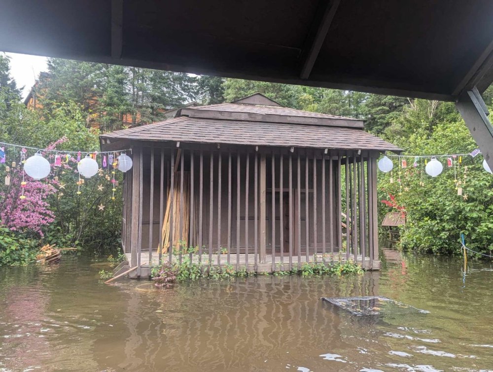
Lorraine, j'ai enregistré 140mm d'eau. à 18h j'étais à 55.63 et à 20h 140.7 mm. Plusieurs concitoyens ont eu de l'eau dans leurs sous-sol. Je pars pour la Mauricie demain am, je surveille le niveau de la rivière Shawinigan . Au moins ce matin la tendance est à la baisse -
Orages violents du 21 mai 2022
MissRachou a répondu à un(e) topic de EricB dans Discussions générales
Ici ça pas été trop pire. Beaucoup de vent soudain. Pas de dommage chez moi. Possiblement des arbres abîmer dans mon secteur J aimerais savoir si quelqu'un connaît la situation dans le coin de Brownsburg. J ai un ami qui habite au fond du chemin de la carrière et le message que j ai eu c est que le chemin est totalement impraticable. Pour reprendre son expression: on dirait qu'un géant a passé la tondeuse sur le bord du chemin. Évidemment il n a pas d électricité alors je n ai pas moyen d en savoir plus. Merci d avance -
Quelle bête ! Heureusement elle a enfin rétrogradée. Sur le plan humain il y a des endroits ou ça sera terrible. https://wgno.com/news/louisiana/jefferson-parish/lafitte-mayor-pleas-for-help-as-hurricane-ida-devastates-area/ https://www.wwltv.com/article/weather/ochsner-medical-center-hurricane-ida/289-f4ebe2ec-3eb9-4b23-ba35-d088d9ce0396
-
Observations du 19 au 25 juil. 2021
MissRachou a répondu à un(e) topic de beachcp31 dans Discussions générales
Oui le feux en Ontario. La qualité de l'air n est pas très bonne. Avertissement de smog et avec l'humidité hier Pm c'était pas plaisant pour moi -
Hypothèse pourquoi les gens désertent ce magnifique forum
MissRachou a répondu à un(e) topic de EricB dans Discussions générales
L'été je suis pas mal occupée ! Je prends soins du potager / des enfants et j'ai quand même beaucoup de boulot! Donc moins de temps devant un écran! Mine de rien je vous lis de temps en temps. -
Observations du 21 au 27 juin 2021
MissRachou a répondu à un(e) topic de beachcp31 dans Discussions générales
Soutien Pas trop loin j ai vue que c'était une EF2 sur Mascouche De mon côté j ai vue beaucoup de vidéos où les gens étaient dans des situations a risque, j essai de faire de la sensibilisation -
Observations du 21 au 27 juin 2021
MissRachou a répondu à un(e) topic de beachcp31 dans Discussions générales
https://www.facebook.com/546016274/posts/10158621462091275/ Je ne sais pas si le lien va fonctionner mais je suis tombé la dessus tantôt (mascouche) -
Observations du 31 mai au 6 juin 2021
MissRachou a répondu à un(e) topic de beachcp31 dans Discussions générales
Basses Laurentides. Ce Matin nous avions du vent. Une première petite pluie de 16h20 pour environ une quinzaine de minutes. Là c est le calme plat tout comme je reçoit l alerte d orage. Ça commence à être sombre -
tu as raison on est a un cat 4 ! ...ETA BECOMES A CATEGORY 4 HURRICANE AS CONDITIONS BEGIN TO DETERIORATE ALONG THE NORTHEASTERN COAST OF NICARAGUA... ...LIFE-THREATENING STORM SURGE, CATASTROPHIC WINDS, FLASH FLOODING, AND LANDSLIDES EXPECTED ACROSS PORTIONS OF CENTRAL AMERICA... A Hurricane Warning continues for the coast of Nicaragua from the Honduras / Nicaragua border to Sandy Bay Sirpi. Catastrophic wind damage is expected where Eta's eyewall moves onshore within the Hurricane Warning area beginning tonight, with tropical storm conditions beginning within the next few hours. Preparations to protect life and property should be rushed to completion. A Tropical Storm Warning and Hurricane Watch continues for the northeastern coast of Honduras from Punta Patuca to the Honduras / Nicaragua border. Tropical storm conditions are expected there tonight, with hurricane conditions possible in by early Tuesday. A Tropical Storm Watch is in effect for the northern coast of Honduras from west of Punta Patuca westward to Punta Castilla. Tropical Storm conditions are possible there by early Tuesday. A dangerous storm surge will raise water levels by as much as 12 to 18 feet above normal tide levels in areas of onshore winds along the coast of Nicaragua within the hurricane warning area, and 3 to 5 feet above normal tide levels along the coast of Honduras within the tropical storm warning area. Near the coast, the surge will be accompanied by large and destructive waves. Interests elsewhere in Nicaragua and Honduras should monitor the progress of this system. For storm information specific to your area, please monitor products issued by your national meteorological service. At 4 p.m. EST, the eye of Hurricane Eta was located over the Caribbean Sea about 70 miles (110 km) east-southeast of Cabo Gracias A Dios on the Honduras / Nicaragua border and about 80 miles (130 km) east-northeast of Puerto Cabezas, Nicaragua. Eta is moving toward the west-southwest near 9 mph (15 km/h), and this general motion is expected to continue through early Tuesday. A slower westward or west-northwestward motion is forecast to begin on Tuesday and continue through Thursday. On the forecast track, the center of Eta is expected to make landfall along the coast of Nicaragua within the Hurricane Warning area tonight or early Tuesday. The center of Eta is forecast to move farther inland over northern Nicaragua through Wednesday night, and then move across central portions of Honduras on Thursday. Maximum sustained winds have increased to near 130 mph (215 km/h) with higher gusts - a category 4 hurricane on the Saffir- Simpson Hurricane Wind Scale. Hurricane-force winds extend outward up to 25 miles (35 km) from the center and tropical-storm-force winds extend outward up to 125 miles (205 km). Additional strengthening is forecast to occur until Eta reaches the coast of Nicaragua. Weakening will begin after the system moves inland. Eta is expected to produce the following rainfall amounts through Friday evening: - Much of Nicaragua and Honduras: 15 to 25 inches (380 to 635 mm), isolated amounts of 35 inches (890 mm). - Eastern Guatemala and Belize: 10 to 20 inches (255 to 510 mm), isolated amounts of 25 inches (635 mm). - Portions of Panama and Costa Rica: 10 to 15 inches (255 to 380 mm), isolated amounts of 25 inches (635 mm). - Jamaica and southeast Mexico: 5 to 10 inches (125 to 255 mm), isolated amounts of 15 inches (380 mm) over southern areas. - El Salvador, Southern Haiti, and the Cayman Islands: 3 to 5 inches (75 to 125 mm), isolated amounts of 10 inches (255 mm). This rainfall will lead to catastrophic, life-threatening flash flooding and river flooding, along with landslides in areas of higher terrain of Central America. Flash flooding and river flooding are also possible across Jamaica, southeast Mexico, El Salvador, southern Haiti, and the Cayman Islands. The next complete advisory will be issued by NHC at 10 p.m. EST with an intermediate advisory at 7 p.m. EST - www.hurricanes.gov
-
Observations du 5 au 11 oct 2020
MissRachou a répondu à un(e) topic de beachcp31 dans Discussions générales
un ami a Prévost a reçu des grêlons de bonne dimension! j'attends de voir ce qu'il va tomber ici https://imgur.com/a/wfQEkc1 -
Observations du 21 au 27 sep 2020
MissRachou a répondu à un(e) topic de beachcp31 dans Discussions générales
un petit 1 a 8h ce matin .. -
j'ai vue un vidéo sur Facebook de Reed Timmer a Holly beach avec l'eau qui commence déjà a monter C'est assez impressionnant. https://www.facebook.com/166805519168/posts/10158702779269169/?extid=r4U5ruBHoUoPlxXo&d=null&vh=e
-
Tempête tropicale Isaias au Québec!!!
MissRachou a répondu à un(e) topic de EricB dans Discussions générales
Pour l'instant c:est oak island qui va avoir le gros.le landfall est imminent en Cat1 Je ne detesterais pas avoir un petit bout de tempête jusqu'ici ! -
Observations du 27 jui au 2 aoû 2020
MissRachou a répondu à un(e) topic de beachcp31 dans Discussions générales
https://ici.radio-canada.ca/nouvelle/1724083/tornades-ontario-ottawa-dommages-environnement-canada-meteo Ça a brassé fort aussi côté Ontarien! Ici Petits orage et deux grosse vague de pluie forte