Jean-Seb
-
Compteur de contenus
2 127 -
Inscription
-
Dernière visite
-
Jours gagnés
6
Type de contenu
Profils
Forums
Events
Gallery
Tout ce qui a été posté par Jean-Seb
-
Observations système 26-27-28 février
Jean-Seb a répondu à un(e) topic de jeff0411 dans Discussions générales
à mirabel il est tombé environ 5 cm en 24 heure... Ce matin les vents étais très calme , 0 poudrerie dans ca ! Metton que y se sont pas mal toute trompé sur celle la loll -
Observations système 26-27-28 février
Jean-Seb a répondu à un(e) topic de jeff0411 dans Discussions générales
Le retour de st-eustache à mirabel fut pénible... route 148 glacé tout le long avec poudrerie !! Présentement à mirabel il neige avec un bon rythme. Il y avais 3 cm de tombé vers 6h pm -
DISCUSSION TEMPETE POTENTIELLE 26-27 FÉV. 2008
Jean-Seb a répondu à un(e) topic de Pierre dans Discussions générales
Et voila , avertissement de neige abondante pour montréal ! -
Observations système 26-27-28 février
Jean-Seb a répondu à un(e) topic de jeff0411 dans Discussions générales
Environ 2cm à mirabel et st-eustache aussi... ca tombe tout doucement -
DISCUSSION TEMPETE POTENTIELLE 26-27 FÉV. 2008
Jean-Seb a répondu à un(e) topic de Pierre dans Discussions générales
comme mentionné plus haut , meme 15-20 cm avec des bon vents c'est quand meme une bonne tempête... Dans mon cas je circule beaucoup sur la 158 et la 148 ... des qu'il vente un peu c'est épouventable la poudrerie on vois absolument rien ! MM y va avec 10 cm jusqu'a demain soir en plus de ce qui tomberas dans la nuit et un 5 cm additionnel mercredi... je crois fortement a un 20 cm sur montréal et alentours Edit : Intellicast , quoi que pas trop fiable coté neige , y va avec 5-7 pouces juste pour mardi pour mirabel et montréal ... -
DISCUSSION TEMPETE POTENTIELLE 26-27 FÉV. 2008
Jean-Seb a répondu à un(e) topic de Pierre dans Discussions générales
Ce que je trouve dommage c'est de mal informer la population... Il me semble que c'est évident qu'il va pas faire beau demain pi mercredi , on s'entend tous la dessus . Ec a meme mis un buletin météo spécial a se sujet.. mais quel poste de tv, radio en font mention.... probablement proche de 0 ! Avec une prévision de "neige 2-4 cm" 99% du monde vont dire : Haille ya rien la y va rien tombé genre ... Et finallement mercredi matin y vont se levé et dire : sont tu pourri la météo y donnais 2cm pi y'en a 20 !! Ca m'enrage du monde de meme... En tk ... Pour en revenir au sujet je crois à 20 cm pour montréal et alentours . -
DISCUSSION TEMPETE POTENTIELLE 26-27 FÉV. 2008
Jean-Seb a répondu à un(e) topic de Pierre dans Discussions générales
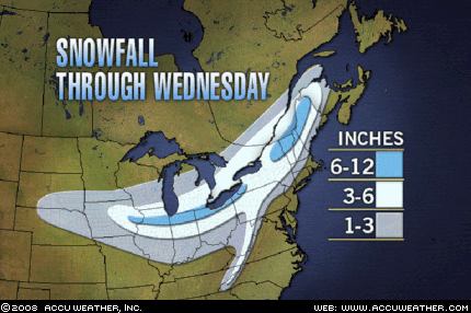
Nouvelle carte de ACW .... Le 3-6 pouces est pas mal plus au nord qu'avant !
-
DISCUSSION TEMPETE POTENTIELLE 26-27 FÉV. 2008
Jean-Seb a répondu à un(e) topic de Pierre dans Discussions générales
Ec avec fais pitié ... 2-4 cm !! -
DISCUSSION ÉVÉNEMENTS DU 2 MARS AU 10 MARS
Jean-Seb a répondu à un(e) topic de Pierre dans Discussions générales
C'est exactement pour ca que j'ai écrit en dessous "Dommage que ya à peu pres 2 % des chances que ca se réalise ahaha!" Je suis pas mal tout sauf confiant que sa se réalise -
DISCUSSION ÉVÉNEMENTS DU 2 MARS AU 10 MARS
Jean-Seb a répondu à un(e) topic de Pierre dans Discussions générales
Avez vous vus ca pour 5-6 mars... selon le dernier météogramme du gfs , 50 cm de neige Dommage que ya à peu pres 2 % des chances que ca se réalise ahaha! Pour le 27-28 février encore un 20-25 cm de possible Cé pas finis l'hivers , hooo non ! -
DISCUSSION ÉVÉNEMENTS DU 19 AU 24 FÉVRIER 2008
Jean-Seb a répondu à un(e) topic de Pierre dans Discussions générales
Selon le météogramme , 3cm avec de la chance :P -
Observations 17 et 18 février 2008.
Jean-Seb a répondu à un(e) topic de Invite01 dans Discussions générales
C'étais fou raide sur les chemins de campagne à matin ... visibilité de 100 metres dans la poudrerie forte ! J'arrive à st-eustache pi y fais soleil , méchant contraste lol -
Observations 17 et 18 février 2008.
Jean-Seb a répondu à un(e) topic de Invite01 dans Discussions générales
Ma dire comme frankie , au moin 5 cm a mirabel pi ca tombe en maudit ! Ca vraiment l'air d'une tempete et selon le radar cé loin d'etre finis! Méchante belle surprise a matin -
Observations 17 et 18 février 2008.
Jean-Seb a répondu à un(e) topic de Invite01 dans Discussions générales
Il détecte du verglas à l'aéroport de mirabel (3 km au sud de chez nous ) et ici il neige encore !! -
Observations 17 et 18 février 2008.
Jean-Seb a répondu à un(e) topic de Invite01 dans Discussions générales
15:30 il neige à mirabel !! Ca va surement virer en verglas bientot ... beark ! -
DISCUSSION SYSTÈME DU 17 ET 18 FÉVRIER 08
Jean-Seb a répondu à un(e) topic de Pierre dans Discussions générales
Pour les reveurs qui s'accrochent à un dernier espoir , intellicast ne donne que de la neige pour mirabel :P J'pense qui vont s'tromper ahahah ! -
DISCUSSION SYSTÈME DU 17 ET 18 FÉVRIER 08
Jean-Seb a répondu à un(e) topic de Pierre dans Discussions générales
Bin cé une bonne nouvelle ! Mais partit comme c'est la , montréal aurais pas beaucoup de précipitation , meme pas 10 mm selon le dernier gfs ! Pas trop épeurant comme tempete -
Mirabel , pres de 10 cm ce matin , J'étais vraiment surpris je m'attendais pas d'en avoir autant !
-
pour participer un peu ... neige a mirabel !!
-
DISCUSSION SYSTÈME DU 17 ET 18 FÉVRIER 08
Jean-Seb a répondu à un(e) topic de Pierre dans Discussions générales
Selon le météogramme montréal aurais seulement 20 mm d'équivalent en eau et a peu pres pas de neige avant... On est encore loin ... j'ai hate de voir les nouveaux modeles demain ! -
DISCUSSION ÉVÉNEMENTS DU 19 AU 24 FÉVRIER 2008
Jean-Seb a répondu à un(e) topic de Pierre dans Discussions générales
Brett Anderson dans son dernier blog crois que les région du sud du québec aurais surtout un mélange suivis d'un changement en pluie tandis-que les gens de québec et plus au nord aurais pas mal de neige... Voici son texte Late Weekend storm? Computer models have been flipping and flopping big time in regards to the potential large storm coming up from the Gulf of Mexico late in the weekend. The latest flip in the modeling has been toward a farther west track, taking the storm center up into the Ohio Valley late Sunday then into eastern Ontario early Monday. Just yesterday, some of the models had the storm tracking east of Virginia! I think the inland track looks better based on the expected position of the western ridge and the lack of high-latitude blocking. The cold, eastern surface high will also be exiting quickly to the east ahead of the storm, which would allow a quick warm up along the East Coast. Also, storm tracks through the Ohio Valley and then northeast into Ontario and southern Quebec have been very common this season. I am sure the models will continue to flip and flop the next couple of days, but my prediction is for a moisture-laden storm running up along the western spine of the Appalachians and then close to Lake Ontario by early Monday. If that track holds up then I would expect to see a moderate to heavy snowfall from just east of Sault Ste. Marie to Sudbury/North Bay/Owen Sound/Parry Sound/Barrie/Pembroke to Quebec City region from late Sunday to early Monday. Areas south and east would likely see a mix of sleet and rain or a complete change to rain. I will keep you updated of course on any changes in thinking. -
Observations 12-13-14 février
Jean-Seb a répondu à un(e) topic de Regg001 dans Discussions générales
Je suis retourné à mirabel vers 1h et il a tombé entre 15 et 20 cm à l'oeuil . Une belle petite tempete ! Les banc de neige dans les rang sont parfois plus jaut que l'auto , c'est impressionnant! -
Observations 12-13-14 février
Jean-Seb a répondu à un(e) topic de Regg001 dans Discussions générales
Au moin un 10 cm de tombé à 7:15 am à mirabel ! Je crois que il va y en avoir plus de 15... la rive nord aurais du etre sous avertissement aussi il me semble... -
DISCUSSION SYSTÈME DU 13 FÉVRIER
Jean-Seb a répondu à un(e) topic de Pierre dans Discussions générales
Bon bin ca change vite chez mm lollll revenu tout en neige pour mirabel ! 15 cm ... Comme quoi faut pas trop s'y fier ! -
DISCUSSION SYSTÈME DU 13 FÉVRIER
Jean-Seb a répondu à un(e) topic de Pierre dans Discussions générales
MM donne mélange pluie-neige demain matin avec -7 pour montréal et du verglas à mirabel.... J'ai vu que le météogramme du gfs avais ajouter du vergla ce midi mais croyez vous que c'est ce qu'il va arrivé ou on va tout avoir en neige ?