Pooram
-
Compteur de contenus
6 194 -
Inscription
-
Dernière visite
-
Jours gagnés
141
Type de contenu
Profils
Forums
Events
Gallery
Tout ce qui a été posté par Pooram
-
Merci ! Ce type de tempête se répéterait t'il une bonne partie d l’hiver ? Si oui ça ne pourrait être que plus violent encore en avançant vers janvier - février non ? Référence à celle qui nous touche présentement.
-

Observations du 6 au 12 nov 2017
Pooram a répondu à un(e) topic de beachcp31 dans Discussions générales
Je confirme pour les vents mais pas de grésil ici. En ce moment c'est revenue ici à des rafales de 80 - 90 k/h -
Observations du 6 au 12 nov 2017
Pooram a répondu à un(e) topic de beachcp31 dans Discussions générales
C'est tranquille à ville st Laurent... La deuxième draff c'est dissoute au lieu de s'amplifier ici - mais quelques rafales à 70 encore. -
Observations du 6 au 12 nov 2017
Pooram a répondu à un(e) topic de beachcp31 dans Discussions générales
Franchement puissant ce front Rafales à 90 k/h et j'attends une aggravation d'ici 1h -
Observations du 30 oct au 5 nov 2017
Pooram a répondu à un(e) topic de beachcp31 dans Discussions générales
C'est jute ce que l'on mérite: un ouragan à Noël ! -
Observations du 30 oct au 5 nov 2017
Pooram a répondu à un(e) topic de beachcp31 dans Discussions générales
Le vent est agressif ce midi - rafales à 60 et + la pluie est au rendez vous Ma blonde parle de rafales à 80 à st Marc sur Richelieu. 9,4°C La neige avant l'halloween en petits évènements c'est commun mais jamais vue de bordés... -
Observations - Événement météo du 29-30 octobre
Pooram a répondu à un(e) topic de Alex dans Discussions générales
À Magog des dégâts ici et la = gros pin abattus - différents petits bâtiments de fermes endommagés etc... Pour eux ça a été dans la nuit de dimanche à lundi les vents violents. -
Observations - Événement météo du 29-30 octobre
Pooram a répondu à un(e) topic de Alex dans Discussions générales
Remarquez la poussée au N O du lac supérieur - ça va être directement dans la vallée du St Laurent. Je m'attend à des rafales à + de 100kh en fin d'après midi, en soirée, pendant la nuit et même Mardi. Une bonne combinaison d'éléments... -
Activité tropicale et saison des Ouragans 2017
Pooram a répondu à un(e) topic de Mizar dans Discussions générales
Oui et moi je m'étire presque tous les matin de la saison aussi loin que je peux ... -
Activité tropicale et saison des Ouragans 2017
Pooram a répondu à un(e) topic de Mizar dans Discussions générales
Il y a encore un invest dans l'Atlantique (92L) Tropical Weather Outlook NWS National Hurricane Center Miami FL 800 AM EDT Mon Oct 16 2017 For the North Atlantic...Caribbean Sea and the Gulf of Mexico: 1. Showers and thunderstorms associated with a broad area of low pressure located about 175 miles north-northeast of the Turks and Caicos Islands have increased overnight. Although the system is producing wind gusts to near tropical-storm force, satellite imagery suggests that it lacks a well-defined center. Upper-level winds are forecast to remain marginally conducive for some additional development during the next day or so while the system moves generally northward. Conditions are expected to become unfavorable for further development by Wednesday when the disturbance merges with a frontal system over the western Atlantic. * Formation chance through 48 hours...medium...40 percent. * Formation chance through 5 days...medium...40 percent. Forecaster Brown -
Activité tropicale et saison des Ouragans 2017
Pooram a répondu à un(e) topic de Mizar dans Discussions générales
Finalement ouff pour le Portugal - je n'avais pas bien regardé les trajectoire... mais il y a eu les feux... -
Activité tropicale et saison des Ouragans 2017
Pooram a répondu à un(e) topic de Mizar dans Discussions générales
Les côtes d’Espagne et du Portugal vont être dévastées... Il y a beaucoup de restaurants et grands cafés la, quelques fois carrément sur la plage en bas des falaises - un désastre à venir encore cette année adorable de 2017... -
DISCUSSIONS PRÉVISIONS du 9 au 15 oct 2017
Pooram a répondu à un(e) topic de beachcp31 dans Discussions générales
Oui possible... Si cela arrivait ici (down burst) l'angle est bon pour une shot à 90 - 100 -
Activité tropicale et saison des Ouragans 2017
Pooram a répondu à un(e) topic de Mizar dans Discussions générales
On a ; Invest 92L Pas très prometteur pour l'instant... -
Observations du 9 au 15 oct 2017
Pooram a répondu à un(e) topic de beachcp31 dans Discussions générales
15,9°C Vent :S 32 rafale 46 km/h Histoire de faire de l'activité sur le forum... -
DISCUSSIONS PRÉVISIONS du 9 au 15 oct 2017
Pooram a répondu à un(e) topic de beachcp31 dans Discussions générales
Cette période ci n'est pas terminée ... Ça va brasser dimanche soir pour ici avec des vents d'O de plus de 50k/h en rafales jusqu'à 80 Pour le moment c'est: S 32 rafale 46 km/h -
Activité tropicale et saison des Ouragans 2017
Pooram a répondu à un(e) topic de Mizar dans Discussions générales
Beaucoup de shear à venir cependant... -
Activité tropicale et saison des Ouragans 2017
Pooram a répondu à un(e) topic de Mizar dans Discussions générales
Dépression 16 - Ça pourrait atteindre le N E du golf du M. -
Activité tropicale et saison des Ouragans 2017
Pooram a répondu à un(e) topic de Mizar dans Discussions générales
Il y a quelque chose dans l'extrême sud des caraïbes - Invest 90L en fait Si ça se dirige vers le spot chaud au sud de Cuba on va voir des flammèches -
-
Activité tropicale et saison des Ouragans 2017
Pooram a répondu à un(e) topic de Mizar dans Discussions générales
Il y a un invest 99L mais c'est sortie de la zone torride du sud de Cuba -
Observations du 25 sep au 1 oct 2017
Pooram a répondu à un(e) topic de beachcp31 dans Discussions générales
Absolument rien eu hier et il a fait chaud jusqu'à minuit... -
Activité tropicale et saison des Ouragans 2017
Pooram a répondu à un(e) topic de Mizar dans Discussions générales
Oui c'est ce qu'il y a à craindre et ce que je mentionnais il y a 3 sem. UNE BOUILLOIRE !!! Mais il n'y a pas d'invest encore. Sur Twitter: https://twitter.com/pppapin/status/913070593548877826 -
Activité tropicale et saison des Ouragans 2017
Pooram a répondu à un(e) topic de Mizar dans Discussions générales
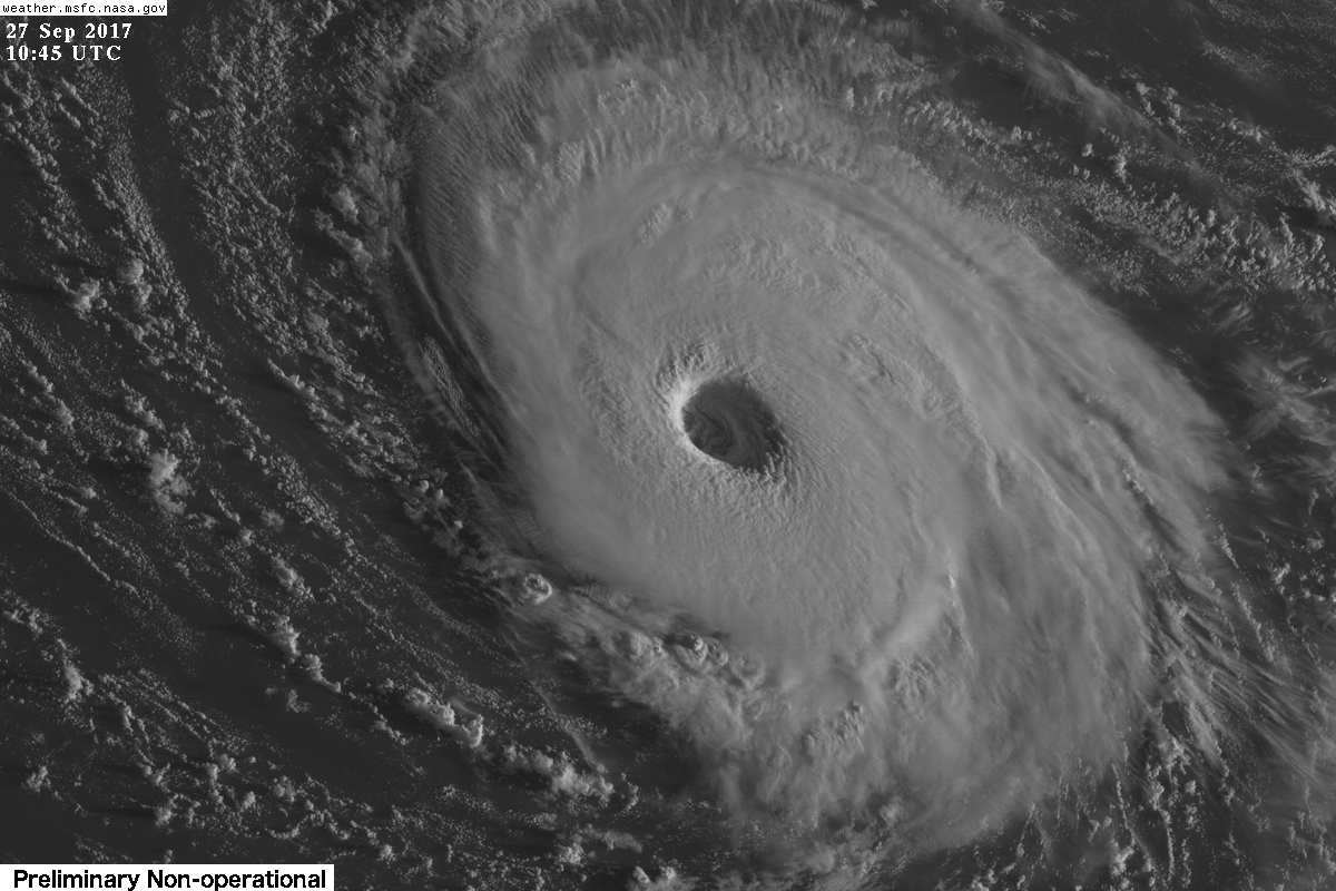
Lee est un cat. 3 maintenant - à cette latitude mmm...
-
Lee est un cat. 3 maintenant - à cette latitude mmm...

-
Observations du 25 sep au 1 oct 2017
Pooram a répondu à un(e) topic de beachcp31 dans Discussions générales
Pas beaucoup d'humidité quand même en ce moment ici... 55% Mise à jour 43% -