YCL BOY
-
Compteur de contenus
96 -
Inscription
-
Dernière visite
-
Jours gagnés
4
Type de contenu
Profils
Forums
Events
Gallery
Tout ce qui a été posté par YCL BOY
-
Éclipse Solaire Total du 3-Nov-2013
YCL BOY a posté a topic dans Observations de phénomènes astronomiques
Intéressant comme aventure, une chasse au éclipse. http://www.launchphotography.com/Total_Solar_Eclipse_2013.html http://www.launchphotography.com/Total_Solar_Eclipse_2013.jpg Total Solar Eclipse 2013 ... zero seconds? November 3, from a plane at 44,000 feet & 600 miles southeast of Bermuda Homepage Astrophotos Purchase Photos! Total Solar Eclipse of November 3, 2013, as seen from 44,000 feet over the Atlantic aboard a 12-person Dassault Falcon 900B jet chartered from Bermuda. For the first time ever, an aircraft was used to intercept an extremely short eclipse with a perpendicular crossing of the eclipse path. There was zero margin for error, with the plane, traveling near 500mph and hitting the eclipse shadow where it touched down on earth at some 8,000 mph, required to hit a geographic point over the ocean at a precise instant (read on). It is also just the second time a flight to intercept any such super-short eclipse was accomplished successfully! (It was calculated to be seven seconds in our case had we hit dead center, but it appears, being about one second off, we got an instantaneous totality of zero seconds.) The shorter-than-normal 2013 total solar eclipse was classified as a 'hybrid', which meant that for a portion of its narrow track across Earth (in this case, only a very short section at the western end of the track south of Bermuda), it was annular. The path of this total eclipse, which began there, then took it across the Atlantic and into equatorial Africa, ending in Kenya/Ethiopia/Somalia at local sunset. At that end of the path, as from here, the duration was some 15-to-ten seconds or less. At its maximum, in the ocean west of Gabon, totality lasted as much as 99 seconds, still much shorter than the majority of total eclipses. Only a few die-hard eclipse chasers made the trek or voyage to this area. While chartered flights to intercept total solar eclipses have become almost a regular event each time, a plane would normally fly with the eclipse path and wait for the shadow to catch up with the plane, making it easier. (Stay tuned for this at the next total eclipse, March 20, 2015.) Prior to this flight, in 1986, eclipse veteran Glenn Schneider was able to intercept a 'perfect' (sun and moon exactly the same size) zero-second eclipse over the north Atlantic (a similar intercept for a 1.4 second eclipse was attempted in 1930 without success). But for our flight, where the sun would have been in front of the plane and not to the side had we followed the path, we had to cross the path at close to a 90-degree angle at the moment the shadow passed by. There was high risk for our flight in being a hair off in timing and missing totality, but we did it anyway! (Debate is ongoing about whether we achieved an instant of totality or were right at the edge, but we were within about one second of it). Special thanks to veteran eclipse chaser and friends Don Hladiuk and Robert Minor for help taking the photos out our narrow windows, both literally and figuratively, of timing and space aboard the small aircraft. Special thanks to organizers Stephan Heinsius, Dirk Ewers and expert eclipse mapper & navigator Xavier Jubier, and of course the pilots! Our other group members (12 + crew) included eclipse veterans Liz O'Mara, Tony Crocker, Daniel Lynch, Leo Metcalfe, Hildegard Werth (ZDF German TV), Martin Amick (Pilot, Longtail Aviation), Hans-Williams Randriamanatena (Copilot), Arturo Garcia (Longtail tech), and also Ludger Nüschen (ZDF). (NOTE: Telephoto images suffered some from a combination of focus & the windows or the turbulence encountered during our intercept). Astronomy Picture of the Day! From our group: Telephoto video (Stephan) Wide angle video (Leo) In-cabin video (Stephan) German TV report from onboard Total Solar Eclipse 2012 - Australia Total Solar Eclipse 2008 - Siberia Sequence below is available as straight-across, vertical, square or other layouts as well: http://www.launchphotography.com/Total_Solar_Eclipse_2013_7.jpg -
Observations du 29 juillet au 4 août 2013
YCL BOY a répondu à un(e) topic de Regg001 dans Discussions générales
14:50 Orage faible à Prévost, 2 min de petites grêle d'environ 1cm. -
Observations du 1 au 7 juillet 2013
YCL BOY a répondu à un(e) topic de Trapper dans Discussions générales
Sur le site MODIS de la NASA: http://modis.gsfc.nasa.gov/index.php La fumée au dessus de L'Atlantique. http://visibleearth.nasa.gov/view.php?id=81526 http://eoimages.gsfc.nasa.gov/images/imagerecords/81000/81526/newfoundland_tmo_2013174_tn_grid.jpg Et puis la fumée rendue en Europe ! http://modis.gsfc.nasa.gov/gallery/individual.php?db_date=2013-07-07 http://eoimages.gsfc.nasa.gov/images/imagerecords/81000/81523/spain_tmo_2013178_tn_grid.jpg Sediment, Smoke, and Stained Ice in Quebechttp://visibleearth.nasa.gov/view.php?id=81556 http://eoimages.gsfc.nasa.gov/images/imagerecords/81000/81556/Canada_amo_2013179.1810_tn_grid.jpg Cheers, -
Observations du 1 au 7 juillet 2013
YCL BOY a répondu à un(e) topic de Trapper dans Discussions générales
Wow! très belle photos, ça me semble être un Pyrocumuloninbus, (PyroCB). J'en ait déjà vue plusieurs dans le Nord-ouest Ontarien mais ça reste toujours impresionant... http://fr.wikipedia.org/wiki/Pyrocumulus Un pyrocumulonimbus (pyroCb) est un cumulonimbus qui se forme au-dessus d'une source intense de chaleur. Ils ont été découverts lors de feux de forêt14,15. Ceux-ci créent des conditions d'instabilité similaires au réchauffement diurne, en plus d’ajouter des particules fines qui peuvent servir à la condensation de la vapeur d’eau en gouttelettes16. La source de chaleur est généralement un feu intense ou une éruption volcanique, mais il peut être simplement déclenché par la chaleur des rejets d’une cheminée industrielle si l'air est déjà très instable. -
Observations du 17 au 23 déc 2012
YCL BOY a répondu à un(e) topic de Trapper dans Discussions générales
À Prévost. 2iéme épisode de bruine verglaçante qui tombe toujours, depuis 18:00 ce soir. Ce matin bruine verglaçante vers les 11:00 durée de 1.5 hrs. -
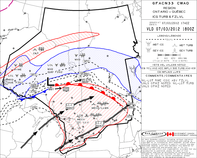
Bonjour à tous, Voici une nouvelle carte à court terme de 8 hrs de la NCAR. Pour utilisation un peut spécifique mais quand même intéressante pour certain. The NCAR-based system combines satellite data and computer weather models to produce maps of storms over much of the world's oceans. Info: http://www.nasa.gov/home/hqnews/2012/dec/HQ_12-427_Transoceanic_Turbulence.html Carte: http://www.rap.ucar.edu/projects/ocn/realtime_sys/global_extrap/ Enjoy. -------------------------------------------------------------------- RELEASE : 12-427 New NASA-Funded Forecast System Helps Transoceanic Flights Avoid Storms WASHINGTON -- A new NASA-funded prototype system developed by the National Center for Atmospheric Research (NCAR) of Boulder, Colo., now is providing weather forecasts that can help flights avoid major storms as they travel over remote ocean regions. The eight-hour forecasts of potentially dangerous atmospheric conditions are designed for pilots, air traffic controllers and others involved in transoceanic flights. The NCAR-based system combines satellite data and computer weather models to produce maps of storms over much of the world's oceans. The system is based on products that NCAR has developed to alert pilots and air traffic controllers about storms and related hazards, such as turbulence and lightning, over the continental United States. Development of the forecasts was spurred in part by the 2009 crash of Air France Flight 447, which encountered a complex of thunderstorms over the Atlantic Ocean. The system was funded by NASA's Applied Sciences Program, which supports efforts to discover and demonstrate innovative and practical uses of NASA Earth science and satellite observations. NCAR worked with the Massachusetts Institute of Technology's Lincoln Laboratory, the Naval Research Laboratory, and the University of Wisconsin-Madison to create the system. "These new forecasts can help fill an important gap in our aviation system," said NCAR's Cathy Kessinger, lead researcher on the project. "Pilots have had limited information about atmospheric conditions as they fly over the ocean, where conditions can be severe. By providing them with a picture of where significant storms will be during an eight-hour period, the system can contribute to both the safety and comfort of passengers on flights." The forecasts, which continue to be tested and modified, cover most of the Atlantic and Pacific oceans, where NCAR has real-time access to geostationary satellite data. The forecasts are updated every three hours. Pilots of transoceanic flights currently get preflight briefings and, in certain cases involving especially intense storms, in-flight weather updates every four hours. They also have onboard radar, but that information is of limited value for strategic flight planning while en route. "Turbulence is the leading cause of injuries in commercial aviation," said John Haynes, Applied Sciences Program manager at NASA Headquarters in Washington. "This prototype system is of crucial importance to pilots and is another demonstration of the practical benefit of NASA's Earth observations." Pinpointing turbulence associated with storms over the oceans is far more challenging than it is over land because geostationary satellites, unlike ground-based radar, cannot see within the clouds. Thunderstorms may develop quickly and move rapidly, rendering the briefings and weather updates obsolete. Onboard radars lack the power to see long distances or through dense clouds. As a result, pilots often must choose between detouring hundreds of miles around potentially stormy areas or flying directly through a region that may or may not contain intense weather. Storms may be associated with hazardous windshear and icing conditions in addition to lightning, hail and potentially severe turbulence. To create the forecasts, Kessinger and her colleagues first turned to geostationary satellite measurements to identify regions of the atmosphere that met two conditions: particularly high cloud tops and water vapor at high altitudes. These two conditions are a sign of powerful storms and strong updrafts that can buffet an aircraft. The scientists next used fuzzy logic and data fusion techniques to home in on storms of particular concern, and applied object tracking techniques and simulations of wind fields to predict storm locations at hourly intervals out to eight hours. Researchers verified the forecasts using a variety of data from NASA Earth observations, including the Tropical Rainfall Measuring Mission (TRMM) satellite. "These advanced techniques enable us to inform pilots about the potential for violent downdrafts and turbulence, even over the middle of the ocean where we don't have land-based radar or other tools to observe storms in detail," Kessinger said. The forecasts can be viewed at: http://go.nasa.gov/W0doRu For more information about NASA and agency programs, visit: http://www.nasa.gov - end -
-
Observations du 16 au 22 avril 2012
YCL BOY a répondu à un(e) topic de Trapper dans Discussions générales
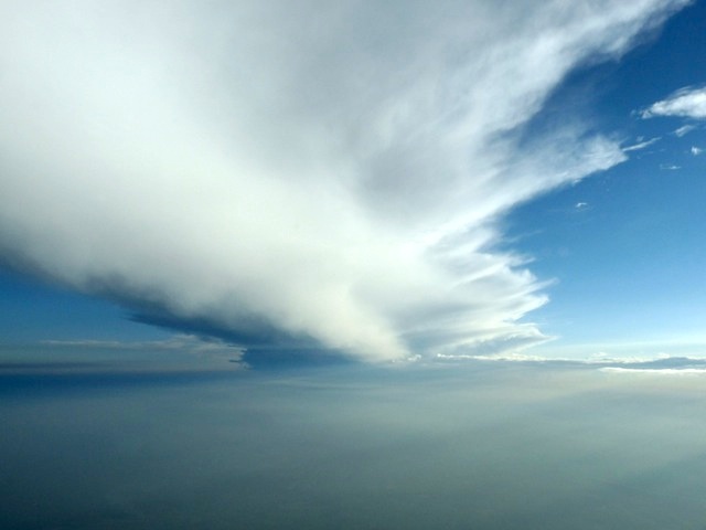
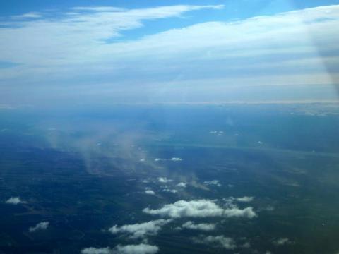
Nuage de poussières au Nord du Fleuve St-Laurent, photos prise a l'ouest du Lac St-Pierre (ce matin) mardi le 17, à 09:00.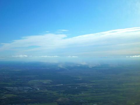
-
DISCUSSIONS PRÉVISIONS 5 au 11 mars 2012
YCL BOY a répondu à un(e) topic de Trapper dans Discussions générales
Beau Gradient de Température avec un beau Low Level Jet.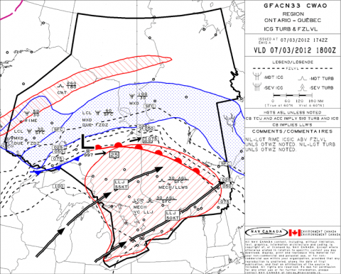
-
Observations du 20 au 26 février 12
YCL BOY a répondu à un(e) topic de Pierre dans Discussions générales
Bulletin de neige du Centre D'avalanche de la Haute Gaspesie, à bien surveiller pour les prochains jours, Soyez prudent. Enneigement ‐ Snow report Vallée (CDS) @ 230m 48 h = 75 cm 7 jours = 88 cm bulletin 120227(1).pdf -
Observations du 20 au 26 février 12
YCL BOY a répondu à un(e) topic de Pierre dans Discussions générales
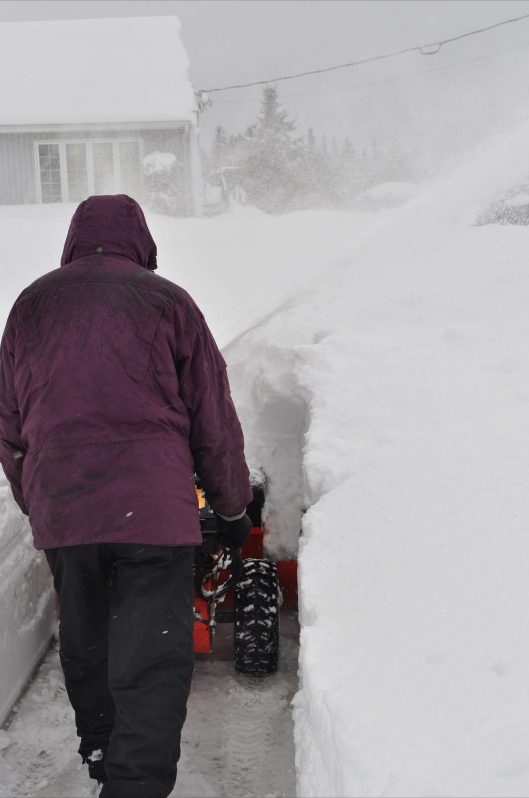
Photo chez mes parents à Dalhousie NB, le Driveway comme on le dit chez nous, à l'oeil comme ça c'est pas mal dans les record d'accumulations, à Charlo le rapport officiel et de 36 cm le vents à un jouer gros facteur. Comme référence la souffleuses à 36" de large.
-
Observations tempête de mélange des 12 et 13 janvier
YCL BOY a répondu à un(e) topic de Mistral21 dans Discussions générales
Observations de temp d'un départ de Mirabel à 09:15 Lcl ce matin le 12 janvier-2012. -Alt- / -Temp°- 3000' -5° 4000' -3° 5000' -3° 6000' -2° 7000' -4° 8000' -5° 9000' -6° 10000' -7° 11000' -7° 13000' -13° 15000' -14° -
Observations du 5 au 11 décembre 2011
YCL BOY a répondu à un(e) topic de Pierre dans Discussions générales
Chez mes parents à Dalhousie, pointe extrême Nord du NB.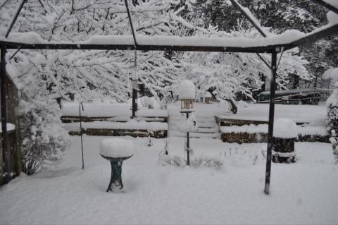
-
Pour ceux qui fréquente les Adirondack, le paysage seras différent a votre prochaine randonnées. Nouvelles Slides: http://adkbcski.com/2011/08/31/a-birds-eye-view-after-irene/ Pour ceux qui fréquente le LOJ (départ principale des randonnées high-Peaks). http://adirondackexplorer.org/out-takes/2011/08/30/1919/ Keene, NY: https://picasaweb.google.com/Deb.Kev.Adk/Ir...JayDamage82911# Keene, NY part II: http://www.townsandtrails.com/irene-update...o-keene-photos/ Petit Barage de Duck Pond qui a céder, le lac se vide: http://adirondackexplorer.org/out-takes/20...-hole-draining/ Le pont sur le Marcy Dam n'est plus en place: http://adirondackexplorer.org/out-takes/20...ge-washed-away/ http://adirondackexplorer.org/out-takes/20...h-peaks-trails/
-
Observatoire Mt-Washington. Sans surprise mais quand même impressionnant. Peak Gust: 103.6 MPH = 165 Km/h http://www.mountwashington.org/weather/conditions.php
-
Observations du 11 au 16 juil 2011
YCL BOY a répondu à un(e) topic de Trapper dans Discussions générales
Pour mes confrères du Nouveau-Brunswick. ANSE-BLEUE La petite localité dAnse-Bleue, dans la Péninsule acadienne, a été particulièrement touchée par les intempéries qui ont affecté le nord de la province, hier soir. Les forts vents ont renversé au moins deux roulottes et ont endommagé quelques propriétés. Un couple se trouvait à lintérieur de lune des roulottes, qui sest retrouvée sur le toit. La femme a subi des blessures mineures. Video de la roulotte sur le toit. http://www.capacadie.com/actualites-region...-dechaine-video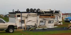
-
Observations du 18 au 24 avril 2011
YCL BOY a répondu à un(e) topic de Trapper dans Discussions générales
On peut bien voir la ligne de neige de lundi, juste au Nord du fleuve. Photo prise mardi matin vers les 09:30 sur la droite le lac Lac St-Pierre et Trois-Rivières.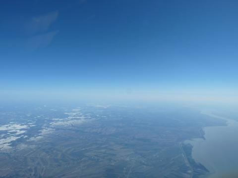
-
Observations du 29 mars au 3 avril 2011
YCL BOY a répondu à un(e) topic de Trapper dans Discussions générales
Thunder storm at Sun-N-Fun Air show. Dommage matériel $$$ Tornade en Floride jeudi le 31. http://www.eaavideo.org/video.aspx?v=873881435001 -
Model de la propagation du tsunami par la NOAA. http://www.youtube.com/user/NOAAPMEL?featu...c/3/PBZGH3yieLc
-
Pour votre plaisir. Voici quelques Température C° actuelle mesurée par un vol d'avion entre CYMX (Mirabel) et CYQB (Québec) ce matin. ----------------09:30lc 10:00lcl Altitude FT = CYMX = CYQB = Sol................+1°.........0° 2000...........................-0° 3000...............0°........+3° 4000............................... 5000.............+3°........+6° 6000.............+2°............ 7000.............+1°........+2° 8000..............-0°..........0° 9000.............................. 10000............-4°..........-3° 11000............................. 12000............-6°............. 13000............................. 14000............................. 15000...........-12°...........
-
TEMPETE MAJEURE POSSIBLE SUD DU QUÉBEC
YCL BOY a répondu à un(e) topic de Pierre dans Discussions générales
Et puis d'après le ECMWF pour Prévost. S.V.P. on ne la divise pas par 4 celle-là LOL...
-
Observations du 31 jan au 6 fév 2011
YCL BOY a répondu à un(e) topic de Pierre dans Discussions générales
METAR CYMX 021900Z 05013G25KT 1 1/2SM -SN BLSN VV010 M12/M14 A2982 RMK SN8 SLP106= D'après moi le SN8 dans la section RMK du METAR veut plus dire 8/8ième (ou 8 octas) du ciel couvert par la neige, a cause du plafond VV010 (Vertical Visibility) car c'est la visibilité verticale dans la neige qui limite le plafond et non les nuages. YCL BOY. -
Merci pour les photos Réjean, j'ai grandi à 2 min de là (Darlington-Dalhousie) donc pour moi c'est impressionnant de voir ma belle plage dans cet état, jai déjà vu des mini-banquises (genre mini-tornade LOL...) dans le milieu de cette route en hiver mais jamais tant de sable et de débris. Et puis voici un vidéo de la méme région. Part #2 .
-
DISCUSSIONS PRÉVISIONS du 22 au 28 nov 2010
YCL BOY a répondu à un(e) topic de Trapper dans Discussions générales
Voici une coupe vertical entre Sherbrooke et Québec, valid a 12Z le 26 Nov.
-
OBSERVATIONS ET PRÉVISIONS 4 ET 5 AOÛT 2010
YCL BOY a répondu à un(e) topic de Pierre dans Discussions générales
Sur le Radar, on peut bien voir les cellules que quelques-uns de vous ont intercepté près de Saint-Félix-de-Valois soit la ligne de droite sur le Radar, et puis droit devant l'écho et de la cellule des photos juste en haut, avec le centre ville de Mtl comme 2iéme écho.
-
OBSERVATIONS ET PRÉVISIONS 4 ET 5 AOÛT 2010
YCL BOY a répondu à un(e) topic de Pierre dans Discussions générales
Photo #2