Pooram
-
Compteur de contenus
6 193 -
Inscription
-
Dernière visite
-
Jours gagnés
141
Type de contenu
Profils
Forums
Events
Gallery
Tout ce qui a été posté par Pooram
-

DISCUSSIONS PRÉVISIONS du 17 au 23 juil. 2023
Pooram a répondu à un(e) topic de beachcp31 dans Discussions générales
Effectivement... -
DISCUSSIONS PRÉVISIONS du 17 au 23 juil. 2023
Pooram a répondu à un(e) topic de beachcp31 dans Discussions générales
Sans commentaire... -
Observations du 17 au 23 juil. 2023
Pooram a répondu à un(e) topic de beachcp31 dans Discussions générales
Impacte de foudre à; hmm, 200m; çà pette fort ! -
Observations du 17 au 23 juil. 2023
Pooram a répondu à un(e) topic de beachcp31 dans Discussions générales
Oui J.S. c'est au SE d'ici la cellule fait du sur-place et se renforce. Saint Mathieu et région a été touchés pendant un heure et çà bouge pas...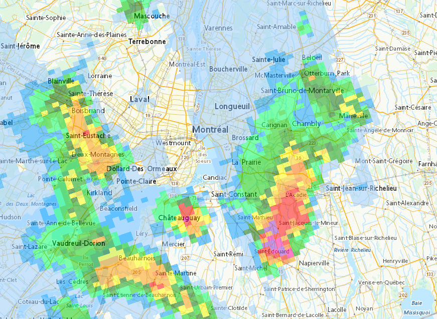
-
Observations du 10 au 16 juil. 2023
Pooram a répondu à un(e) topic de beachcp31 dans Discussions générales
Ben oui... Il tonne et pleut ici à 6h50 Et Je pense qu'il y aura des éclaircies ... -
DISCUSSIONS PRÉVISIONS du 10 au 16 juil. 2023
Pooram a répondu à un(e) topic de beachcp31 dans Discussions générales
L'Anti-biorage n'a pas d'effet avec ce genre de set-up... Lol Le phénomène est peux être même inversé ! Un bultin spécial est sortie ce matin à E C et il tonne déjà ici -
Observations du 10 au 16 juil. 2023
Pooram a répondu à un(e) topic de beachcp31 dans Discussions générales
Pour le 13; J'étais sur la route entre Beloeil et St Marc; wow Superbes belles structures nuageuses, plus impressionnant que tout ce que j'ai vue à date. Mais impossible de m'arrêter pour prendre des photos et filmer avec une petite personne à coté de moi pas très rassuré disons... -
Observations du 10 au 16 juil. 2023
Pooram a répondu à un(e) topic de beachcp31 dans Discussions générales
À Sainte Adèle comme le mentionnait Antoine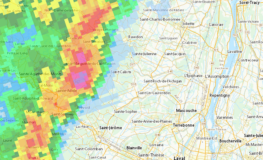
-
Observations du 3 au 9 juil. 2023
Pooram a répondu à un(e) topic de beachcp31 dans Discussions générales
On est pas dans la bonne période (3 au 9 juillet ) Ouais ! pas mal d'action et Québec est dans la mire... -
Observations du 3 au 9 juil. 2023
Pooram a répondu à un(e) topic de beachcp31 dans Discussions générales
Çà fait du bien ce petit débat, çà nous sort de la jasette de la pluie pis du beau temps... Merci ! -
DISCUSSIONS PRÉVISIONS du 10 au 16 juil. 2023
Pooram a répondu à un(e) topic de beachcp31 dans Discussions générales
Des alertes sont sorties dans le secteur de Rivière du Lièvre en autres... -
DISCUSSIONS PRÉVISIONS du 10 au 16 juil. 2023
Pooram a répondu à un(e) topic de beachcp31 dans Discussions générales
Je surveille, lol....png.aaa01f6ff504f5f2b34117160ef59753.png)
-
Observations du 3 au 9 juil. 2023
Pooram a répondu à un(e) topic de beachcp31 dans Discussions générales
Disons que c'est pas un phénomène très complexe... J'ai trouvé ça: https://en.wikipedia.org/wiki/Outflow_(meteorology) -
Observations du 3 au 9 juil. 2023
Pooram a répondu à un(e) topic de beachcp31 dans Discussions générales
Le Policier qui a fait son rapport à propos de cet égout a mentionner: ''NE COLLABORE PAS'' ... Ici hier soir : Bon gros orage ici avec une activité électrique considérable et un 10 à 15 mm de pluie, La cellule a passer entre Saint jean sur Richelieu et nous et il y avait un fort ''out-flow'' qui donnait un vent du Sud -
Observations du 3 au 9 juil. 2023
Pooram a répondu à un(e) topic de beachcp31 dans Discussions générales
Sur Sherbrooke...
-
Observations du 3 au 9 juil. 2023
Pooram a répondu à un(e) topic de beachcp31 dans Discussions générales
Bien vraie; latin de tempéremment mais pas vraiment de sang... Les petites cellules ont rafraichie un peu l'air pour une bonne heure, le soleil est revenue en force vers 17h mais une couche de nuages s'est mise en place un peu avant 19h. 30,8 C à 18h Je bois de l'aubier de tieule et de l'eucaliptus; çà ralentie le toutou Ajout 21h18: Bonnes cellules orageuses au S E -
Observations du 3 au 9 juil. 2023
Pooram a répondu à un(e) topic de beachcp31 dans Discussions générales
Deux ou trois cellules se dirigent vers la rive sud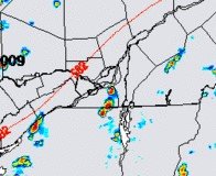
-
Observations du 3 au 9 juil. 2023
Pooram a répondu à un(e) topic de beachcp31 dans Discussions générales
En fait tout çà va se rejoindre et... crakk -
Observations du 3 au 9 juil. 2023
Pooram a répondu à un(e) topic de beachcp31 dans Discussions générales
Finalement et très rapidement çà se développe sur Montréal -
Observations du 3 au 9 juil. 2023
Pooram a répondu à un(e) topic de beachcp31 dans Discussions générales
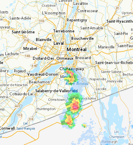
Il se développe, depuis 11h des petites cellules sur le Bassin La Prairie en particulier mais de Chateauguay à Boucherville sur toute la rive sud. Atmosphère orageuse agréable avec du tonerre en masse... 12h28: 26,1 C vent SSO calme -
Observations du 26 juin au 2 juil. 2023
Pooram a répondu à un(e) topic de beachcp31 dans Discussions générales
Attention Sorel ! Des cellules vraiments intenses dans les environs: Assomption, Rawdown ... -
Observations du 26 juin au 2 juil. 2023
Pooram a répondu à un(e) topic de beachcp31 dans Discussions générales
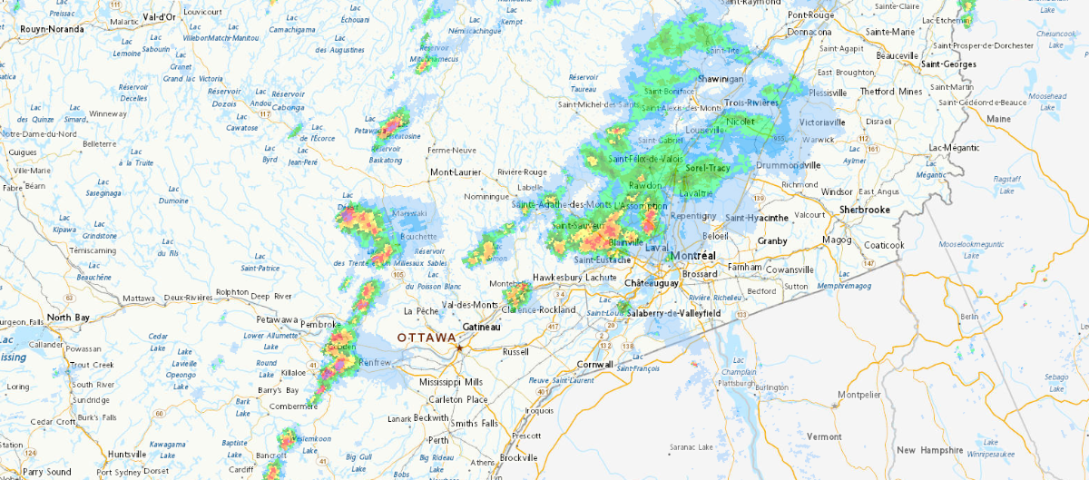
Une bonne ligne en formation à L'O d'Ottawa Je ne sais pas pour la montérégie mais au N de Montréal...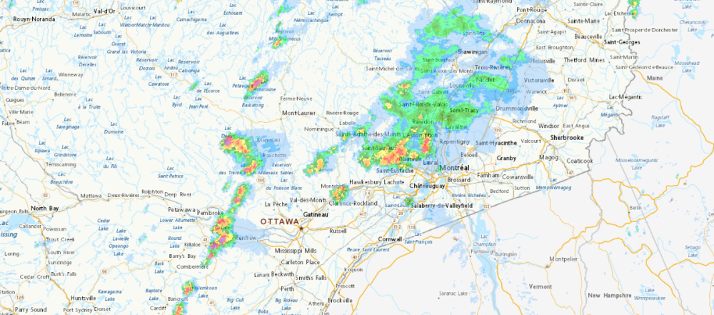
-
DISCUSSIONS PRÉVISIONS du 26 juin au 2 juil. 2023
Pooram a répondu à un(e) topic de beachcp31 dans Discussions générales
J'étais justement pour dire que se serait le NAM qui ... Mirabel a eu le gros lot jusqu'à présent semble t'il... Nous rien à date... -
Observations du 19 au 25 juin 2023
Pooram a répondu à un(e) topic de beachcp31 dans Discussions générales
Juste pour clore la période; un beau dimanche ensoleillé, hmm...
-
Oui merci: Arlene, Bret, Cindy, Don, Emily, Franklin, Gert, Harold, Idalia, Jose, Katia, Lee, Margot, Nigel, Ophelia, Philippe, Rina, Sean, Tammy, Vince, Whitney