
Pooram
-
Compteur de contenus
6 194 -
Inscription
-
Dernière visite
-
Jours gagnés
141
Type de contenu
Profils
Forums
Events
Gallery
Tout ce qui a été posté par Pooram
-

Observations du 13 au 19 juin 2016
Pooram a répondu à un(e) topic de Trapper dans Discussions générales
Un peu plus gros ici - pois chiches disons... Ça a l'air de frapper fort à St Lambert -
Observations du 6 au 12 juin 2016
Pooram a répondu à un(e) topic de Trapper dans Discussions générales
Vent agaçant à la longue ici mais très vivable ce climat - je suis aller faire un long tour de deux roues en manteau d'hivers et en sandalles (pieds nues) -
DISCUSSIONS PRÉVISIONS du 13 au 19 juin 2016
Pooram a répondu à un(e) topic de Trapper dans Discussions générales
Accollade cher Jean S. ! Mais je pense qu'il y aura anomalie(s) de toute factures jusqu'en septmbre. -
Observations du 30 mai au 5 juin 2016
Pooram a répondu à un(e) topic de Trapper dans Discussions générales
Le 20mm de EC est largement atteint ici - pluie abondante et averses du vent modéré aussi. ajout: Moins forte la pluie maintenant -
Observations du 30 mai au 5 juin 2016
Pooram a répondu à un(e) topic de Trapper dans Discussions générales
Le soleil sort... 21c - très humide. Entendez vous le tonerre ? moi non plus... calmez vous et respirez en pensant qu'il y a un orage - détendez vous... ---- fatiguant -
Observations du 23 au 29 mai 2016
Pooram a répondu à un(e) topic de Trapper dans Discussions générales
Join the club ! juste un amateur aussi Jean François ! les 3 petits points étaient la pour dire que tu le savait sans doute que c'était la force d'un ouragan. et merci Dave. Juste le son de ce type de vent c'est quelque chose. -
Observations du 23 au 29 mai 2016
Pooram a répondu à un(e) topic de Trapper dans Discussions générales
C'est le vent de base d'un ouragan de catégorie 1... -
Observations du 23 au 29 mai 2016
Pooram a répondu à un(e) topic de Trapper dans Discussions générales
Bon, il faut dire que c'est foutu pour un orage de jour - avec le soleil... Toutes les pelouses de la villes ou de l'état sont mortes, fini ! - une alumette à terre pis le feux prend partout... Très sec comme en fin de juillet. -
DISCUSSIONS PRÉVISIONS du 30 mai au 5 juin 2016
Pooram a répondu à un(e) topic de Trapper dans Discussions générales
Attention aux vents demain - surtout évidamment, s'il y a orage fort... -
Observations du 23 au 29 mai 2016
Pooram a répondu à un(e) topic de Trapper dans Discussions générales
Croik croik - oiseau de malheur ! ------------------------------ -
Observations du 23 au 29 mai 2016
Pooram a répondu à un(e) topic de Trapper dans Discussions générales
L'shauleille perche laa - mm, j'ai la ouche pl-eine... Juste un ti trou... Si il sort comme il faut les orages vont se former TGV -
Observations du 23 au 29 mai 2016
Pooram a répondu à un(e) topic de Trapper dans Discussions générales
Ouais - plutôt "mignonnes" ces tit cellules. Ajout: Veille d'orages violents - 16h04 HAE le vendredi 27 mai 2016 Veille d'orages violents en vigueur pour : secteur de Châteauguay - La Prairiesecteur de l'île de Montréalsecteur de Lavalsecteur de Longueuil - Varennes -
Le GFS toujours:
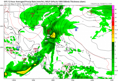
-
Donc aucun Capverdien ...
-
Les prévisions : Et une présentation/ explication à propot de l'immeuble fédéral inauguré en 2007. etc.. U.S. Meteorologists briefed reporters on the 2016 hurricane season outlook. http://www.c-span.org/video/?410239-1/noaa-officials-brief-reporters-2016-hurricane-season
-
Il est claire que les conditions sont favorables - Area Forecast Discussion National Weather Service San Juan PR 150 PM AST THU MAY 26 2016 Over the weekend and into early next week...the deep layered trough is forecast to become amplified over the Bahamas and Cuba through the weekend. This will support better moisture transport across the east and northeastern Caribbean. By Sunday and into early next...week upper ridge aloft is forecast to erode as the deepening trough will sink southwards across Hispaniola and the Mona Passage. Recent model guidance continued to suggest a wetter pattern during the latter portion of the weekend as the upper trough amplifies over the Greater Antilles. This scenario will lead to deep tropical moisture transport across the local area. The expected high moisture pooling combined with favorable upper level conditions will increase the potential for enhanced and organized convection across the forecast area... especially Sunday and into early next week. This expected moist weather pattern is all dependent on how the expected weather pattern unfolds over the western Atlantic during the next few days. Regardless... all models suggest a much wetter pattern during the latter part of the Memorial day weekend.
-
Observations du 23 au 29 mai 2016
Pooram a répondu à un(e) topic de Trapper dans Discussions générales
La pluie mortel: ***Dangerous flash flood event ongoing over SE TX*** 10-14 inches of rain has fallen this afternoon over Washington County with 6-8 inches over N Waller and southern Montgomery Counties. Damaging flash flooding is in progress over the area with numerous roadways impacted and some homes flooding in N Waller and S Montgomery Counties. Large MCS responsible for this is slowly sagging S while training W to E along and N of I-10. Line has become increasing fragmented in the last few hours, but cells along this line remain strong and capable of intense hourly rainfall rates of 2-4 inches. 1-hr rainfall rate of 4.6 inches was recorded in Conroe earlier this evening. Significant flash flooding is in progress in many locations and travel should be avoided. Do NOT drive into high water. Hydro: Working several developing situations…especially the Brazos where rain “bomb” near Brenham will send a major flood wave down this system. Early forecast looks like Memorial Day 15 levels for Waller, Fort Bend, and Brazoria Counties, but we are not done and may need to push more water into the system. Worried about the West Fork at Humble also with 6-8 inches over the headwaters of this basin. Tremendous flow is going into Spring Creek and rises to overbanks is likely upstream of SH 249. -
Observations du 23 au 29 mai 2016
Pooram a répondu à un(e) topic de Trapper dans Discussions générales
Une caméra est solidement fixée au sol en espérant que la tornade du 25 mai Ks 10km de Abilene passe dessus ... le résultat: La cam est délogé à la fin par côté opposé de la tornade. -
Observations du 23 au 29 mai 2016
Pooram a répondu à un(e) topic de Trapper dans Discussions générales
Y a un petit quelque chose en développement pour Laval - Montréal pas gros gros mais ça peut être fort... Ajout: NON -
Observations du 23 au 29 mai 2016
Pooram a répondu à un(e) topic de Trapper dans Discussions générales
Ou se trouve cet endroit ? est ce dans chaudière A ? -
Observations du 16 au 22 mai 2016
Pooram a répondu à un(e) topic de Trapper dans Discussions générales
Le risque d'orage pour demain est disparue du site meteomedia... Ils devraient attendre à ce soir tard avant de faire ce changement... -
Observations du 16 au 22 mai 2016
Pooram a répondu à un(e) topic de Trapper dans Discussions générales
Belle soirées sans moustiques et sans vent - La pleine lune des fleurs. -
Observations du 16 au 22 mai 2016
Pooram a répondu à un(e) topic de Trapper dans Discussions générales
Oui et aussi dans la région Panhadle dans l'ouest du Tx - du gros aussi... -
Observations du 16 au 22 mai 2016
Pooram a répondu à un(e) topic de Trapper dans Discussions générales
Si ça pouvait juste être un peu plus poivré, je serai ravi... -
Observations du 16 au 22 mai 2016
Pooram a répondu à un(e) topic de Trapper dans Discussions générales
E x a c t e m e n t ! j'avais remarquer ça autour de 13h. Ça commencait avec le bourgeonnement très parsemé et général. Erick en avait poster un échantillon mon adjudent.