Pooram
-
Compteur de contenus
6 196 -
Inscription
-
Dernière visite
-
Jours gagnés
141
Type de contenu
Profils
Forums
Events
Gallery
Tout ce qui a été posté par Pooram
-

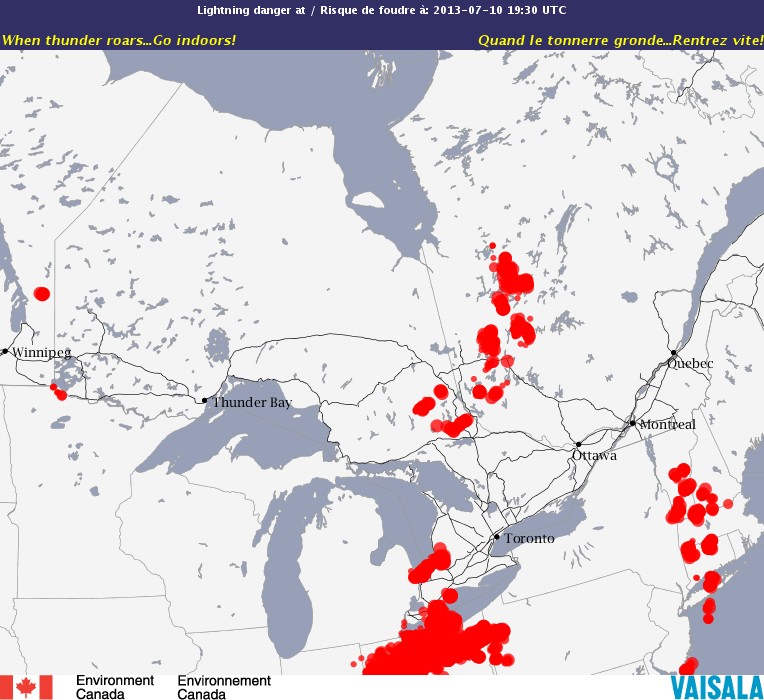
Observations du 15 au 21 juillet 2013
Pooram a répondu à un(e) topic de Trapper dans Discussions générales
Assé costode la seconde ligne à l'O de Montréal - va t'elle s'assoire ? -
Observations du 15 au 21 juillet 2013
Pooram a répondu à un(e) topic de Trapper dans Discussions générales
Nuages et vents un petit peu plus forts ... -
Observations du 15 au 21 juillet 2013
Pooram a répondu à un(e) topic de Trapper dans Discussions générales
Ici le vent a été de fort à très fort - 10k/h de plus et s'aurait été violent La ligne qui vient me semble plutôt freluquette et désorganisés... bien que très rapide et sans doute avec éléments dangereux... oui bow echoe mais "ventilée..." -
DISCUSSIONS PRÉVISIONS 15 au 21 juillet 2013
Pooram a répondu à un(e) topic de Trapper dans Discussions générales
Zeus - ...mmm, une deuxième ligne... plus faible oui, enfin on va voir mais j'ai rarement vue deux lignes toutes deux de fortes intensitées se suivre avec ce timing la. -
Observations du 15 au 21 juillet 2013
Pooram a répondu à un(e) topic de Trapper dans Discussions générales
..."moins qui était sur le point de revenir vers l'est" - Su questo punto io non vi capisco ? -
Observations du 15 au 21 juillet 2013
Pooram a répondu à un(e) topic de Trapper dans Discussions générales
Hier quand j'ai écrit "visibilité NUL", les vents ont pris solide et pouf le courant a lâché - panne complête, téléphonne compris et jusqu'à 22h45. Orage solide à tout les niveaux. Je pense qu'à l'ouest de ma région aussi. -
Observations du 15 au 21 juillet 2013
Pooram a répondu à un(e) topic de Trapper dans Discussions générales
Visibilitée NUL - !!!!!!!!!!!!!!!!!!!!!!!!!!!!!!!!!!!! -
Observations du 15 au 21 juillet 2013
Pooram a répondu à un(e) topic de Trapper dans Discussions générales
Rive sud O - orage pour l'instant modéré - le sauna - foudre intéressant, beaucoup de jus... vents modérés. En fait tout ce complexe de cellules s'écrase au dessus de MTL. Ajout - ça prend de la force -
DISCUSSIONS PRÉVISIONS 15 au 21 juillet 2013
Pooram a répondu à un(e) topic de Trapper dans Discussions générales
Voila ! -
DISCUSSIONS PRÉVISIONS 15 au 21 juillet 2013
Pooram a répondu à un(e) topic de Trapper dans Discussions générales
Vous voulez dire bon timing pour: le setup atmosphérique ou la disponibilité des chasseurs ? Mais pour Montréal, cc'est très difficile à définir "un bon timing" à cause de l'orographie nottament - mais je parle seulement en tant qu'observateur pas de spécialiste. Les cellules orageuses venant sur cette zone par: O - SO - ou NO, ont "souvent" des tendances prévisibles et déceventes ... -
Observations du 8 au 14 juillet 2013
Pooram a répondu à un(e) topic de Trapper dans Discussions générales
Merci Jean-François pour le foudre machin, je me rend compte que je n'étais pas enregistré. Mais ceci: qui est permis de publier pour le moment: Effectivement à "l'heure du souper" ...
-
Observations du 1 au 7 juillet 2013
Pooram a répondu à un(e) topic de Trapper dans Discussions générales
mmm... petit quelque chose en approche sur Montréal et rive sud - pas de foudre pour l'instant mais... Ajout: Non, il n'y a pas chose qui... enfin s'il n'y a pas de front j'aimerais autant qu'il ne pleuve pas, si vous voyez ce que je veux dire... -
Observations du 24 au 30 juin 2013
Pooram a répondu à un(e) topic de Trapper dans Discussions générales
Non - Une coupe de grandes toures très hautes avec plein d'intranuageux jusqu'à minuit au moins -
Observations du 24 au 30 juin 2013
Pooram a répondu à un(e) topic de Trapper dans Discussions générales
Pfff... -
Observations du 24 au 30 juin 2013
Pooram a répondu à un(e) topic de Trapper dans Discussions générales
Oui mais ça m'a l'air de s'écraser aussi pour vous autres... -
Observations du 24 au 30 juin 2013
Pooram a répondu à un(e) topic de Trapper dans Discussions générales
Écrasement mageur des cellules ici - vent en rafales 60 kh - 70 kh pluie courte et quelque éclaires dans lontain voisinage... Je soupsonne Montréal -
Observations du 24 au 30 juin 2013
Pooram a répondu à un(e) topic de Trapper dans Discussions générales
meteomedia propose que l'on soit atteint vers 18h - 18h30 par ce qui se développe au NO - pas grand chose à dire la dessus.... -
Observations du 24 au 30 juin 2013
Pooram a répondu à un(e) topic de Trapper dans Discussions générales
Je pense que je vois ça - malgré le voile d'humidité, Mt tremblant ??? -
Observations du 24 au 30 juin 2013
Pooram a répondu à un(e) topic de Trapper dans Discussions générales
Je voyais cette cellule il y a 25 mi, mais ma blonde m'a téléphonner... donc entre Maniwaki et Pembroke. Pour nous Montréal - cette cellule (zone) d'Ottawa-Gatineau ? -
Observations du 24 au 30 juin 2013
Pooram a répondu à un(e) topic de Trapper dans Discussions générales
Enbêtant cette panne... J'espère que ça va se régler dans les heures qui viennent Au US l'Iowa est dans la grosse flotte - orages dangeureux. - Des amis à Fairfield et Cedar Rapids parlent de 8 à 10 pouces de pluies... -
DISCUSSIONS PRÉVISIONS 17 au 23 juin 2013
Pooram a répondu à un(e) topic de Trapper dans Discussions générales
Muite bom ! Façon de parler... Ici le soleil s'est voilé depuis maintenant 90mi - ça c'est moins bom Il fait quand même 23, comme Montréal qui est dégagé Ajout - j'ai décidé de supprimer la carte des USA... -
DISCUSSIONS PRÉVISIONS 24 au 30 juin 2013
Pooram a répondu à un(e) topic de Trapper dans Discussions générales
Donc pour le 27 - 28, on pourrait parler de risque de setup vigoureux ? -
Observations du 17 au 23 juin 2013
Pooram a répondu à un(e) topic de Trapper dans Discussions générales
Curieux, St Hubert donne vent à 11kh... il n'y a rien ici 19c - la pluie a cesser et j'espérais une sortie de galarneau (soleil) avant son coucher Quel journée désolente et ça sent mauvais en plus dehors - usines... les sols sont bien humides Pas beaucoup de moustiques - yé ! une bonne chose -
Observations du 10 au 16 juin 2013
Pooram a répondu à un(e) topic de Trapper dans Discussions générales
Le sud de Montréal et la rive sud pourrait voir quelques flash et même... un orage ----------- -
Observations du 10 au 16 juin 2013
Pooram a répondu à un(e) topic de Trapper dans Discussions générales
Ahhh mon Erol... le pti remontant qui me manquais ! Budds en a sortie une nouvelle - "budds cyanure" - awoy don, une tite mousse