
Pooram
-
Compteur de contenus
6 196 -
Inscription
-
Dernière visite
-
Jours gagnés
141
Type de contenu
Profils
Forums
Events
Gallery
Tout ce qui a été posté par Pooram
-

Observations du 10 au 16 juin 2013
Pooram a répondu à un(e) topic de Trapper dans Discussions générales
Puisqu'il n'y a pas grand chose ici - pour l'Iowa ça risque d'être une soiré/nuit active. -
DISCUSSIONS PRÉVISIONS 10 au 16 juin 2013
Pooram a répondu à un(e) topic de Trapper dans Discussions générales
Beaucoup de domage et Il y a destruction de bâtiments...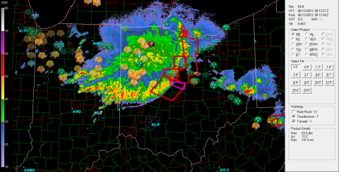
-
DISCUSSIONS PRÉVISIONS 10 au 16 juin 2013
Pooram a répondu à un(e) topic de Trapper dans Discussions générales
Je pense qu'on se paye un orage cette nuit Motréal et rive sud ! oui ? -
Observations du 10 au 16 juin 2013
Pooram a répondu à un(e) topic de Trapper dans Discussions générales
C'est un métissage ! une carte métissé - du F avec C - ça donne un 60 de temps en temps... -
Observations du 10 au 16 juin 2013
Pooram a répondu à un(e) topic de Trapper dans Discussions générales
J'ai du mamatus ici avec un ti out flow... -
Observations du 10 au 16 juin 2013
Pooram a répondu à un(e) topic de Trapper dans Discussions générales
Oui pour St Jérome je vois ça sur le radar - du NNE vers le SSO - trajectoire intéressante... "Et" Comme dit Réjean ça pulessatte, ça pulessatte ! -
DISCUSSIONS PRÉVISIONS 10 au 16 juin 2013
Pooram a répondu à un(e) topic de Trapper dans Discussions générales
Bulletin météorologique spécial terminé... ...ça va loin avant qu'on ait des flamèches avec le climat qu'on a ici ... -_-Zzzz... -
DISCUSSIONS PRÉVISIONS 27 mai au 2 juin 2013
Pooram a répondu à un(e) topic de Trapper dans Discussions générales
EC augmente les chances d'averses à 60% pour demain samedi. Les veilles sont des alertes maintenant pour le sud du lac st Jean -
DISCUSSIONS PRÉVISIONS du 13 au 19 mai 2013
Pooram a répondu à un(e) topic de Trapper dans Discussions générales
Alors, pour mercredi soir et jeudi le 16 ? - gland chose paaas ! meci ! -
Observations du 6 au 12 mai 2013
Pooram a répondu à un(e) topic de Trapper dans Discussions générales
Beau ! c'est une éclaire je crois... -------------- ------------ je suis jalous... Ici l'air est vraiment saturé d'humiditée - j'ai vue une petite cellule se développer sur Montréal (centre N.) je crois, enfin de vizoux Aussi sur l'Ile d'Orléan et Berthier sur mer, La Pocatière etc. - des cellules que je vois sur les radars -
DISCUSSIONS PRÉVISIONS du 29 avril au 5 mai 2013
Pooram a répondu à un(e) topic de Trapper dans Discussions générales
Phyllophaga Rugosa... Erick, y faut faire comme Ulys et ne pas écouter ce qu'elles te racontent...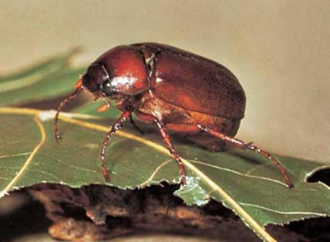
-
Observations du 22 au 28 avril 2013
Pooram a répondu à un(e) topic de Trapper dans Discussions générales
plusieurs grands flashs au dessus de Montréal encore une fois très fortes les rafales 100 et plus ici Ajout: je crois qu'il y a des dommamges au toit ... -
Observations du 22 au 28 avril 2013
Pooram a répondu à un(e) topic de Trapper dans Discussions générales
Vraiment ça soufflait fort tout à l'heure - rafale à 90 je ne sais pas trop parce que ça n'a duré que 5 minutes... On voit bien sur l'animation satellite qu'il s'est former une ligne rapidement... bon... -
Observations du 15 au 21 avril 2013
Pooram a répondu à un(e) topic de Trapper dans Discussions générales
Ahh ! quel bel après midi de printemps, quel beau samedi ! ! V'nez me rejoidre sur la piste cyclabe ! ! -----------------------------------------YYÉ ! ! ---------------------- -
Observations du 15 au 21 avril 2013
Pooram a répondu à un(e) topic de Trapper dans Discussions générales
Ici les rafales sont à plus de 90 - 100 -
Observations du 15 au 21 avril 2013
Pooram a répondu à un(e) topic de Trapper dans Discussions générales
Donc pas ici avant 19h - 20h30... -
Observations du 15 au 21 avril 2013
Pooram a répondu à un(e) topic de Trapper dans Discussions générales
Yak ! -
Observations du 15 au 21 avril 2013
Pooram a répondu à un(e) topic de Trapper dans Discussions générales
Le ciel se couvre de mamatus... Ajout: ...et pfff disparu avant Cornwall -
Observations du 15 au 21 avril 2013
Pooram a répondu à un(e) topic de Trapper dans Discussions générales
Ça se déplace à grande vitesse sur le cheddar... -
Observations du 15 au 21 avril 2013
Pooram a répondu à un(e) topic de Trapper dans Discussions générales
Oui pour les vents rive sud - rafales 80-90kh -
Observations du 15 au 21 avril 2013
Pooram a répondu à un(e) topic de Trapper dans Discussions générales
Moi de mon côté j'ai entendue/ressenti un sourde détonation vraiment pas ordinaire vers 15hrs - c'était dans sol pourrait t'on dire... pas très forte cependant. -
Observations du 8 au 14 avril 2013
Pooram a répondu à un(e) topic de Trapper dans Discussions générales
Pour les US, ça ne se passe pas comme prévue - c'est plus des avertissements de tempête hivernal que de tornades qu'ils ont besoin... le front traine... On verra demain pour le Tennessee, Ms, Al etc. Ajout: Vous reste t'il de la neige au sol dans votre région ? -
DISCUSSIONS PRÉVISIONS du 15 au 21 avril 2013
Pooram a répondu à un(e) topic de Trapper dans Discussions générales
Du moment qu'il y a une journée de temps doux à la fin juillet ... -------------------------------------- Pour ce qui est d'un retour de balancier, il faudrait que ça se vive aussi et préférablement en précipitation - l'été passé je courrais comme un fou avec des seaux d'eau pour sauver un bosquet de jeunes arbres... -
Voyage dans le Tornado Alley 2013
Pooram a répondu à un(e) topic de Mathieu Bordage dans Discussions générales
Y a déjà un truc sur la frontière Kansas/Missouri -
DISCUSSIONS PRÉVISIONS du 8 au 14 avril 2013
Pooram a répondu à un(e) topic de Trapper dans Discussions générales
US Hier... DAY 4-8 CONVECTIVE OUTLOOK NWS STORM PREDICTION CENTER NORMAN OK 0345 AM CDT SAT APR 06 2013 VALID 091200Z - 141200Z ...DISCUSSION... MULTI-DAY SEVERE WEATHER EPISODE IS EXPECTED ACROSS PARTS OF THE S-CNTRL AND PERHAPS EVENTUALLY THE SERN CONUS IN ASSOCIATION WITH AN UPPER-LEVEL TROUGH PROGRESSING EWD FROM THE WRN CONUS. PRECEDING DAYS OF SLY RETURN FLOW OF A MODIFIED GULF AIR MASS BENEATH A STOUT EML SHOULD YIELD AT LEAST MODERATELY UNSTABLE CONDITIONS AHEAD OF THE PLAINS DRYLINE BEING OVERTAKEN BY A COLD FRONT THAT WILL PROGRESS EWD DURING THE PERIOD. WITH STRENGTHENING OF MID-LEVEL SWLYS AS THE SPEED MAX EJECTS FROM THE BASE OF THE WRN CONUS TROUGH...SETUP SHOULD BE FAVORABLE FOR SUPERCELLS AND AN EVENTUAL SQUALL LINE WITH ALL MODES OF SEVERE /SOME SIGNIFICANT/ PROBABLE DURING D4-5. STILL...CONFIDENCE IS ONLY AVERAGE FOR HIGHLIGHTING CORRIDORS OF ENHANCED COVERAGE PROBABILITIES /AOA 30 PERCENT/ AS MODELS REMAIN MODERATELY DIVERGENT WITH TIMING OF THE KEY SYNOPTIC FEATURES DURING THIS TIME FRAME. DISCREPANCIES WITH EVOLUTION OF THE UPPER-LEVEL TROUGH AND ATTENDANT COLD FRONT BECOME EVEN GREATER BY D6-7...WHERE SEVERE WEATHER AREAS COULD EVENTUALLY BE WARRANTED IN PARTS OF THE SOUTHEAST.