colapster89
Membres-
Compteur de contenus
1 147 -
Inscription
-
Dernière visite
-
Jours gagnés
2
Type de contenu
Profils
Forums
Events
Gallery
Tout ce qui a été posté par colapster89
-
Chasse du 17 Mai 2008: Outaouais
colapster89 a répondu à un(e) topic de MeteoDucky dans Discussions générales
y'en a des chanceux -
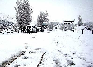
Tuesday, May 20, 2008 Direct Link: http://www.mercopress.com/vernoticia.do?id...61&formato=html Registered User Log-In E-Mail: Password: Climatic emergency in Comodoro Rivadavia hit by snow storm A climatic emergency was declared Monday in Comodoro Rivadavia following strong winds, rain and snow storms which covered most of the Argentine Patagonian province of Chubut with several feet of snow. After Chaiten volcano ashes, heavy snow under Esquel Zoom Some of the main roads remained blocked or interrupted while several towns and cities experienced partial blackouts as power lines failed. In the city of Esquel next to the Andes and which had been suffering the consequences of the volcanic blanket from the eruption in Chile of the Chaiten volcano, the snowfall was described as historic. Mayor Rafael Williams promised that in the next 24 hours the city would again be connected by land to the rest of the province and energy restored. In Comodoro Rivadavia, the most populated city of Chubut and where snow storms are rare schools were closed down and people were advised to remain indoors. At mid morning Monday temperatures remained at minus 4 Celsius according to local weather reports. Mayor Martin Buzzi declared a climatic emergency and promised that services would be fully restored in the next 48 hours. Unusual strong winds severely damaged the energy network system downing lamp posts and street lights. The main land transport system in Chubut was also reported interrupted in several places such as highway 3 which links Comodoro with Trelew; highway 26 between Comodoro and Esquel and highway 25 from Trelew to Esquel. Some small locations to the north of the province were threatened by flooding since the drainage system was clogged with volcanic ashes. Meantime further north in Mendoza at the main border pass with Chile, traffic was interrupted by 1.5 meter high snow. The international Cristo Redentor pass was closed early Sunday afternoon on both sides of the border and is expected to remain in that condition until next Friday, according to the Argentine Public Works Department. Snow tractors are working on both sides but weather forecasts anticipate more storms. The Cristo Redentor is the main Mercosur link between the Atlantic and the Pacific oceans.
-
OBSERVATION 17-20 MAI 2008
colapster89 a répondu à un(e) topic de stefano dans Discussions générales
très jolie photo chez moi il a plu 5 min c'est tout -
Éruption volcanique majeure
colapster89 a répondu à un(e) topic de stefano dans Discussions générales
j'ai lu un article cette semaine qui disait que yellowstone explose a une intensité de IEV8 chaque 625 000 et qu'il est surment le responsble majeur de beaucoup de glaciation et selon cet article la prochaine eruption est en retard de 25 000ans -
Cool Weather Slows Crop Growth in Corn Belt 5/20/2008 AgWeb Editors Unusually cool weather continues to slow emergence and growth of summer crops in the Crop Belt, USDA's Joint Weather Facility reported Tuesday. Corn and soybean planting meanwhile is advancing rapidly in the western Belt, but remains slow due to wet fields and lingering showers in the eastern Corn Belt. Elsewhere in the U.S.: In the West, much cooler air is spreading into coastal California and the Pacific Northwestaccompanied by a few showers in the latter regionbut hot weather continues elsewhere. Rapidly melting snow packs are causing local flooding, while dryness-related stress on rain-fed winter grains and emerging summer crops is becoming more apparent. On the Plains, cool weather in the Dakotas and eastern Nebraska contrasts with above-normal temperatures elsewhere. Although most crops are benefiting from the warm weather, drought in North Dakota and the High Plains remains a concern with respect to rangeland, winter wheat, and emerging summer crops. In the South, isolated but beneficial showers dot the central part of Floridas peninsula, while cool, wet weather is slowing fieldwork in the southern Mid-Atlantic region and the interior Southeast. Near-term Outlook: Some important changes in the weather pattern will occur during the next several days. First, cool weather will return to the West, accompanied by widespread precipitation. Showers will arrive today in the Northwest, but eventually overspread most of the Intermountain West. Precipitation may exceed 2 inches in the northern Rockies and adjacent High Plains of Montana. After mid-week, thunderstorms will erupt across the Plains and the Gulf Coast region. Meanwhile, only light precipitation will fall in the Corn Belt, although cool weather will linger in the Great Lakes and Northeastern States. Extended Outlook: The National Weather Service 6- to 10-day outlook for May 25-29 calls for wetter-than-normal weather in most areas from the Intermountain West to the Mississippi Valley, while mostly dry conditions will prevail in the East Coast States. Meanwhile, warmer-than-normal conditions from the western and central Gulf Coast States to the Great Lakes region will contrast with belownormal temperatures across southern Florida, the northern Atlantic region, the northern High Plains, and much of the West.
-
Éruption volcanique majeure
colapster89 a répondu à un(e) topic de stefano dans Discussions générales
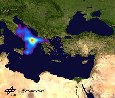
Eruption of Mt. Etna: GOME-2 sensor tracks plume from Europe to Asia 19 May 2008 SO2 plume zum Bild SO2 plume Mount Etna is a stratovolcano located on the Italian island of Sicily. Being Europes highest and most active volcano, it is one of the best monitored volcanoes worldwide and has the world's longest documented records of volcanism starting 1500 BC. Two typical eruptive styles occur at Etna, persistent explosive eruptions, sometimes with minor lava emissions and less frequently flank vents, typically with higher effusion rates. The latest eruptions of Etna started on 10 May 2008 around 16:00 CEST. The first eruption lasted for about 4 hours and was dominated by heavy activity of the south-eastern crater. High amounts of lava have been emitted, a lava fountain could be seen at the crater and several lava flows travelling down into the eastern flank of the volcano into the Valle del Bove depression were visible on one of the webcams installed to monitor the volcano. Cloudy conditions and poor visibility obstructed the monitoring of the eruption activity, but it seems that this is one of the heaviest eruptions of the south-eastern crater since 2001. A second eruption occurred on the evening of 13 May from a fissure that opened NE of the SE crater, about 800m long. Catania airport had to be closed because of ash emission from Etna. Detection of SO2 with GOME-2 Apart from the emission of lava, the eruption at Etna emitted large amounts of sulphur dioxide (SO2), a colourless and toxic trace gas, into the atmosphere. The SO2 was measured the day after the eruption, 11 May, by the atmospheric sensor GOME-2 (Global Ozone Monitoring Experiment) on the EUMETSAT satellite, MetOp-A. The SO2 plume had been transported eastwards and could be traced over Greece, with sulphur dioxide amounts of more than 20 DU (The amount of sulphur dioxide is measured in Dobson Units (DU), the number of molecules in a square centimetre of the atmosphere). Trajectory analysis revealed that the sulphur dioxide was injected into the atmosphere by Etna up to a height of 12 km.. The path of the volcanic cloud could be tracked for two more days as it moved further eastwards. On the third day after the eruption the sulphur dioxide cloud moved over Iran and the next day it could still be detected over Turkmenistan. SO2 plume on 14 May 2008 zum Bild SO2 plume on 14 May 2008 On the evening of 13 May, a second eruption occurred at Etna that continued throughout the next day, emitting again large amounts of sulphur dioxide that were detected by GOME-2 the next morning NE of the volcano, over Italy. Sulphur dioxide is emitted into the atmosphere not only by volcanic eruptions, but also by anthropogenic activity such as the combustion of fossil fuels. In some regions it contributes significantly to air quality issues. Sulphur dioxide acts as an acid. Inhalation results in laboured breathing, coughing, sore throat and may cause permanent pulmonary damage. It further plays an important role in climate change, if it finds itself in high atmospheric regions by volcanic eruptions, where it can lead to temporary cooling. Analysis of GOME-2 data at DLR The Global Ozone Monitoring Experiment-2 (GOME-2) is one of the new-generation European instruments carried on board of MetOp, which has been jointly established by ESA and EUMETSAT. GOME-2 will continue the long-term monitoring of atmospheric ozone and trace gases, such as sulphur dioxide (SO2), started in 1995 by GOME on ERS-2 and since 2002 by SCIAMACHY on Envisat. The operational processing and routine analysis of GOME-2 data are performed in DLR Oberpfaffenhofen at the Remote Sensing Technology Institute (IMF) and German Remote Sensing Data Centre (DFD). GOME-2 SO2 images are available in near-real time at the World Data Centre for Remote Sensing of the Atmosphere hosted by DLR. -
DISCUSSIONS ÉVÉNEMENTS du 19 au 25 mai 2008
colapster89 a répondu à un(e) topic de Trapper dans Discussions générales
2 geler sur 6. On a atteint le -2,2 cette nuit a sainte-agathe -
sa c'est particulier reste a voir si c'est hors de tout doute
-
(DOME A) TEMP LE PLUS FROID ?
colapster89 a répondu à un(e) topic de iceberg dans Discussions générales
sa se rapproche de jour en jour -
DISCUSSIONS ÉVÉNEMENTS du 19 au 25 mai 2008
colapster89 a répondu à un(e) topic de Trapper dans Discussions générales
tk moi je vais etre on the spot comme on dit pis jte reviens avec sa lundi. Deja 1 geler sur 6 -
DISCUSSIONS ÉVÉNEMENTS du 19 au 25 mai 2008
colapster89 a répondu à un(e) topic de Trapper dans Discussions générales
Colapster, je ne vois pas où il pourrait y avoir de la neige dans les Laurentides. Tuv voudrais bien nous montrer sur quel carte que tu as vu ça stp... regarde le gfs l'apport d'air aritc depuis le nord-ouest serra très grande et il y aura situation de blocage. Jusqu'a 532mb. BIEN SUR Montréal est exclus mnais je suis a sainte-agathe en fds et ;e risque est très élevé et ce n'est pas rare a ce temps si -
DISCUSSION ÉVENEMENTS du 12 au 18 mai 2008
colapster89 a répondu à un(e) topic de Trapper dans Discussions générales
justement et en fin de semaine il y aura un blocage froid hors de tout doute -
chose interessante ce matin il fait 0 degrer a San julian en argentine et il neige a la tierra del fuego aussi en argentine
-
DISCUSSIONS ÉVÉNEMENTS du 19 au 25 mai 2008
colapster89 a répondu à un(e) topic de Trapper dans Discussions générales
il devrait y avoir 5 gelé d'affilé a sainte-agathe-des-monts excluant celle de cette nuit, je suis de plus en plus optimiste pour voir mes derniers flocon de la saison samedi soir et dimanche soir, il y a même la possibilité d'en voir mardi soir -
Éruption volcanique majeure
colapster89 a répondu à un(e) topic de stefano dans Discussions générales
Mount Etna volcano in Sicily spouts more lava * * Email * Printer friendly version * Normal font * Large font May 15, 2008 Related coverage * Mount Etna rumbles back to life in Sicily Advertisement Mount Etna in Sicily has spouted lava for the fifth day while authorities nervously monitor cracks in the cone of Europe's biggest active volcano. An emergency services helicopter yesterday hovered over the volcano and experts saw openings on one side of the cone at between 2,700 and 2,900 metres, the regional vulcanology institute said on its website. One opening on the southeast slope is about a kilometre long, ANSA news agency said. No inhabited areas are under threat, the institute said. Etna, which erupted on Saturday, was shaken on Tuesday by "seismic events" measuring up to 3.9 on the Richter scale. The last big eruption of the 3,295 metre high Etna was in mid-2001. The nearby Stromboli volcano also rumbled into life again on Tuesday, forcing the cancellation of tourist excursions. AFP -
Observations (du 10 au 14 mai)
colapster89 a répondu à un(e) topic de dann17 dans Discussions générales
c'Est exactement sa vraiment rare -
Observations (du 10 au 14 mai)
colapster89 a répondu à un(e) topic de dann17 dans Discussions générales
D'un point de vue lagrangien (en suivant une même parcelle d'air) il doit y avoir source/puit d'humidité pour que le Td change. Mais dans le cas qui nous concerne, soit une station en surface, on peut assécher l'air simplement par advection verticale d'air sec (en plus, l'action du réchauffement diabatique augmentera la baisse d'HR). Regarde le téphi de Miniwaki ( http://meteocentre.com/upper/wmw.gif )... un Td de -5 se trouve près de 840 hPa. Tu ramène cet air au sol et hop ton Td chute à -5 Oui je suis tout à fait d'accord avec ton raisonnement Jean François. Mais dans ce cas, si on sors du cadre "théorique", comment expliques-tu une telle subsidence (faire chuter tout un volume d'air de 1500m vers le bas, c'est quand même pas banal...) ? Je ne vois sincèrement pas comment une aussi forte subsidence aurait pu se produire là et à cette heure : le vent venait du sud, et St Anicet est très loin de tout relief vers le sud et la pente est très faible... donc non vraiment je reste malgré tout encore très sceptique... J'ai peut-être tort biensûr, mais pour le moment je ne suis pas du tout convaincu... je me souviens d'une histoire qui a passer pas mal innapercus mais en 2003 je crois dans les plaines aux usa l'ozone est descendu au sol fesant chuter l'humidité a 3-4% au sol. Je ne me rappele pu du phénomène en cause faudrait chercher... l'article s'appelait quelque chose comme : le jour ou le ciel nous est tombé sur la tête... ou quelque chose qui ressemble a sa -
MOUNT St. HELENS, Wash. - On May 18, 1980, the once bucolic ice-cream cone shape that defined Mount St. Helens in Washington state disappeared in monstrous blast of ash, rock, gas, and heat. It was one of the most powerful explosions ever witnessed by humans and the force of the blast leveled hundreds of square miles of forestland, devastated wildlife and killed over 50 people. Almost three decades later, the effects of the eruption are readily apparent to the thousands of visitors to the observation points in the sprawling Mount St. Helens volcanic monument. But time has also muted the effects to some degree. Trees are growing back in some areas, plants have poked up through the ash, animals move through the devastated plains once again. And inside the volcano, which was once a soft dome of snow but is now a gaping, steaming menace with an unpredictable streak, an unexpected phenomenon is taking place: a glacier is growing . In these days of global warming concerns and scientists showing alarming then-and-now images of glaciers disappearing from mountainsides, it may be the only growing glacier in America - or maybe the world. Scientists closely monitoring the unlikely growth of the glacier say the north-south orientation of Mount St. Helens' huge crater plays an important role in growing the ice formation. The eruption 28 years ago hollowed out the center of the mountain and thrust it almost directly north, leaving a towering crater wall to shield the crater's interior from the melting effects of the sun during most months of the year, especially the winter months. Over the years since the huge eruption, the snowfall has condensed and compacted to form a horseshoe-shaped glacier inside the crater. Researcher Joseph Walder with the U.S. Geological Survey says the shade from the crater wall is allowing the glacier to grow in height by about 15 feet per year. But that's not the only thing driving the unlikely growth of the glacier, which shares the crater with a lava dome that is hot enough in most places to instantly boil water. Recent spasms of dome-building activity in the crater have forced the two arms of the glacier to move towards the mouth of the crater, where they now almost touch. Eventually, if they do connect, the frozen glacier will completely encircle the smoldering lava dome, forming a cold collar around the furnace in the middle of the mountain. But Walder cautions that a glacier inside a volcano leads a tenuous existence. A surge in volcanic activity, especially an eruption, could melt away the glacier in the space of a day, sending a torrent of water down the Toutle River in a flood that would bring widespread destruction downstream. The damage could echo the devastation wrought by the volcano 28 years ago when the rapid melting of snow and glaciers during the May 18 eruption sent muddy walls of churning water streaming from the volcano, taking out bridges, homes and trees as it rushed downhill. So far, there is no known way to accurately predict when such volcanic activity is due to take place. Mount St. Helens' volatile nature could trigger the death of the glacier at any time. Meanwhile, Walder will continue to work on making mesmerizing time-lapse movies of the ice-field's movements and studying the creeping glacier as it moves to encircle the steaming center of fire at the heart of the Mount St. Helens volcano.
-
Éruption volcanique majeure
colapster89 a répondu à un(e) topic de stefano dans Discussions générales
Separately, Chile's National Emergency Office said it was monitoring the Peteroa volcano, some 125 miles south of Santiago, after it sent up clouds of vapor. It said the vapor was normal, but specialists were being sent on Thursday to check for volcanic activity. Chile's chain of some 2,000 volcanoes -- 500 of them potentially active -- is the world's second-largest after Indonesia. (Reporting by Bianca Frigiani; Writing by Pav Jordan; Editing by Xavier Briand) © Reuters 2008 -
(DOME A) TEMP LE PLUS FROID ?
colapster89 a répondu à un(e) topic de iceberg dans Discussions générales
en effet mais ce n'est que le debut de l'hiver la-bas -
Éruption volcanique majeure
colapster89 a répondu à un(e) topic de stefano dans Discussions générales
la liste des volcans en activités a travers la planète c'est beaucoup allongée depuis le début d'avril -
Éruption volcanique majeure
colapster89 a répondu à un(e) topic de stefano dans Discussions générales
-
Éruption volcanique majeure
colapster89 a répondu à un(e) topic de stefano dans Discussions générales
-
DISCUSSION ÉVENEMENTS du 12 au 18 mai 2008
colapster89 a répondu à un(e) topic de Trapper dans Discussions générales
encore possibilité de petit flocons samedi et dimanche durant la nuit pour sainte-agathe-des-monts sa fait 3 jour que sa se maintient. Beaucoup de precipitation en fin de semaie -
Éruption volcanique majeure
colapster89 a répondu à un(e) topic de stefano dans Discussions générales
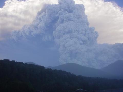
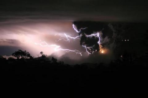
Dépêche du 14 mai 2008 : L'activité éruptive est toujours aussi intense au Chaitén. Le VAAC de Buenos Aires indique que les émissions de cendres sont toujours continues sur le volcan. Le SERNAGEOMIN et l'ONEMI ont indiqué dans leurs rapports que des coulées pyroclastiques de petite intensité ont été émises sur le flanc nord de lédifice. Ces dernières ont carbonisé la végétation qui se localise dans cette zone. L'évent éruptif principal, ouvert sur le flanc nord du dôme d'obsidienne qui occupe le fond de la caldera, atteint maintenant 1000 m de diamètre environ, et s'est ouvert jusqu'au sommet du dôme (source: VAAC de Buenos Aires; SERNAGEOMIN; ONEMI)


