DjSteph
-
Compteur de contenus
1 350 -
Inscription
-
Dernière visite
Type de contenu
Profils
Forums
Events
Gallery
Tout ce qui a été posté par DjSteph
-
Effet de lac dans l'état de New-York..
DjSteph a répondu à un(e) topic de dave20 dans Discussions générales
Question comme ca, est-ce que l'effet Lac peut être possible pour ma région (Cowansville, Duham, etc.) dû au lac Champlain à l'Ouest d'ici? Est-ce que ce sera ça qui nous aurait donner à peu près 20 cm sur 3 jours la dernière fin de semaine? -
Observation actuelle... neige forte!
DjSteph a répondu à un(e) topic de Mesorageux dans Discussions générales
Ca c'est cool! On a reçu à peu près une vingtaine de cm ici en 3 jours! 10 cm, 5 cm et 5 cm les trois derniers jours! C'est mieux que rien! -
Observation actuelle... neige forte!
DjSteph a répondu à un(e) topic de Mesorageux dans Discussions générales
On a reçu une bonne dizaine de cm ici pendant la nuit! C'est le bienvenue! -
La première semaine de février pourrais,
DjSteph a répondu à un(e) topic de Invite01 dans Discussions générales
Désolé mais je vois rien de très actif dans les 2 prochaines semaines... il faut que le "patern" actuel change... -
La première semaine de février pourrais,
DjSteph a répondu à un(e) topic de Invite01 dans Discussions générales
Il semble se dessiner un potentiel de tempête autour du 2 fév. ACW le prévoit, et le GFS aussi. Potenciel de 30 cm pour le sud du Québec. À suivre!!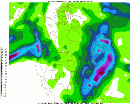
-
Neige abondante pour vendredi ?
DjSteph a répondu à un(e) topic de Mesorageux dans Discussions générales
Juste avant qu'on ajoute trop de post sur ce qui vient le 26 (y a-t-il vraiment quelque chose en vue pour le 26?), y a déjà un sujet d'ouvert pour cette date. Ca peut devenir mélangeant si on post des messages à différents endroit pour un même sujet! -
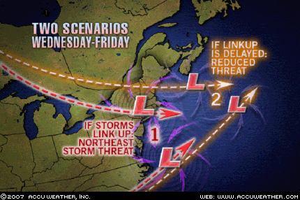
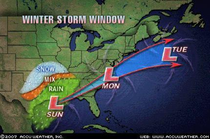
ACW en parle aussi : Another winter storm will kick out of the Southwest early next week, bringing with it the potential for some snow and ice once again in Texas, From here, this storm will hug the Gulf Coast before turning northeastwards Wednesday and Thursday. Any winter storm following such a path raises interest along the Atlantic Seaboard. So, can this storm threaten the Northeast with significant snowfall? It would seem that the key lies with another storm: a colder, northern counterpart dipping southeast from central Canada. An early mingling of forces amongst the two storms would bear with it a good potential to spin up a nor'easter along the middle and north Atlantic Seaboard. At the same time, later merging of storm energy would give rise to a storm with highest impact at sea, over eastern New England and in Atlantic Canada. It is too early to make this call, but AccuWeather.com headlines will be watching this one keenly. Story by AccuWeather.com Senior Meteorologist Jim Andrews.
-
Neige abondante pour vendredi ?
DjSteph a répondu à un(e) topic de Mesorageux dans Discussions générales
Je connais très bien cette sensation! Ca arrive très souvent ici, entre autre l'été où il a des orages partout autour sauf ici... -
Voici un lien à cette nouvelle : http://www.radio-canada.ca/nouvelles/Inter...te-europe.shtml
-
On va l'oublier celle-là... c'est rien de possitif. Ca prendrait un miracle pour qu'on soit affecté! J'ai dit quelque chose?...
-
Neige abondante pour vendredi ?
DjSteph a répondu à un(e) topic de Mesorageux dans Discussions générales
Désolé Mizar, mais ca semble débordé un peu plus chez nous que ce qui était prévu hier. C'est probablement parce qu'elle va plus vers l'Ouest, et non vers l'Est. EC a ajouté la région de Rimouski - Mont-Joli cette nuit dans les avertissements, ce qui confirme cette théorie. ACW, MM et EC s'entendent pour environ 10 cm au total pour ma région, c'est quand même apprécié! -
Neige abondante pour vendredi ?
DjSteph a répondu à un(e) topic de Mesorageux dans Discussions générales
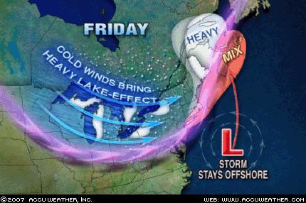
Nouvelle carte de ACW, qui confirme bien que l'Est va y gouter!! Chu jaloux!!!!!! :P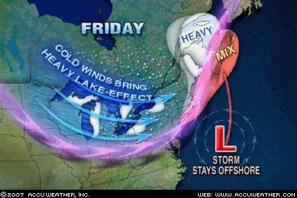
-
Neige abondante pour vendredi ?
DjSteph a répondu à un(e) topic de Mesorageux dans Discussions générales
Oakley28, il ne faut surtout par comparer MM et ACW! Bien que ACW n'a pas eu tout à fait raison pour les accumulations ici lors de notre dernière tempète, ils sont pas mal plus précis et juste que MM. -
Tempête de Neige au saguenay
DjSteph a répondu à un(e) topic de meteodave dans Discussions générales
C'est pas "Lake effect" (effet de Lac)? :P Ce même phénomène n'est produit aussi autour des grands lacs, et ACW le mentionnait plusieurs jours d'avance. Comprends pas pourquoi EC a pas pu le savoir à seulement quelques heures d'avance... -
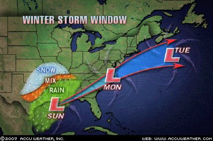
Voici ce qu'en dis John Kocet d'ACW : Without question the atmosphere is developing a much stormier look. One disturbance will give the Eastern Seaboard a close call Thursday into Friday. The next storm, which is shown here, will come on the heels of the first and could turn into quite a troublemaker. Here you see the storm's projected window of movement. This tracking format is usually reserved for hurricanes, but we thought it would be useful here to get our point across. Notice that the window expands with time, which is simply a reflection of uncertainty. If the track is farther north, it will snow all the way to New England. A track farther south would confine frozen precipitation to the Virginias, Maryland and Delaware. And here is something for all the weather lovers out there. If this storm steals the show, which it could, cold air will rush in, and that will be that. However, some evidence suggests that this storm will be moderately strong with a bigger system coming later next week. One way or the other, it's going to be an interesting period, and when the weatherman uses the word "interesting" that often means trouble. Story by AccuWeather.com Expert Senior Meteorologist John Kocet.
-
Autant partir le sujet, car les chances sont assez bonne pour une autre!! Cool!!
-
Neige abondante pour vendredi ?
DjSteph a répondu à un(e) topic de Mesorageux dans Discussions générales
WOCN70 CWUL 172045 BULLETIN METEOROLOGIQUE SPECIAL EMIS PAR ENVIRONNEMENT CANADA MONTREAL A 15H45 HNE LE MERCREDI 17 JANVIER 2007. .... TEMPETE MAJEURE DANS L'EST DU QUEBEC EN FIN DE SEMAINE .... SITUATION METEOROLOGIQUE UN SYSTEME DEPRESSIONNAIRE SE FORMERA JEUDI SUR LA COTE EST AMERICAINE ET REMONTERA VERS LE GOLFE ST-LAURENT VENDREDI TOUT EN S'INTENSIFIANT RAPIDEMENT. A L'APPROCHE DE CE SYSTEME, DES QUANTITES IMPORTANTES DE NEIGE AINSI QUE DES VENTS FORTS CAUSANT DE LA POUDRERIE SONT ATTENDUS SUR LA PENINSULE GASPESIENNE AINSI QUE LA BASSE-COTE-NORD A PARTIR DE VENDREDI EN FIN DE JOURNEE. LES PRECIPITATIONS CESSERONT GRADUELLEMENT SAMEDI MAIS LES VENTS FORTS PERSISTERONT. CE BULLETIN SE VEUT UNE SIMPLE MISE EN GARDE ET LE PUBLIC EST PRIE DE SUIVRE LES AVERTISSEMENTS ACTUELS OU SUBSEQUENTS EMIS PAR ENVIRONNEMENT CANADA. POUR TOUT COMMENTAIRE, COMMUNIQUEZ AVEC ENVIRONNEMENT CANADA AU 1-800-463-4311 -
Situation pour le 15 janvier
DjSteph a répondu à un(e) topic de meteo'rick dans Discussions générales
Ouin bin ACW s'est planté... à peine 20 cm en tout! C'est quand même mieux que rien! -
Neige abondante pour vendredi ?
DjSteph a répondu à un(e) topic de Mesorageux dans Discussions générales
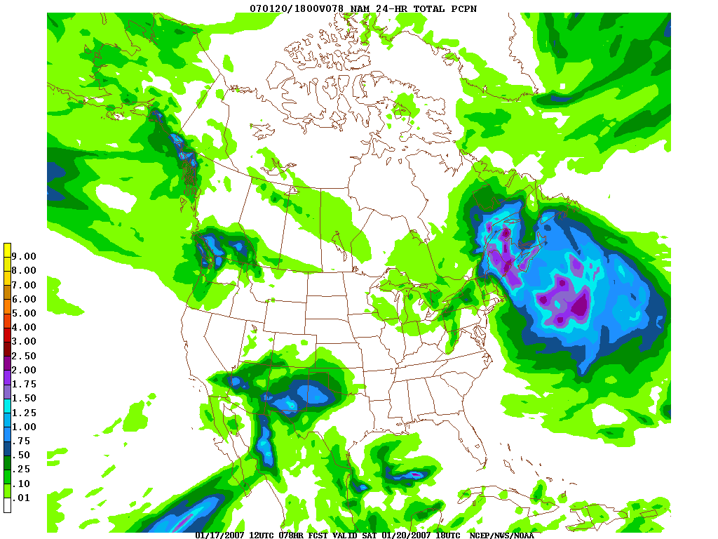
Voici le NAM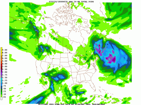
-
Neige abondante pour vendredi ?
DjSteph a répondu à un(e) topic de Mesorageux dans Discussions générales
Je vois même du potenciel pour du 50 cm et plus pour l'Est... Gagne de chanceux!!!! -
Neige abondante pour vendredi ?
DjSteph a répondu à un(e) topic de Mesorageux dans Discussions générales
Le NAM de 12 UTC donne un 15 à 20 cm possible en Estrie! Intéressant! -
C'est quoi le meilleur site pour le radar pour le sud du Québec? Dans tous ceux que je regarde, on dirait que ce n'est pas la même chose... y en a un fiable?
-
Situation pour le 15 janvier
DjSteph a répondu à un(e) topic de meteo'rick dans Discussions générales
ACW sont rendu à 40 cm comme prévision local pour ici!!!! -
Ici il neige depuis 8h00 ce matin, il fait -6 et il neige encore de modéré à fort. Difficile de dire combien il en est tombé à date, car il vente aussi. Les charrues passent en tk!
-
Situation pour le 15 janvier
DjSteph a répondu à un(e) topic de meteo'rick dans Discussions générales
Moi je vote encore pour ACW qui prévoient jusqu'à 35 cm pour ma région!!! GO GO GO ACW!!!!!!!!!