Pooram
-
Compteur de contenus
6 197 -
Inscription
-
Dernière visite
-
Jours gagnés
141
Type de contenu
Profils
Forums
Events
Gallery
Tout ce qui a été posté par Pooram
-

Observations du 16 au 22 sep 2019
Pooram a répondu à un(e) topic de beachcp31 dans Discussions générales
Ici aussi on dirait... Randonnée à vélo magique; retour avec soleil et vent calme. -
Observations du 16 au 22 sep 2019
Pooram a répondu à un(e) topic de beachcp31 dans Discussions générales
25,3 selon EC -
Observations du 16 au 22 sep 2019
Pooram a répondu à un(e) topic de beachcp31 dans Discussions générales
Bon bien, un bel été somme toute et une belle fin d'été - la seule chose c'est que çà fini 6 mois trop tôt selon certains... les danseurs de salsa et amateurs d'évènements extérieurs sont tristes; pas moi - un ti break laa laa... Observation: il y a un nouveau chant de bestiole de nuit (criquet) avez vous remarquer ? Il est vraiment puissant ?? -
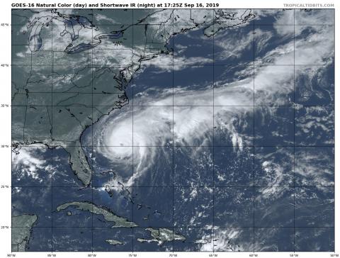
En fait c'est une possibilité à 20% disons... me vlâ rendue comme MM...
-
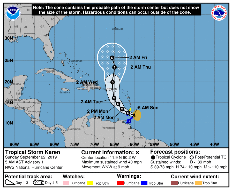
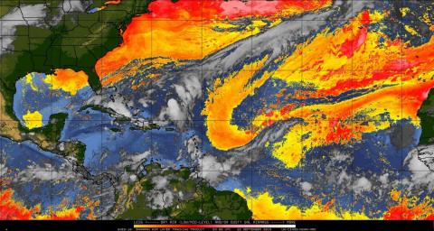
Voilà, on a Karen (99L) Remarquez la langue d'air sec et l'accumulation nuageuse des Bahamas... Karen pourrait commencer à se développer en ouragan d'ici une semaine en tournant vers l'O et même SO ...
-
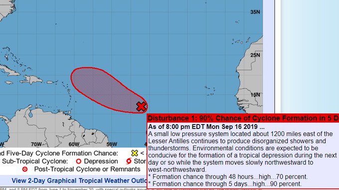
99L:

-
Allo ! qui est là ? En tous cas c'est rouge et ça va vers l'Atlantique...

-
DISCUSSIONS PRÉVISIONS du 16 au 22 sep 2019
Pooram a répondu à un(e) topic de beachcp31 dans Discussions générales
MM: El Niño : quelque chose qui semblait impossible deviendra réel ??? -
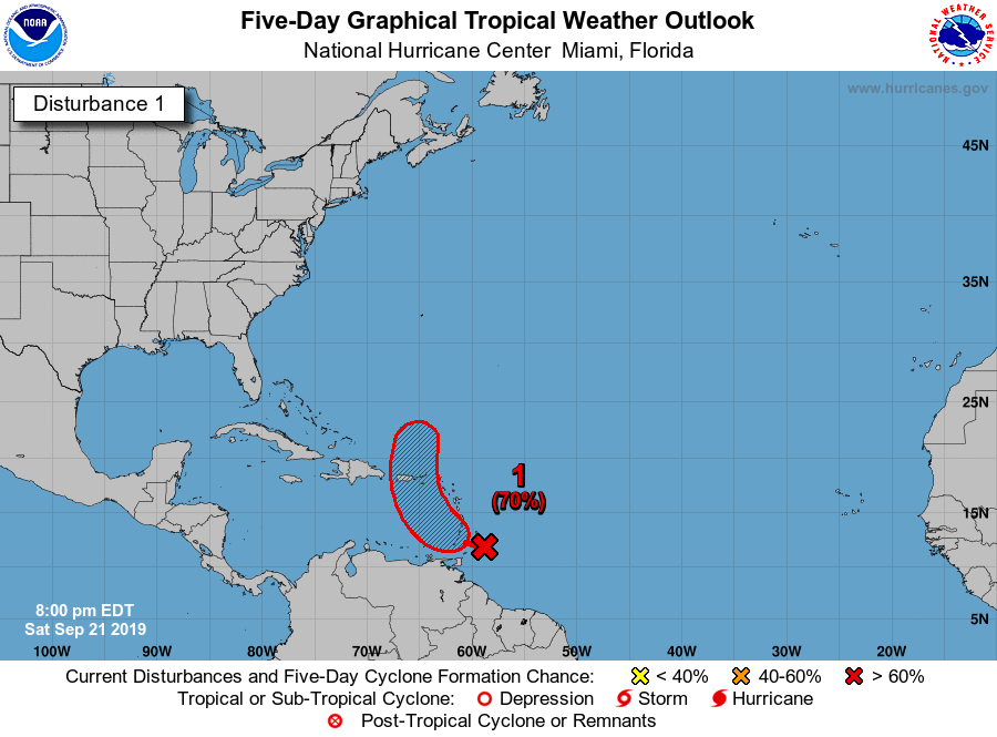
Un autre joueur dans le bassin A - 99L 30% dans 5 jours mais plus après si il survie... A tropical wave located about 700 miles east of the Windward Islands continues to produce disorganized showers and thunderstorms. The wave is expected to move quickly westward at about 20 mph during the next few days, and some development is possible while it approaches and moves across the Windward Islands this weekend. Upper-level winds are forecast to become less conducive for development once the wave moves over the eastern Caribbean Sea early next week. * Formation chance through 48 hours...low...20 percent. * Formation chance through 5 days...low...30 percent.
-
DISCUSSIONS PRÉVISIONS du 16 au 22 sep 2019
Pooram a répondu à un(e) topic de beachcp31 dans Discussions générales
Serons nous affectés par les restes "humides" de Imelda ? -
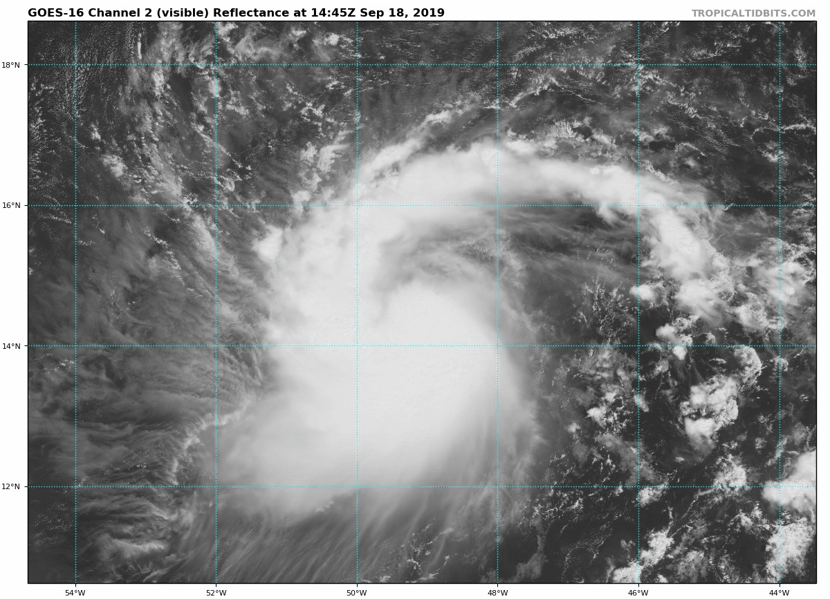
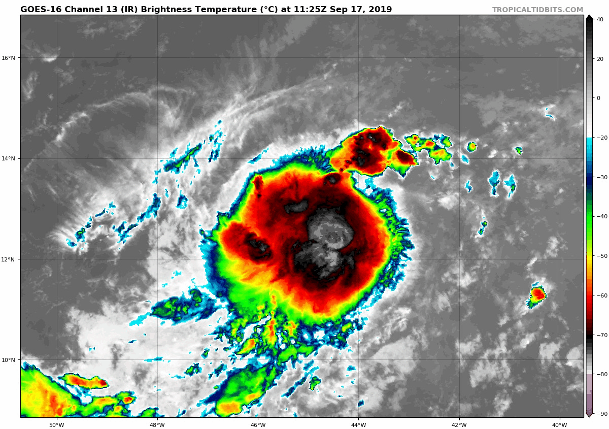
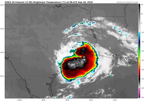
Regardez moi la petite bombe atomique en plein centre, ou tout prêt... Cliquez...
-
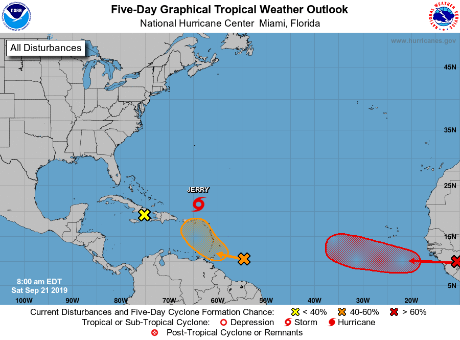
Et il y aura même un quatuor bientôt... avec 91C
-
Bonne journée à tous !
-
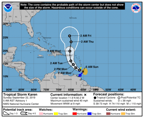
Oui mais il devait gagner en latitude pendant la nuit et ce n'est pas le cas... - espérons ! Et il est baptisé maintenant: "Jerry"
-
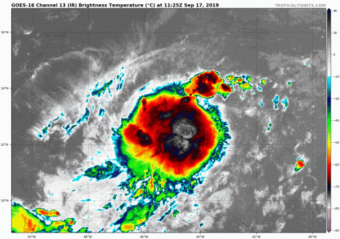
Imelda: Cliquez dessus ! Ou ICI: https://www.tropicaltidbits.com/sat/satlooper.php?region=11L&product=ir
-
DISCUSSIONS PRÉVISIONS du 16 au 22 sep 2019
Pooram a répondu à un(e) topic de beachcp31 dans Discussions générales
Voudrais tu insinuer que les Montréalais pensent comme des nombrils... ? ---------------------- -
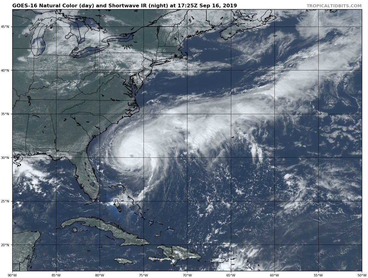
Le Texans on la peur au ventre... Mesoscale Precipitation Discussion 0860 NWS Weather Prediction Center College Park MD 442 PM EDT Tue Sep 17 2019 Areas affected...Upper Texas Coast Concerning...Heavy rainfall...Flash flooding possible Valid 172041Z - 180241Z Summary...As Tropical Storm Imelda continues to slowly drift further inland, there will be an increasing threat of flash flooding into the evening hours on the Upper Texas Coast. This may include portions of the Houston Metro Area. Discussion...There are two primary areas of concern for flash flooding associated with Tropical Storm Imelda as it continues to move inland late this afternoon and into the evening. The first area would be associated with tropical rain bands to the east of the track of the center, embedded within a ribbon of persistent, enhanced moisture flux and stronger low-level flow in the eastern semi-circle of the storm. Places around Galveston Bay would be the most likely to be impacted by these rain bands. The second area would be associated with increasing coastal convergence in the coastal counties of Matagorda, Brazoria and Galveston. Winds offshore would be likely to back slightly (increasing southerly component) and remain stronger relative to over-land winds as Imelda's center moves inland. This could increase convergence closer to the coast, and coincide with a slight increase in instability as more unstable air over the Gulf gets advected just onshore. The combination of low-level convergence and instability may support increasingly organized and stronger rain bands. Overall, these expectations align with numerical model predictions of the heaviest rain falling to the east and south of the center. Given the slow motion of Imelda (likely to move only about 50 miles in 9 hours based on the official NHC forecast), organized tropical rain bands may persist in these two areas for an extended period of time, which would lead to an increasing flash flood threat. Rain rates in the stronger rain bands would be likely to reach the 2-3 in/hr range, and could exceed that if stronger instability can develop onshore and coincide with low-level forcing mechanisms mentioned above. If that occurs, rain rates into the 3-5 in/hr range could occur on an isolated basis in the strongest, most organized rain bands. Several gages in southern Harris County near the Sam Houston Tollway and I-45 have measured 1.16 inches of rain in 30 minutes (20:00 to 20:30Z), and 5-minute rain rates have been as high as 0.36 inches. This is an early indicator of very high instantaneous rain rates in the tropical rain bands, but thus far the rain bands have been relatively narrow and transient relative to stationary locations. However, if larger rain bands can become established, more substantial hourly rain rates would be likely, and this would be more likely to have notable flash flood impacts. The concern for the overnight hours is if several inches of rain from early rain bands pre-condition the ground along the Upper Texas Coast this afternoon and early this evening, and then another burst of convection develops closer to Imelda's center overnight. Convection tends to concentrate closer to the center of circulation in the overnight period of the diurnal cycle, and this could enable additional heavy rain over areas that already received heavy rainfall earlier in the day. The NHC forecast also calls for the center to move very close to Houston by 06Z, which would place a potentially favored area for nocturnal convection directly over a major metro area. This will continue to be monitored into the evening hours. Lamers ATTN...WFO...CRP...HGX...LCH... ATTN...RFC...WGRFC... LAT...LON 30629511 30399453 29589427 29039473 28589552 28449632 28449633 28959641 29489602 30189564
-
Le GFS le fait tourner NO mais pas beaucoup aujourd'hui...
-
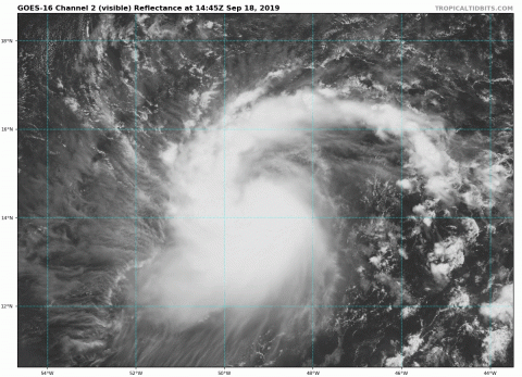
TS 10 en développement - Cliquez dessus ! Donc NHC a à faire à un trio maintenant dans l'Atlantique....
-
Merci Dave, UKMET sur Portorico... Je revient sur Humberto; finalement je pense que ce sera difficile d’atteindre une cat 3 ou 4 rapidement justement à cause de sa taille...
-
Ben oui ! Le HWRF; mais pourquoi étrange ? ma blonde me dit que j'ai l'air pensif... je lui ai répondue que pas vraiment, je suis plutôt absorbé, c'est étrange; quelqu'un sur le forum a justement mentionner qu'une trajectoire proposer par un modèle était étrange... et elle n'a rien dis en riant doucement; étrange n'est ce pas? bizard bizard...
-
Pour l'instant ça ressemble à rien, MAIS !

-
97L est a 90% maintenant dans 5 jours....
-
Cat. 3 dans 36hrs selon le NHC mais on peut envisager un 4 ... Il y aura sans doute un changement d'oeil pendant cette période et il est déjà de taille importante alors dans les majeurs certainement...
-
DISCUSSIONS PRÉVISIONS du 16 au 22 sep 2019
Pooram a répondu à un(e) topic de beachcp31 dans Discussions générales
D ailleurs, je me rend compte que l'article que j'ai mis dans ce sujet est une erreurs de ma part - et condamnable même je dirais étant donné la structure du forum... Mais ! Grands bravos à ceux qui y on répondu avec cet esprit de collaboration ...