Pooram
-
Compteur de contenus
6 197 -
Inscription
-
Dernière visite
-
Jours gagnés
141
Type de contenu
Profils
Forums
Events
Gallery
Tout ce qui a été posté par Pooram
-

Observations du 30 sep au 6 oct 2019
Pooram a répondu à un(e) topic de beachcp31 dans Discussions générales
C'était super ! -
Observations du 30 sep au 6 oct 2019
Pooram a répondu à un(e) topic de beachcp31 dans Discussions générales
Beaucoup d'eau ! ça ressemble à juillet 1984.... -
Observations du 30 sep au 6 oct 2019
Pooram a répondu à un(e) topic de beachcp31 dans Discussions générales
Et le final avec vent du NNO - l'orage ! Ça commence à barder dans le sud de L'Iowa... -
Observations du 30 sep au 6 oct 2019
Pooram a répondu à un(e) topic de beachcp31 dans Discussions générales
Ça se poursuit en se transformants en ondées courtes et orages Foudre puissante et soutenue en ce moment. vent du SO plus tôt puis du NE en petites rafales -
Observations du 30 sep au 6 oct 2019
Pooram a répondu à un(e) topic de beachcp31 dans Discussions générales
Oui le tonnerre très éparse et la pluie depuis 15h05 -
Observations du 30 sep au 6 oct 2019
Pooram a répondu à un(e) topic de beachcp31 dans Discussions générales
Cellules en approches sur mon secteur - -
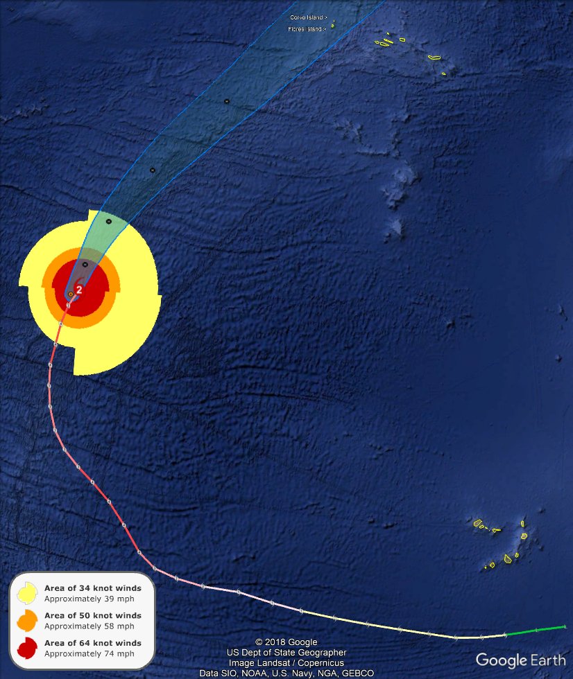
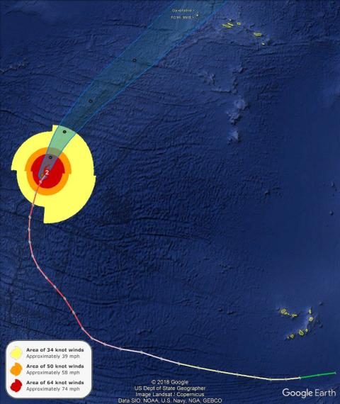
Les deux petites Îles des Açores; Flores et Corvo qui est sur la trajectoire de Lorenzo. https://en.wikipedia.org/wiki/Corvo_Island Et la trajectoire UNIQUE de Lorenzo à droite complètement, à être cat 4 deux fois... ( ...de 1851 à 2019 )

-
Si y a quelque chose dans les prochains jours; ça va se jouer dans les Caraïbes sans doute.
-
Juste a mention...
-
https://fr.wikipedia.org/wiki/A%C3%A7ores Les Açores... Que Dieu protège ce paradis...
-
Observations du 23 au 29 sep 2019
Pooram a répondu à un(e) topic de beachcp31 dans Discussions générales
Oui j'ai eu de bonnes averses aujourd'hui. Quelques flashes actuellement 20h30 Ajout; 21h15: orage St Marc sur Richelieu ----- ailleurs aussi dans cette régions -
yoyoy ! 932
-
Le XTRP l'envoie sur la côte E US
-
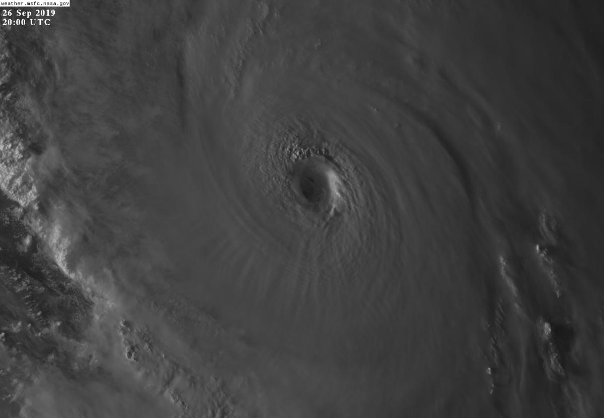
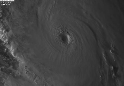
Bien... Lorenzo: Quelque chose d'historique sans doute étant donné la zone ou il se trouve - attention sur son chemin et possiblement la Gr Bretagne...
-
Lorenzo et L'Atlantique en gif Clic !
-
Lorenzo; Le Lion. Les Azores sont dans la mire - un autre Bahamas drama ?

-
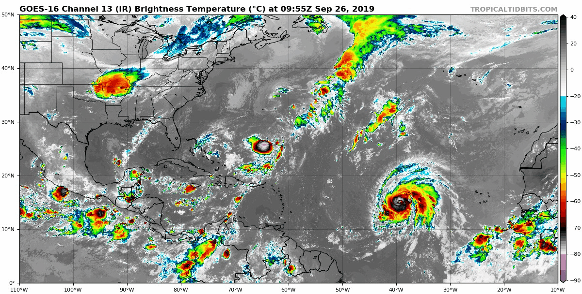
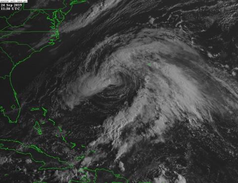
De toute façons Karen va survivre !!! L'interaction entre les deux va cesser avec la mort de Jerry et même que Karen va pouvoir se nourrir des restes de Jerry - j'ai les larmes aux yeux Un beau suicide...
-
Pour Karen bien il y a une sérieuse et intéressante interaction avec Jerry. Quelqu'un peux expliquer çà ? Dave, Alain, Erick ???
-
Lorenzo: En bonne forme mais il pourrait y avoir intrusion d'air sec dans le cadran N; ce qui retarderait un peu sa croissance et la trajectoire NO le gardant plus longtemps au Sud

-
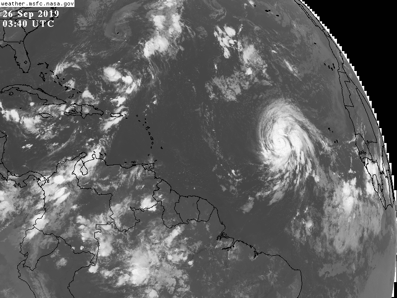
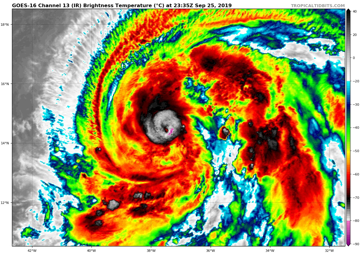
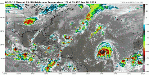
Par contre Lorenzo c'est une autre histoire ... Tropical Storm Lorenzo Discussion Number 6 NWS National Hurricane Center Miami FL AL132019 500 AM AST Tue Sep 24 2019 Satellite images indicate that the cloud pattern associated with Lorenzo continues to become better organized, with many curved bands and a newly formed central dense overcast. In fact, an overnight AMSR2 microwave pass showed that Lorenzo already had a very small central core. The initial wind speed is raised to 55 kt, in accordance with the latest TAFB classification. Conditions seem to be ripe for further intensification given that the storm is over fairly warm waters, with humid mid-level air, and weak/moderate shear. The SHIPS Rapid Intensification index is giving a 53 percent chance of Lorenzo intensifying 25 kt during the next 24 hours, which seems very reasonable since it now has a tight inner core, and after noting the storm just strengthened 25 kt during the previous 24 hours. Thus the intensity forecast is raised from the last one, showing the initial period of very quick strengthening, and is at the upper edge of the guidance. It is worth noting that all of the global models show Lorenzo becoming a fairly large and powerful hurricane within the next 5 days, and the new wind radii forecast reflects this likelihood. The storm is moving west-northwestward at about 14 kt. This general course is expected for the next couple of days while Lorenzo moves beneath the eastern Atlantic subtropical ridge. A break in the ridge should occur in a few days over the central Atlantic, causing the tropical cyclone to turn northwestward and north-northwestward over the weekend. The new forecast is shifted slightly northward in the short term, but is close to the previous NHC prediction thereafter, closest to the corrected-consensus aids. FORECAST POSITIONS AND MAX WINDS INIT 24/0900Z 12.0N 28.0W 55 KT 65 MPH 12H 24/1800Z 12.6N 30.0W 65 KT 75 MPH 24H 25/0600Z 13.3N 32.7W 80 KT 90 MPH 36H 25/1800Z 13.9N 35.5W 90 KT 105 MPH 48H 26/0600Z 14.4N 38.0W 95 KT 110 MPH 72H 27/0600Z 17.0N 41.7W 100 KT 115 MPH 96H 28/0600Z 20.0N 44.5W 105 KT 120 MPH 120H 29/0600Z 23.0N 46.0W 105 KT 120 MPH $$ Forecaster Blake
-
Jerry est mourant mais... Mais quoi ? en fait il est très possible que Karen et Jerry passent au registre de la morgue !
-
Non on le savait pas bon ! ------------------------------------------- fatiguant ------------------------------------
-
Non en fait Lorenzo n'existe pas encore; cette entité est dépression tropicale 13 au moment ou j'écris. Deviendra El Lorenzo dans les prochaines heures, peut être bien même la prochaine et deviendra rapidement ouragan puissant ... https://rammb-slider.cira.colostate.edu/?sat=goes-16&z=3&im=12&ts=1&st=0&et=0&speed=130&motion=loop&map=1&lat=0&opacity%5B0%5D=1&hidden%5B0%5D=0&pause=0&slider=-1&hide_controls=0&mouse_draw=0&follow_feature=0&follow_hide=0&s=rammb-slider&sec=full_disk&p%5B0%5D=band_02&x=19841.400390625&y=8825.33349609375
-
Observations du 16 au 22 sep 2019
Pooram a répondu à un(e) topic de beachcp31 dans Discussions générales
Température : 24,3°C à 22h15 -
Il sort de L'Afrique avec un nom; çà dit tout !!!