Pierre
-
Compteur de contenus
5 703 -
Inscription
-
Dernière visite
Type de contenu
Profils
Forums
Events
Gallery
Tout ce qui a été posté par Pierre
-
Intellicast ne donne pas de neige d'ici 19h00 demain soir .....sur nos régions... En tout cas ce matin....
-
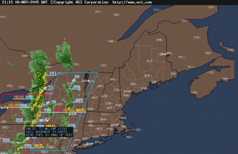
Le radar MCGill indique que les premiers orages pourraient se faire sentir vers 18h45 sur l'extrême ouest de l'Île de Montréal....si bien sûr cette ligne maintient cette allure .....
-
À 16h48 Ottawa à enregistré un second orage fort avec cette fois-ci des rafales à 70 km/h voir observation à Ottawa ...en tableau.
-
Le détecteur à 17h02 à atteint 11 éclairs minutes.....un sommet aujourd'hui
-
MÉSO ........ Pourtant en tant que chasseur d'orages tu sais qu'une ligne se fait et se défait au gré de son déplacement.....Ça fait deux fois que tu mentionne ça aujourd'hui et quelques minutes après ton message la ligne est de nouveau intense.... :P
-
beaucoup de meso juste au sud.....
-
The National Weather Service in Burlington has issued a * Severe Thunderstorm Warning for... St. Lawrence County in northern New York * until 530 PM EST. * At 356 PM EST... National Weather Service Doppler radar indicated a line of severe thunderstorms from 37 miles northwest of Morristown New York to around 40 miles southwest of Chippewa Bay... moving northeast at 55 mph. * Severe thunderstorms will be... near Morristown... Chippewa Bay around 450 PM EST... near Ogdensburg... Hammond... Edwardsville around 5 PM EST... near Gouverneur... Fowler around 510 PM EST... near Rensselaer Falls... Wanakena... Star Lake around 520 PM EST. These are dangerous storms. Prepare for damaging winds or large hail. Seek indoor shelter... away from windows. Severe thunderstorms can produce tornadoes with little warning. Stay tuned to NOAA Weather Radio... commercial television and radio... or your cable television provider for weather updates. Lat... Lon 4460 7566 4479 7541 4478 7541 4484 7529 4499 7488 4499 7474 4496 7474 4494 7466 4447 7461 4412 7456 4406 7503 4413 7524 4431 7565 4439 7582 VTEC:/O.NEW.KBTV.SV.W.0065.051106T2105Z-051106T2230Z/ Severe Thunderstorm Watch urgent - immediate broadcast requested Severe Thunderstorm Watch number 851 NWS Storm Prediction Center Norman OK 400 PM EST sun Nov 6 2005 The NWS Storm Prediction Center has issued a Severe Thunderstorm Watch for portions of Far northern New Jersey eastern New York east central and northeast Pennsylvania far western Vermont Lake Ontario Effective this Sunday afternoon and evening from 400 PM until 1000 PM EST. Hail to 1 inch in diameter... thunderstorm wind gusts to 80 mph... and dangerous lightning are possible in these areas. The Severe Thunderstorm Watch area is approximately along and 65 statute miles east and west of a line from 40 miles north northeast of Saranac Lake New York to 25 miles west southwest of Allentown Pennsylvania. For a complete depiction of the watch see the associated watch outline update (wous64 kwns wou1). Remember... a Severe Thunderstorm Watch means conditions are favorable for severe thunderstorms in and close to the watch area. Persons in these areas should be on the lookout for threatening weather conditions and listen for later statements and possible warnings. Severe thunderstorms can and occasionally do produce tornadoes. Other watch information... continue... ww 850... Discussion... line of thunderstorms will continue ewd across ww this evening associated with very strong/deep ascent from potent shortwave trough lifting into the northeastern U.S. Though instability will remain rather weak... MUCAPE appears sufficient to maintain line or broken line of thunderstorms. Shear is quite strong and will support supercells and small Bow echoes. Damaging winds can be expected with the stronger cells.Aviation... a few severe thunderstorms with hail surface and aloft to 1 inch. Extreme turbulence and surface wind gusts to 70 knots. A few cumulonimbi with maximum tops to 500. Mean storm motion vector 24045. ... Evans
-
Ottawa et Gatineau ont rapporté des orages forts à 15h00... et une deuxième ligne plus intense s'est reformé à l'arrière .....
-
J'ai remis le détecteur de Joliette en fonction ...... Il rapporte un peu d'activité à l'ouest , mais c'est encore trop loin .... Une ligne d'orage touche actuellement l'est de l'Ontario et elle se déplace nord-est très rapidement (presque 100 km/h) !!!! Je pense qu'on doit s'attendre a de fortes rafales pour chaque orages qui se développera sur nos secteurs aujourd'hui....
-
Une journée passablement mouvementée....possible ! Expires 08:00 EST le 06 novembre 2005 Statement as of 05:51 EST le 06 novembre 2005 ... Strong to severe thunderstorms possible over portions of the north country this afternoon and evening... A cold front will move through the north country this afternoon into the evening hours. Some strong thunderstorms are possible to occur as this front moves east. These storms may produce damaging winds that may knock down trees and power lines. Stay tuned to NOAA Weather Radio or your local media for the later updates on this situation.
-
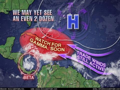
Le système n'a pas perdu de force .... Faut faire attention avec les milles à l'heure et les kilomètres heure Le système est à son plus fort actuellement et très près d'être ouragan.... Le vent souffle à 105 km/h de façon soutenue Storm Coordinates Tracking info for Tropical Storm Beta Time Lat Lon Wind(mph) Pressure Storm type ------------------------------------------------------------------------ 03 GMT 10/27/05 11.1N 81.5W 35 1006 Tropical Depression 09 GMT 10/27/05 11.4N 81.8W 40 1005 Tropical Storm 15 GMT 10/27/05 11.5N 81.3W 50 1000 Tropical Storm 21 GMT 10/27/05 11.7N 81.4W 60 997 Tropical Storm 03 GMT 10/28/05 12.1N 81.4W 65 994 Tropical Storm 09 GMT 10/28/05 12.3N 81.2W 65 994 Tropical Storm 15 GMT 10/28/05 12.9N 81.2W 65 993 Tropical Storm
-
Je pense bien qu'on aura droit à une catégorie 2 ou 3 avec BETA à cause de son lent déplacement ....Ça pourrait toutefois lui nuire si elle fait du sur place plus de 24 heures ....à cause du refroidissement de l'eau en dessous d'elle ! Voici qu'AW parle déjà de GAMMA
-
La tempête Alpha en formation...?
Pierre a répondu à un(e) topic de Pierre dans Discussions générales
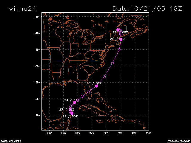
Alpha a pris naissance le 22 octobre est a été officiellement absorbée par Wilma le 24 octobre ...Le maximum des vents a été de 50 mph et elle a été tempête tropicale pendant 12 à 18 heures ..... En passant il semble y avoir un autre bon prospect encore une fois dans la mer des Caraibes....Beta suivra peut-être sous peu.... -
Scénario potentiellement catastrophique ?!
Pierre a répondu à un(e) topic de Pierre dans Discussions générales
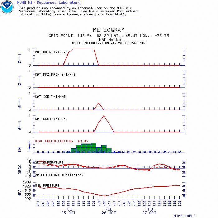
À 18z le NAM maintient le cap....Neige presque partout dans le sud du Québec dans la nuit de mardi à mercredi et/ou tôt mercredi. Voici la prévision NAM 18z pour Montréal.....
-
Scénario potentiellement catastrophique ?!
Pierre a répondu à un(e) topic de Pierre dans Discussions générales
Le NAM donne ces quantités de neige .....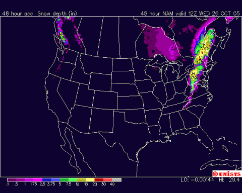
-
Scénario potentiellement catastrophique ?!
Pierre a répondu à un(e) topic de Pierre dans Discussions générales
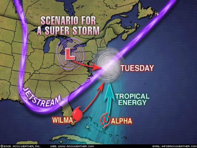
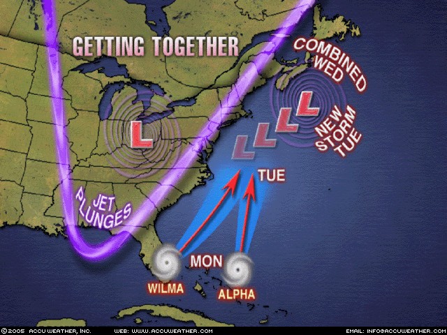
Discussion prise sur AW ce soir..... The atmosphere holds the potential for the development of a powerful super storm off the Atlantic Seaboard of the United States early next week. While this would be true to some extent without the existence of Hurricane Wilma and the former Tropical Storm Alpha, which represent a great reservoir of tropical warmth and moisture, it only ratchets up the potential. The key ingredients in bringing this storm together are twofold. First, a sharply dipping jet stream will be thrusting southward from central Canada and tapping a cold pool to spin up low pressure south of the Great Lakes Monday. The other player, Hurricane Wilma, will cross the Florida Peninsula Monday. It is Monday night and Tuesday when things could get crazy in the meteorological sense. The strong northeast-trending jet stream will scoop up Wilma, with the contribution of energy from Alpha in the form a warm, moist tropical air. At the same time, the low over the Midwest shifts to the coast. As Wilma tracks north just off the East Coast, the storm may be close enough to draw in the cool low from the west and an explosive deepening could result, culminating in a deep and fully merged storm raging off the mid-Atlantic coast Tuesday. This would result in gale force winds along the immediate East Coast with heavy rain farther inland and even snow in the mountains of New England.
-
Scénario potentiellement catastrophique ?!
Pierre a répondu à un(e) topic de Pierre dans Discussions générales
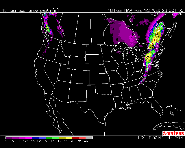
Voici la prévision pour la Montérégie.....NAM 18 Z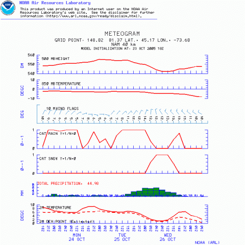
-
Scénario potentiellement catastrophique ?!
Pierre a répondu à un(e) topic de Pierre dans Discussions générales
Bien qu'il y ait possibilité de neige dans la nuit de mardi à mercredi ...Je pense que les accumulations seront surtout pour les secteurs montagneux .... Néanmoins ..... Le NAM rejoint maintenant le GFS avec de 20 à 40 mm de précipitation débutant mardi. Noter que le NAM donne environ 9 heures de neige fondante dans la nuit de mardi à mercredi pour un équivalent d'eau de 5 à 10 mm. Ça pourrait être blanc par endroit mercredi matin..... -
Scénario potentiellement catastrophique ?!
Pierre a répondu à un(e) topic de Pierre dans Discussions générales
et voilà.....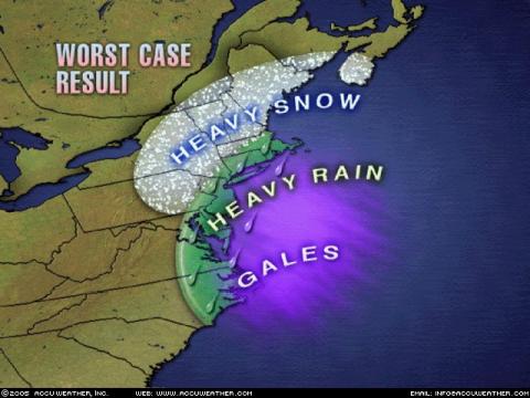
-
Scénario potentiellement catastrophique ?!
Pierre a répondu à un(e) topic de Pierre dans Discussions générales
tu veux vraiment le savoir.....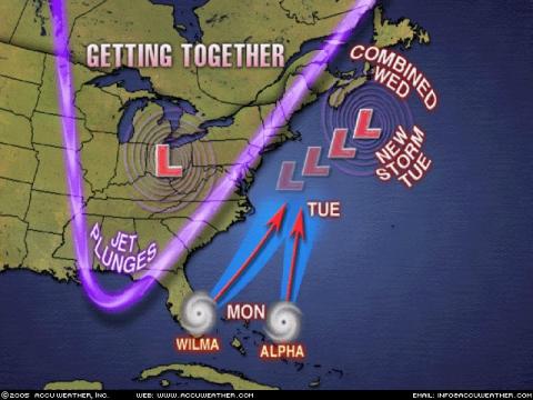
-
Scénario potentiellement catastrophique ?!
Pierre a répondu à un(e) topic de Pierre dans Discussions générales
En tout cas les modèles 0z (GFS NOGAPS et GEMGB ) montrent bien le rapprochement de la zone de pluie sur nos régions ....On parle de 20 à 40 mm pour le moment avec les restes de Wilma (Montérégie Montréal lanaùdière) ....Mais la trajectoire dépend de plusieurs facteurs encore. Elle touchera la Floride à quelle hauteur (sud ou centre ?) et a quelle intensité ? Après ça , ça demeure encore hypothétique....Les modèles sont très changeants même à moins de 4 jours avant l'évenement. Mais c'est à suivre de près..... -
Scénario potentiellement catastrophique ?!
Pierre a répondu à un(e) topic de Pierre dans Discussions générales
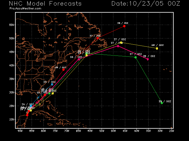
Voici le reste de la modélisation avec les modèles plus spécialisés....00Z23 oct En vert ....BAMD En jaune...BAMM En Bleu...LBAR En rouge.... A98E En fushia....la moyenne Tout ces modèles étaient plus à l'est hier soir.....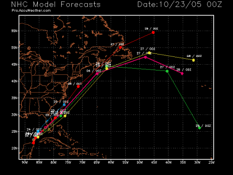
-
Scénario potentiellement catastrophique ?!
Pierre a répondu à un(e) topic de Pierre dans Discussions générales
Voici les nouvelles trajectoires..... Hier le GFDL montrait un rapprochement vers le Québec , ce soir le GFS se joint au GFDL et est même carément au Québec avec plus de 100 mm par endroit.... Avec l'accélération de Wilma vers le nord et nord-est au cours des prochaines heures les prévisions se préciseront peu à peu pour le sud du Québec .....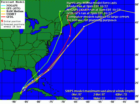
-
Scénario potentiellement catastrophique ?!
Pierre a répondu à un(e) topic de Pierre dans Discussions générales
Voici la nouvelle Prévision du GFDL..... Cette carte vient d'Accuweather professional.....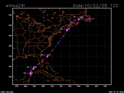
-
Scénario potentiellement catastrophique ?!
Pierre a répondu à un(e) topic de Pierre dans Discussions générales
..voici le dernier GFDL....