uranium
-
Compteur de contenus
2 065 -
Inscription
-
Dernière visite
-
Jours gagnés
11
Type de contenu
Profils
Forums
Events
Gallery
Tout ce qui a été posté par uranium
-
OBSERVATIONS TEMPÊTE MAJEURE du 13 et 14 février 2014
uranium a répondu à un(e) topic de dave20 dans Discussions générales
Je suis en direction sur la 73 en partance de Stoneham,chez nous nous etions ds un trou de radar, mais 7km plus au sud, neige moderee. Toutes les commissions scolaires sont fermees a Quebec et Chaudiere-Appalache. -
OBSERVATIONS TEMPÊTE MAJEURE du 13 et 14 février 2014
uranium a répondu à un(e) topic de dave20 dans Discussions générales
Ici, trace de tombee, nuageux, vents 20 a 25. -5. -
Discussion tempête du 13 et 14 février, sud du fleuve, centre du Québec, est et Maritimes
uranium a répondu à un(e) topic de dave20 dans Discussions générales
Extrait du forecast discussion (NOAA) ... Today's'observationnal trends have suggested that this system will take a slightly further WESTWARD track then previously expected. -
Discussion tempête du 13 et 14 février, sud du fleuve, centre du Québec, est et Maritimes
uranium a répondu à un(e) topic de dave20 dans Discussions générales
Oui Dave. Chez nous, ce que je remarque souvent est l'effet de vallee versus le vent. Souvent ils sont beaucoup plus legers comparativement aux previsions pour Quebec. Je demeure en face de la Station de skis donc vraiment dans le fond d'une vallee. Je ne crois pas que ca sera si fort cote poudrerie car la force du soleil a fait sont oeuvre sur la neige et cela a durcit la surface. A moins qu'il tombe 10 cm cette nuit avec pas trops de vent et qu'il se leve demain matin... Watch out. -
Discussion tempête du 13 et 14 février, sud du fleuve, centre du Québec, est et Maritimes
uranium a répondu à un(e) topic de dave20 dans Discussions générales
Temperature a 850hpa (5000 pieds) : Pour la nuit prochaine, l'ECMWF montre un court episode avoisinant le zero pour l'Estrie. L'UKMET est un peu plus froid. Je crois pas qu'il y a matiere a s'inquieter. Pour ma region, ca risque d'etre assez venteux. L'alignement des isobares semble optimal pour generer de bonnes rafales sur Quebec surtout demain tres tôt en matinee. -
Discussion tempête du 13 et 14 février, sud du fleuve, centre du Québec, est et Maritimes
uranium a répondu à un(e) topic de dave20 dans Discussions générales
Mon intuition était bonne pour les passes de 00z. L'intensification a fait la différence. -
Discussion tempête du 13 et 14 février, sud du fleuve, centre du Québec, est et Maritimes
uranium a répondu à un(e) topic de dave20 dans Discussions générales
Très hâte de voir les sorties de 00z. -
DISCUSSIONS PRÉVISIONS du 10 au 16 fév 2014
uranium a répondu à un(e) topic de Trapper dans Discussions générales
Il pourrait revenir sur les écrans radars d'ici la fin de semaine, tout n'est pas encore joué. -
DISCUSSIONS PRÉVISIONS du 3 au 9 fév 2014
uranium a répondu à un(e) topic de Trapper dans Discussions générales
Potentiel d'un Nor'easter pour les 10 et 11. -
Copier/coller des infos car l'insertion du lien ne fonctionne pas..anyway. Weather Model Différences between the GFS (American) and ECMWF (European) Posted At : January 6, 2014 10:27 PM | Posted By : Ria Persad Most energy professionals receive weather information stemming from government models. The two government numerical weather prediction models most commonly employed in the U.S. energy markets are the GFS (American) and the ECMWF (European) ensembles. I receive many questions on the differences between these two models, so after a long literature search, corroborated by my own experience, I compiled this quick reference for energy professionals and weather enthusiasts. These generalities will not work every time, as there will be exceptions, but I have done my best to summarize the most current findings from a number of prominent scientists. If you are aware of new or different information than what is here, please feel free to email me at rpersad@statweather.com and I will update this list. If you are interested in long-range prediction models (beyond the 16-day range of the GFS and ECMWF ensembles), please go to WWW.STATWEATHER.COM to learn more about long-range forecasting. DIFFERENCE BETWEEN THE GFS (American) AND ECMWF (European) MODELS - Northern Hemisphere MAXIMUM SKILL RANGE (WHEN MODELS ARE BETTER THAN CLIMATE NORMALS) GFS: Days 1 to 8 (Summer and Fall) and Days 1 to 9 (Winter and Spring). ECMWF: One more day than GFS. Implication: GFS’s accuracy is similar to that of yesterday’s ECMWF model run. Reason: ECMWF is run at higher resolution, with better observational data and statistical post-processing. PATTERN SHIFTS GFS does a good job of predicting pattern shifts 37% of the time. ECMWF does a good job of predicting pattern shifts 61% of the time. (“Good job” means anomaly correlation coefficient of 0.9 or better, skillful at synoptic changes.) After 5 days, the GFS will tend to only detect large scale pattern shifts. After 6 days, the GFS will tend to only detect the very largest scale global pattern shifts. ECMWF is half a day ahead at catching synoptic pattern shifts and is more accurate. WINTER WEATHER SKILL 1 Day Ahead: GFS is better 2 Days Ahead: Average of GFS and ECMWF is best Days 3 and Beyond: ECMWF has higher skill YEAR ROUND SKILL (IN GENERAL) Days 1 to 5: GFS and ECMWF are comparable Days 6 and on: ECMWF significantly higher skill (gap between the 2 models increases substantially) SEASONALITY Greatest model errors for GFS and ECMWF are in Winter, which are double the errors in Summer. ECMWF is ~10% more accurate than GFS in Summer months and ~20% more accurate in Winter months. MODEL QUIRKS GFS • Once a month, GFS has “dropouts”, where the forecast is a major fail, a major outlier, and very divergent from the ECMWF, which does not have dropouts. GFS scientists are trying to fix dropouts through better initializations. One proposal is to use ECMWF initializations (better quality satellite observations), which would lower dropouts by 90%, but solutions are taking time. • Can run a cold bias in the Eastern U.S. (but OK in the West). • Ensembles can be over-confident (low ensemble spreads can still have low forecast accuracy). • Tends to have a warm bias in the upper troposphere. • Tends to have a cold bias for afternoon temperatures during warm months. ECMWF • Tends to underestimate heavy precipitation events, but GFS has no such bias. • Tends to have greater model bias; GFS tends to have greater model absolute error. • Tends to have a cold bias in the stratosphere. • Tends to have a warm bias for morning temperatures. DIFFERENCE BETWEEN GFS (OPERATIONAL) and GFS (ENSEMBLE) GFS Operational is run at a higher resolution (more precision) than the GFS Ensemble. The GFS Ensemble uses as its “control” or “base run” a low resolution (watered-down) version of the GFS Operational run (to save on computing resources), then perturbs or varies this control “base run” slightly to produce the various members of the ensemble. As a result, sometimes the GFS Operational is different from the GFS Ensemble…and can even be more accurate at times. In general, use the ECMWF as an indicator as to whether to lean more heavily to the GFS Operational or the GFS Ensemble. REFERENCES Alpert J, Carlis D, Ballish B, Kumar VK. NCEP GFS Forecasts From ECMWF Analysis. American Meteorological Society Supported Meeting; 2012 Breivik Ø, Aarnes OJ, Abdalla S, Bidlot JR. Wind and Wave Extremes over the World Oceans From Very Large Forecast Ensembles. Proceedings of the 13th International Workshop on Wave Hindcasting. Banff, Canada; 2013 Buizza R, Houtekamer P, Pellerin G, Toth Z, Zhu Y, Wei M. A Comparison of the ECMWF, MSC, and NCEP Global Ensemble Prediction Systems. Monthly Weather Review. 2005; 133, 1076–1097 Curry J. U.S. Weather Prediction: Falling Behind. www.judithcurry.com. 2012 Fan Y, Van Den Dool H. Bias Correction and Forecast Skill of NCEP GFS Ensemble Week-1 and Week-2 Precipitation, 2-m Surface Air Temperature, and Soil Moisture Forecasts. Weather and Forecasting. 2011; 26: 355-370 Hotta D, Kalnay E, Ota Y, Miyoshi T. Ensemble Forecast Sensitivity to Observations (EFSO) and Proactive Quality Control. Cooperative Institute for Climate and Satellites, University of Maryland; 2013 Kumar VK, Ballish BA, Jacobs S, Kempisty K, Guan S. NCEP GFS forecast divergence versus ECMWF. 92nd Annual American Meteorological Society Meeting; 2012 Kumar VK, Alpert JC, Carlis DL, Ballish BA. A Sensitivity Study of the November 25, 2011 GFS Dropout Using the GSI Hybrid EnKF vs GSI 3DVAR. 92nd Annual American Meteorological Society Meeting; 2013 La Rue JA. Comparing Numerical Model's Days 3, 4, 5 and 6. National Weather Association; 2001 Pegion P, Whitaker J, Hamill T. A Comparative Evaluation of NCEP and ECMWF Methods for Estimating Model Uncertainty. Meeting of the National Centers for Environmental Prediction; 2012 Petersen D, Brill K, Novak D, Hogsett W, Klein M. WPC Winter Weather Desk Operations and Verification; 2013-2014 Yang F. NCEP/EMC Global Model Experimental Forecast Performance Statistics. http://www.emc.ncep.noaa.gov. 2014 Yang F. Review of GFS Forecast Skills in 2012. IMSG - Environmental Modeling Center, National Centers for Environmental Prediction Yang F. Review of NCEP GFS Forecast Skills in 2011 and Beyond. The 46th CMOS Congress and the AMS 21th NWP and 25th WAF conferences. Montréal (Canada); 2012 Yang F. GFS Forecast Verification. NEMS/GFS Modeling Summer School 2013. Environmental Modeling Center National Centers for Environmental Prediction. College Park, Maryland
-
DISCUSSIONS PRÉVISIONS du 20 au 26 jan 2014
uranium a répondu à un(e) topic de Trapper dans Discussions générales
Hé bien NY et les alentours vont essuyer une bonne bordée demain avec des vents quand même respectables, 15 à 20 cm en gros. -
Observations du 13 au 19 jan 2014
uranium a répondu à un(e) topic de Trapper dans Discussions générales
-16 présentement, vents légers, +ou- 17 cm de nouvelle neige. -
Observations du 13 au 19 jan 2014
uranium a répondu à un(e) topic de Trapper dans Discussions générales
Déjà -20 en Abitibi à la faveur de vents en provenance du ONO, sous avertissement de refroidissement éolien. -6 ici, on attend le front tard en soirée, vents du SSO très légers, on ira chercher près de 15 cm certain, il neige toujours depuis plusieurs heures, tantôt abondamment, tantôt légèrement. -
DISCUSSIONS PRÉVISIONS du 13 au 19 jan 2014
uranium a répondu à un(e) topic de Trapper dans Discussions générales
On voit très bien le front froid présentement en Abitibi via la carte radar. Les vents avoisinent les 70km/h à 850Hp. L'appel d'air arctique est significatif au niveau de la Baie-James. -
Observations du 13 au 19 jan 2014
uranium a répondu à un(e) topic de Trapper dans Discussions générales
Bourrasque de neige présentement, visibilité vraiment réduite. -
Observations du 13 au 19 jan 2014
uranium a répondu à un(e) topic de Trapper dans Discussions générales
On atteindra le 10 cm d'ici ce soir, le temps était idéal pour la coupe du monde FIS. Neige parfois modérée, vents légers. -
DISCUSSIONS PRÉVISIONS du 6 au 12 jan 2014
uranium a répondu à un(e) topic de Trapper dans Discussions générales
Bon matin Mistral, je risquerais une reponse en te disant que le dernier systeme était plus intense que celui qui s'amene, de un, et qu'il était plus pres de la cote. Donc cela pourrait expliquer qu'il était plus "humide". My 2 cents. -
Observations du 6 au 12 jan 2014
uranium a répondu à un(e) topic de Trapper dans Discussions générales
-16 de prevu comme minimum, je doute que le mercure descende jusque la avec un couvert nuageux quasi complet et des vents OSO. Le mercure a stagne a -11 entre 15h et 21:30. Il fait -12 actuellement. -
Observations Tempête de mélanges 5-6 janvier
uranium a répondu à un(e) topic de erol dans Discussions générales
Pluie moderee ici depuis tres tôt ce matin, pas de vents (- de 10 km/h), 12 cm tombes cette nuit. Des marres d'eau sont apparues dans les rues. -
DISCUSSION TEMPÊTE DE MÉLANGE 5-6 JANVIER
uranium a répondu à un(e) topic de Pierre dans Discussions générales
Le centre est maintenant au sud d'Indianapolis, c'est assez intense comme incursion d'air froid à l'arrière de la dépression. -
DISCUSSION TEMPÊTE DE MÉLANGE 5-6 JANVIER
uranium a répondu à un(e) topic de Pierre dans Discussions générales
Bon nombre de pannes d'électricité demain après-midi pour la région de Québec sont bien possibles avec la quantité de verglas à venir et les vents. -
DISCUSSION TEMPÊTE DE MÉLANGE 5-6 JANVIER
uranium a répondu à un(e) topic de Pierre dans Discussions générales
Quelqu'un peut m'expliquer comment insérer un lien? l'outil link ne fonctionne pas. -
DISCUSSION TEMPÊTE DE MÉLANGE 5-6 JANVIER
uranium a répondu à un(e) topic de Pierre dans Discussions générales
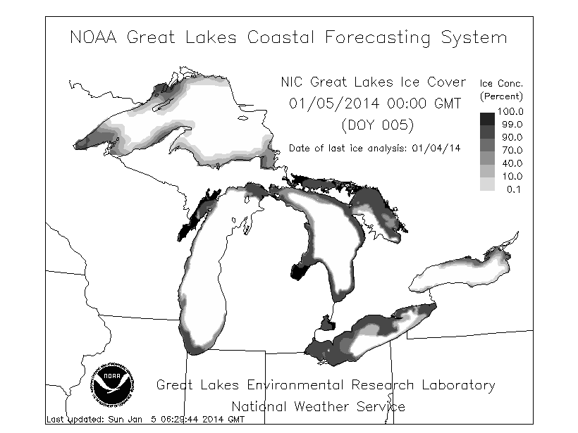
Effets de lac majeurs à venir avec l'incursion d'air arctique qui suit tout juste derrière. Les lacs ont pas mal de surfaces d'eau libre.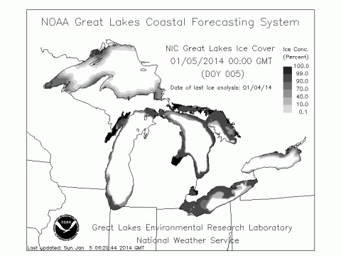
-
DISCUSSION TEMPÊTE DE MÉLANGE 5-6 JANVIER
uranium a répondu à un(e) topic de Pierre dans Discussions générales
Le GEM-REG semble développer un 2e low à 27h. Peu d'incidence je crois. -
DISCUSSION TEMPÊTE DE MÉLANGE 5-6 JANVIER
uranium a répondu à un(e) topic de Pierre dans Discussions générales
Cocktail d'avertissements pour la grande région de Québec, celui de pluie vient de s'ajouter. De mémoire, je dirais que c'est la première fois que je vois ça.