uranium
-
Compteur de contenus
2 065 -
Inscription
-
Dernière visite
-
Jours gagnés
11
Type de contenu
Profils
Forums
Events
Gallery
Tout ce qui a été posté par uranium
-
Observations - 18-19-20 Février 2009
uranium a répondu à un(e) topic de emixam101 dans Discussions générales
zéro pile ici, les vents sont modérés maintenant et tendent à augmenter. Faible neige. -
Observations - 18-19-20 Février 2009
uranium a répondu à un(e) topic de emixam101 dans Discussions générales
zéro degré atteint. Faible neige, vents légers. -
Observations - 18-19-20 Février 2009
uranium a répondu à un(e) topic de emixam101 dans Discussions générales
-0,5 celsius maintenant, neige, vents légers. -
Observations - 18-19-20 Février 2009
uranium a répondu à un(e) topic de emixam101 dans Discussions générales
Toujours -2,5, neige légère mais ça va s'intensifier dans peu de temps. près de 17 de neige fraîche. Les vents se lèvent de plus en plus, rafales modérées par moment. -
Bordée significative de neige ?
uranium a répondu à un(e) topic de Mistral21 dans Discussions générales
La région de Québec devrait être affectée par de bons vents à partir de ce midi. Le système côtier prend du tonus en ce moment et remonte. -
Observations - 18-19-20 Février 2009
uranium a répondu à un(e) topic de emixam101 dans Discussions générales
-2.5, faible neige, vents légers. 12 cm jusqu'à maintenant. -
Observations - 18-19-20 Février 2009
uranium a répondu à un(e) topic de emixam101 dans Discussions générales
Ça s'est intensifié dans les dernières minutes, neige modérée maintenant. -
Observations - 18-19-20 Février 2009
uranium a répondu à un(e) topic de emixam101 dans Discussions générales
Question de minutes pour votre secteur. -
Observations - 18-19-20 Février 2009
uranium a répondu à un(e) topic de emixam101 dans Discussions générales
Toujours -2, vents somme toute légers. Faible neige. -
Observations - 18-19-20 Février 2009
uranium a répondu à un(e) topic de emixam101 dans Discussions générales
Vents modérés, -2, nuageux. La neige est aux portes de Québec. -
Bordée significative de neige ?
uranium a répondu à un(e) topic de Mistral21 dans Discussions générales
Cela devrait être pas mal terminé de ton côté. Par contre, est-ce que les routes auront été bien dégagées, ça c'est une autre histoire. -
Observations - 18-19-20 Février 2009
uranium a répondu à un(e) topic de emixam101 dans Discussions générales
Couvert, -2, avec des vents qui se font de plus en plus présents. La neige devrait débuter vers les 21h00 ici. -
Bordée significative de neige ?
uranium a répondu à un(e) topic de Mistral21 dans Discussions générales
Bon matin à tous, EC a émis un avertissement de neige et de poudrerie pour Québec. 15 à 30 cm, c'est pas de refus! Je crois aussi qu'on aura droit à une bonne dose de vents. -
DISCUSSIONS ÉVÉNEMENTS du 2 au 8 février
uranium a répondu à un(e) topic de Trapper dans Discussions générales
Si tu observes bien la légende de la carte, tu es dans la zone de 1 à 3 pouces et non dans celle de 3 à 6. ** Modération: Merci de ne pas inclure d'image dans les citations lorsque vous répondez! *** -
DISCUSSIONS ÉVÉNEMENTS du 2 au 8 février
uranium a répondu à un(e) topic de Trapper dans Discussions générales
Nouvelle carte d'AW. On voit que les accumulations au Québec sont pour l'Estrie, La Beauce et Québec en allant vers l'est.
-
DISCUSSIONS ÉVÉNEMENTS du 2 au 8 février
uranium a répondu à un(e) topic de Trapper dans Discussions générales
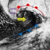
J'aime bien ce que je vois juste en bas. L'action se met en branle dans le Golf du Mexique et le sud-ouest Atlantique.
-
DISCUSSIONS ÉVÉNEMENTS du 2 au 8 février
uranium a répondu à un(e) topic de Trapper dans Discussions générales
J'ai un peu tendance à penser comme toi - d'attendre que le système se forme pour voir ce qu'il va se passer . Sauf que faut pas oublier que les conditions pour qu'un système se dévelloppe, elles se forment bien avant que le premier nuage apparaisse. Ce sera un système côtier il ne fait aucun doute maintenant - légèrement au large de la côte, mais tout de même une grosse tempête là où ça va passer. Parlez-en aux pêcheurs en haute mer, c'est la panique pour faire une dernière levée et revenir au port, ou s'éloigner très loin au large pour ne pas se faire frapper de plein fouet. Il faut surveiller à quel endroit le deuxième centre dépressionnaire se formera. L'ECMWF le place près des côtes de la Caroline du Nord. Cela pourrait changer la donne du tout au tout. -
DISCUSSIONS ÉVÉNEMENTS du 2 au 8 février
uranium a répondu à un(e) topic de Trapper dans Discussions générales
Malgré ce que je lis, je demeure quand même positif. Au moment d'écrire ces lignes, le système est au stade embryonnaire et commencera sont développement au cours des prochaines heures. J'observais dans les dernières 24 heures, combien de fois les différents modèles jonglaient à gauche et à droite (un peu en mer, un peu sur terre, "surf and truf" et j'en passe) sur la trajectoire. Trop de changements et d'incohérences me laisse perplexe et je me dis que les prochaines 12 heures seront déterminentes. Un changement imprévu lors des étapes initiales de formation de ce système peut tout changer. Soyons attentifs et prenons le poul de ce futur système. -
DISCUSSIONS ÉVÉNEMENTS du 2 au 8 février
uranium a répondu à un(e) topic de Trapper dans Discussions générales
La dernière run du NAM place la dépression plus à l'ouest, est-ce que je me trompe? -
DISCUSSIONS ÉVÉNEMENTS du 2 au 8 février
uranium a répondu à un(e) topic de Trapper dans Discussions générales
Un extrait sur le forum d'ACCU..cela pourrait expliquer en partie ce qui se trame : The 00Z NAM and GFS tonight are showing the potential for a major to history winter storm over the forecast area Monday night into Wednesday morning. So what caused the change in the models? The introduction of the additional energy from the northern Pacific in the form of the jet streak that I discussed this morning has been introduced. This has profound changes in the way the atmospheric pattern develops. The ridge over the West is more amplified, which leads to a sharper and more concentrated trough. The position of the trough produces less interference for the 50/50 low and negative NAO blocking influence on southeastern Canada. As a result, the high can now ridge into the Northeast and northern Mid Atlantic on Monday night, which drives the low level cold air into the Coastal Plain. Good bye boundary layer issues. Meanwhile, the 50/50 low slows down the entire pattern and allows the short wave to tilt negative at a near perfect timing. The result? A significant snow storm with the potential of 6 to 12 inches or more of snow. Now, thats what the two models say. I think that this solution IS valid, however I would like to see some more satellite data and model date before making a major update. There is a good chance that I issue an upgrade in the Alert Status tomorrow morning. -
DISCUSSIONS ÉVÉNEMENTS du 2 au 8 février
uranium a répondu à un(e) topic de Trapper dans Discussions générales
Le météorologiste d'accu, Alex Sosnowski, brosse un tableau de ce qui s'en vient pour être la plus importante tempête de l'hiver. http://www.accuweather.com/news-top-headli...009-01-29_20:50 -
Confirmé! je reviens d'une demie-heure de pelletage et ça tombe asssez fort. Les vents sont modérés par moment et cela cause pas mal de poudrerie. Je dirais 3 à 4 cm à l'heure comme intensité.
-
Neige forte maintenant et les vents semblent vouloir prendre de l'ampleur.
-
Neige modérée à forte par moment ici avec -8 au mercure, vents légers. Je dirais un +- 7 cm de tombé depuis ce midi.
-
J'allais le dire, ça tombe dru là! Et toujours beaucoup de vent. http://meteo-laval.gel.ulaval.ca/ 72.4 km/h relevés à la station de l'université. 48.3 km/h ici. -13.4°. Oui le vent est toujours plus imposant près du fleuve. Ici c'est quand même pas si pire.