Mizar
-
Compteur de contenus
23 960 -
Inscription
-
Dernière visite
-
Jours gagnés
880
Type de contenu
Profils
Forums
Events
Gallery
Tout ce qui a été posté par Mizar
-

OBSERVATIONS DU 15 AU 22 FÉVRIER 2010
Mizar a répondu à un(e) topic de Pierre dans Discussions générales
J'ai droit en ce moment, à toute une averse de neige mouillé...vous devriez voir la grosseur des flocons... -
DISCUSSIONS PRÉVISIONS de 22 au 28 fév 2010
Mizar a répondu à un(e) topic de Trapper dans Discussions générales
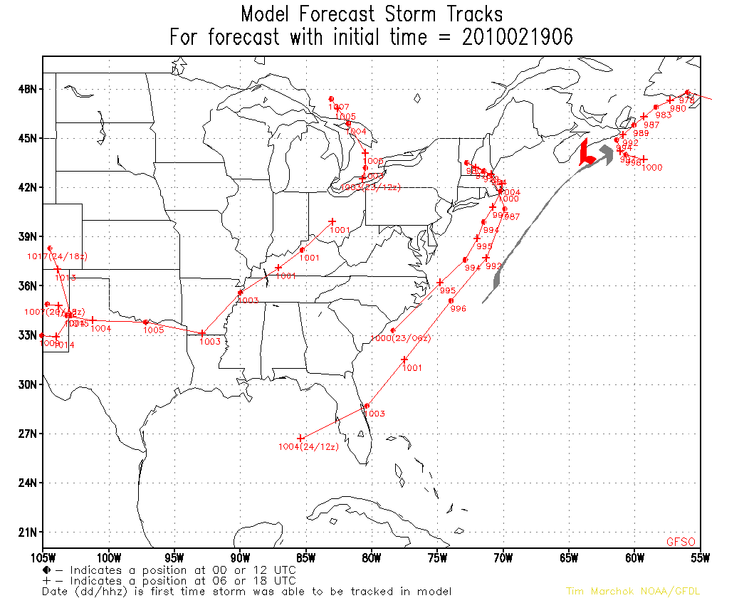
Très hâte de voir avec le GFS 12 utc de ce Vendredi si cette trajectoire demeureras. Pcq quand tu passes en moins de 24 Heures (position en Gris-Noir) à ce matin si à l'Ouest...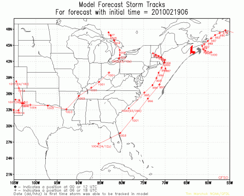
-
DISCUSSIONS PRÉVISIONS de 22 au 28 fév 2010
Mizar a répondu à un(e) topic de Trapper dans Discussions générales
Mais ce que je remarque depuis hier, et dites moi s'y je me trompe, mais après le passage de cet évènement, on dirait que le temps se replace beaucoup plus dans la normale des choses. Surtout au niveau de la circulation. Entretemps, je me dirige un peu comme la fin de semaine dernière, avec peut-être un autre 15-20 cm de neige à moitié mouillé le jour et qui s'accumule la nuit et ce jusqu'à Dimanche soir du à la tempête qui se trouve présentement sur Terre-Neuve et qui revient encore vers l'Ouest pour se retrouver près du Cap-Breton. J'aurai été plus honnête en disant entre 15 @ 20 mm d'équivalence d'eau. -
DISCUSSIONS PRÉVISIONS de 22 au 28 fév 2010
Mizar a répondu à un(e) topic de Trapper dans Discussions générales
Le GFS de 6h poursuit sur sa lancée avec plus de 40cm sur Québec On va prier et danser très fort Oui,danser fort et prier fort car il faut que cette tangente de trajectoire se stabilise pcq sa risque de sentir le chauffé tantôt... -
OBSERVATIONS DU 15 AU 22 FÉVRIER 2010
Mizar a répondu à un(e) topic de Pierre dans Discussions générales
Je suis surpris moi aussi, pas dans le sens de doute , mais dans le sens stupéfaction. Me semble que ça ne concorde pas avec ton appréciation de l'hiver. Qu'on t'entende encore critiquer! MH Michel, tu fait sûrement erreur sur la personne... Jamais au grand jamais que je ne me suis plaint qu'il n'avait pas de neige chez-moi, au contraire jai même déjà fait allusion que j'étais fort surpris que ce soit + l'Hiver dans le Sud du N-B qu'au Nord de chez-moi... C'est pas grave, je te pardonne. -
DISCUSSIONS PRÉVISIONS de 22 au 28 fév 2010
Mizar a répondu à un(e) topic de Trapper dans Discussions générales
N'empêche, si tout cela se concrétise d'ici la semaine prochaine, ça demeure assez fou de voir l'évolution de tout cela. Pas besoin de se rendre si loin, juste a voir pour les prochaines 36 @ 72 heures autour de Terre-Neuve et les Maritimes avec de constants systèmes revenant vers l'Ouest... c'est complètement maboule On a l'impression que notre circulation atmosphérique se fait maintenant de l'Est vers l'Ouest. -
OBSERVATIONS DU 15 AU 22 FÉVRIER 2010
Mizar a répondu à un(e) topic de Pierre dans Discussions générales
Comme je l'avait écrit ce matin et vu le temps doux qui se pointait pour la journée, comme d'habitude à cette periode de l'année, je me rend sur ma terre a bois pour refaire mon inventaire a bois de chauffage pour les années à venir... J'ai été un peu surpris par l'epaisseur de neige qu'il y avait tout le long pour me rendre à destination et après bien des avances recules(et bien des GES ), j'y suis enfin arrivé. J'ai en moyenne entre 80 et 100 cm au sol. Le problème, entre la neige de tomber ces derniers temps qui est pleine d'eau, à partir du milieu jusqu'au fond c'est de la croûte de neige assez solide et de la belle glace. Ça fait que quand je suis revenu avant l'heure de souper, j'était plus fatigué d'avoir eu a pelleter autour des arbres pour me rendre aux souches que d'avoir eu a couper le bois et a le corder. Ça fait que finalement, je me suis dit que j'y retournerais pas avant le mois d'Avril et que d'ici ce temps la, à moins que le ciel me tombe sur la tête, cette neige devrait fondre assez rapidement tellement qu'elle est pleine d'eau et surtout avec l'aide des chauds rayons de Soleil qui vont se faire de plus-en-plus réconfortant vers la mi-Mars.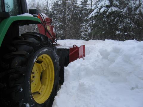
-
DISCUSSIONS PRÉVISIONS de 22 au 28 fév 2010
Mizar a répondu à un(e) topic de Trapper dans Discussions générales
Mais comme on peu encore le constater ce matin, c'est encore une question de phasage et le Ou,Quand et Coment s'applique encore une fois. Rarement vu le GFS "négocier" avec trois centres dépressionnaires. C'est plutôt le genre du NAM de le faire. Mais encore, c'est parfois les dérapages de certaines sorties du GFS car a comparer à son p'tit frère d'avant soit le 00 utc ...on est loin de ce scénario. Bonne Journée @ tous...moi j'men vais au bois pour la journée.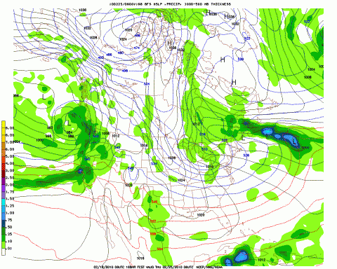
-
OBSERVATIONS DU 15 AU 22 FÉVRIER 2010
Mizar a répondu à un(e) topic de Pierre dans Discussions générales
Assez incroyable Alex les températures dans ton coin et c'est du jamais vu. C'est pratiquement comme cela depuis Décembre si je ne me trompe??? Je regardai Sept-Iles et à 22.00 le mercure est près de +5 Deg et en-plus avec des vents N-NE---j'en revient pas Moi et bien au final, ce ne fût pas le genre de tempête qui dépeigne mais comme on dit , je prend tout se qui passe. Elle a commencer vers les 05.30 am Mercredi Matin(avec beaucoup de retard) et est devenu + intense après le déjeuner avec le vent et la neige plus abondante. J'ai eu droit à près de 15 cm en tout et partout. Mais ce soir, tout de suite après la fin des précipitations, c'est la douceur qui s'installe avec un mercure qui grimpe tranquillement pas vite et je suis maintenant passe le cap du négatif avec un beau gros +0.4 Deg. Je suis sortis avec les chiens plutôt pour finir de pelleter ma galerie et il me vient aux narines une belle odeur saline provenant de la mer... signe qu'effectivement, la douceur sera présente pour un bout... pcq cela , ça ne trompe pas chez-moi. -
Un mois de Mars sous la neige...
Mizar a répondu à un(e) topic de castor028 dans Discussions générales
Y'a de bonnes chances Jean-Marc... -
DISCUSSIONS PRÉVISIONS de 22 au 28 fév 2010
Mizar a répondu à un(e) topic de Trapper dans Discussions générales
D'accord Pierre, rien n'est joué. Mais le GFS est-il vraiment constant ? Il y a deux jours, il ne voyait rien de ce système, ou presque. C'est les "Ups @ Downs" du GFS à moyen-terme Wawe et la je n'ose pas prononcer le long-terme, de toute manière donnons lui une chance ... c'est dur pour lui cet Hiver... -
Un mois de Mars sous la neige...
Mizar a répondu à un(e) topic de castor028 dans Discussions générales
Merci! @ tous pour les explications plus qu'instructivent les unes que les autres et que rajouter de plus et bien je pense que tout a été dit. Les raisons, peut-être qu'une bonne journée on les auras mais d'ici là, espérons que la nature et le temps sera bien faire les choses. Merci! encore -
OBSERVATIONS DU 15 AU 22 FÉVRIER 2010
Mizar a répondu à un(e) topic de Pierre dans Discussions générales
sans trop être redondant...
-
OBSERVATIONS DU 15 AU 22 FÉVRIER 2010
Mizar a répondu à un(e) topic de Pierre dans Discussions générales
suite...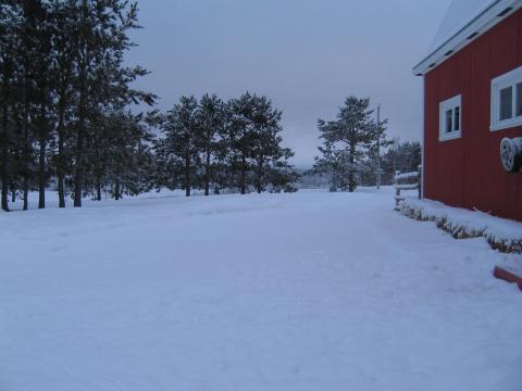
-
OBSERVATIONS DU 15 AU 22 FÉVRIER 2010
Mizar a répondu à un(e) topic de Pierre dans Discussions générales
Finalement cette neige a cesser vers l'aube Mardi Matin. Pres d'une quinzaine de cm d'accumuler durant cette période.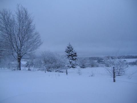
-
DISCUSSIONS PRÉVISIONS de 22 au 28 fév 2010
Mizar a répondu à un(e) topic de Trapper dans Discussions générales
Même si rien n'y parait,Gardez un coin de l'oeil sur le système pour le 24-25... -
Un mois de Mars sous la neige...
Mizar a répondu à un(e) topic de castor028 dans Discussions générales
Michel... J'aimerai bien que tu m'expliques une petite affaire. Pcq, souvent depuis quelques temps concernant cette situation météo, je te vois émettre souvent ce commentaire.., " La même question de l'été passé se pose encore: Comment l'air chaud peut-elle envahir l'arctique et s'y installer si longtemps sans se faire déloger? Bien malin celui qui pourra prévoir le moment du déblocage..." Tu ne crois pas que c'est El-Nino le responsable de ceci? El-Nino a pris naissance au cour de l'Été justement et ca coïncide avec ce pattern non? Comment ce fait-il, que présentement dans certaine parties de l'Europe c'est encore l'Hiver bien plus qu'à certains endroits au Canada? C'est justement prouver que pendant que l'on subit les effets de El-Nino dans notre partie du Globe... et bien c'est à ce-moment la que l'Europe connait des Hiver plus rigoureux. Je continu de croire dur comme fer, que quand ce El-Nino mourra de sa belle mort, tout les engrenages reprendreront leurs bonnes places. -
OBSERVATIONS DU 15 AU 22 FÉVRIER 2010
Mizar a répondu à un(e) topic de Pierre dans Discussions générales
Depuis plus au-moins 36 heures que j'ai droit à des précipitations dans mon coin. Ça débuter Dimanche matin sous forme de neige fondante @ bruine verglaçante vers l'heure du Midi à bruine tout court en après-midi pour redevenir de la neige vers le souper et a partir de là, c'est rester en neige et justement, j'ai commencé a accumuler à partir de ce temps et ce encore en ce-moment soit 22.50 pm Lundi Soir. De faible à très faible a modérer. Entre 10 et 12 cm de tomber. Mercure oscillant toujours entre 0 Degré @ -1 -2... J'aimerai bien voir ceci à Vancouver pendant les Jeux...ça nous plongerait plus dans l'ambiance. Cest un peu comme Noel sans neige. -
DISCUSSIONS PRÉVISIONS du 15 au 21 fév 2010
Mizar a répondu à un(e) topic de Trapper dans Discussions générales
Le suspence va se poursuivre dans mon cas jusqu'à demain.Il y a toujours un p'tit changement de passes en passes. Dans mon cas ce matin il y a quand même concensus entre le NAM et le GFS 06 utc avec des accumulations au alentour d'une trentaine de cms. Est-ce que ce Midi la tangente se poursuiveras??? Wait and see. Mais presque tout les modèles disponibles s'entendent sur une bordée. -
DISCUSSIONS PRÉVISIONS du 15 au 21 fév 2010
Mizar a répondu à un(e) topic de Trapper dans Discussions générales
Aucune place à peut-être un peu d'espoir ? Attend de voir le GFS 12 et le NAM de Dimanche Midi... ça prend une tangente plus vers le Sud. Excuser moi, je voulais dire vers le Nord donc vers le Sud du Québec...mais c'est le GFS 06 et le NAM 06...soyons prudent car c'est souvent une confirmation du 00 utc. Pcq c'est la zone de précipitation qui est + Nord et non pas le système en lui-même. Mais je vous la souhaite de tout Coeur...vu la St-Valentin. -
DISCUSSIONS PRÉVISIONS du 15 au 21 fév 2010
Mizar a répondu à un(e) topic de Trapper dans Discussions générales
Aucune place à peut-être un peu d'espoir ? Attend de voir le GFS 12 et le NAM de Dimanche Midi... ça prend une tangente plus vers le Sud. -
DISCUSSIONS PRÉVISIONS du 15 au 21 fév 2010
Mizar a répondu à un(e) topic de Trapper dans Discussions générales
J'avais hâte de revenir ce soir pour voir évoluer un peu tout cela. Entre le NAM et le GEM plus encourageant et le GFS qui passe de +en+ ce système a l'Ouest donc tranquillement plus au Nord de ma tête...verras-t-on. Faudrat être patient et voir le NAM et LE GEM du 00utc... Ça vient, j'gagne 5 cm par tranche de 24 heures... de 5 cm Hier soir @ 10 ce soir... donc il reste encore 3 jours : 3 x 5 = 15 + mon 10cm jusquà maintenant = 25 cm ma prévision quantitative est faite... Anyway, Bon Dimanche @ tous et surtout,,,surtout, la journée la plus importante de l'année. N'oubliez pas votre femme aujourd'hui pcq ça peut avoir comme la météo, un impact majeur sur le reste de la saison et même à plus long terme. 25 cm c'est pas mal la quantité que le GEM 12z te donnait.. reste à voir si ça va tenir. Oui Dave sauf qui y'avait du fondant à ma hauteur. Il est beaucoup plus chaud à ma latitude. -
DISCUSSIONS PRÉVISIONS du 15 au 21 fév 2010
Mizar a répondu à un(e) topic de Trapper dans Discussions générales
J'avais hâte de revenir ce soir pour voir évoluer un peu tout cela. Entre le NAM et le GEM plus encourageant et le GFS qui passe de +en+ ce système a l'Ouest donc tranquillement plus au Nord de ma tête...verras-t-on. Faudrat être patient et voir le NAM et LE GEM du 00utc... Ça vient, j'gagne 5 cm par tranche de 24 heures... de 5 cm Hier soir @ 10 ce soir... donc il reste encore 3 jours : 3 x 5 = 15 + mon 10cm jusquà maintenant = 25 cm ma prévision quantitative est faite... Anyway, Bon Dimanche @ tous et surtout,,,surtout, la journée la plus importante de l'année. N'oubliez pas votre femme aujourd'hui pcq ça peut avoir comme la météo, un impact majeur sur le reste de la saison et même à plus long terme. -
DISCUSSIONS PRÉVISIONS du 15 au 21 fév 2010
Mizar a répondu à un(e) topic de Trapper dans Discussions générales
J'avais hâte de revenir ce soir pour voir évoluer un peu tout cela. Entre le NAM et le GEM plus encourageant et le GFS qui passe de +en+ ce système a l'Ouest donc tranquillement plus au Nord de ma tête...verras-t-on. Faudrat être patient et voir le NAM et LE GEM du 00utc... -
DISCUSSIONS PRÉVISIONS du 15 au 21 fév 2010
Mizar a répondu à un(e) topic de Trapper dans Discussions générales
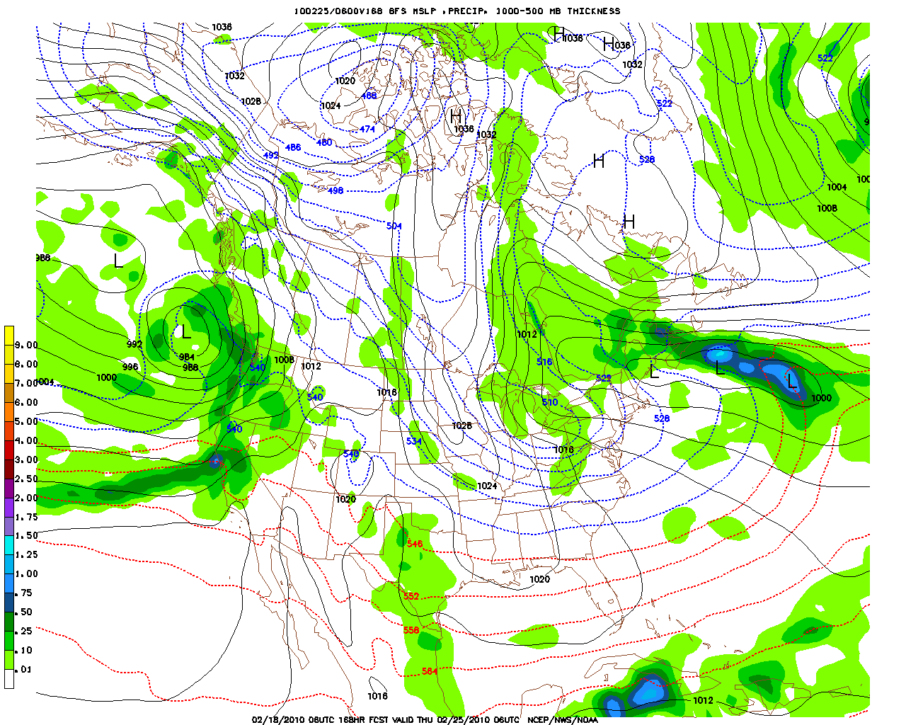
Bon et bien, cela éclaircie mes interogations jusqu'à maintenant et encore merci! Michel pour les explications. Ce qui me laissait encore perplexe ce matin, c'était de voir comment la plupart des modèles donnent un système quand même aussi puissant et pffff!!!! . Avec un centre dans les alentours de 100,101 et quelque peut-être. Laissons faire le temps. Michel, pourrait-tu s.v.p me donner le lien si possible pour voir justement les divers niveaux des fronts comme limage que tu as exposé sur ton illustration. Merci!