Pierre
-
Compteur de contenus
5 703 -
Inscription
-
Dernière visite
Type de contenu
Profils
Forums
Events
Gallery
Tout ce qui a été posté par Pierre
-
Attention ! Ca dépend par rapport à quoi tu compares. Si tu compares le GFS versus d'autre modèle globaux (GEM-GLB, ECMWF, UKMET, NOGAPS), il n'y a pas de raison que celui-ci fasse moin bien que d'autres à courte échéance (moin des 48hr). Par contre si tu compares aux modèles régionaux (NAM, GEM-Reg) c'est dernier devraient mieux performer (en moyenne) à courte échéance que le modèles globaux due à leur plus grande résolution. Sauf que le NAM est tellement poche (en moyenne) que même les modèles globaux font mieux que lui à courte échéance. Très juste !
-
AW modifie son tir aussi !
-
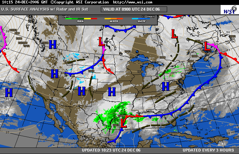
WOCN71 CWTO 241854 BULLETIN METEOROLOGIQUE SPECIAL EMIS PAR ENVIRONNEMENT CANADA REGION DE L'ONTARIO. 13H54 HNE LE DIMANCHE 24 DECEMBRE 2006. BULLETIN SPECIAL EMIS POUR.. VILLE DE TORONTO WINDSOR - ESSEX - CHATHAM-KENT SARNIA - LAMBTON ELGIN LONDON - MIDDLESEX SIMCOE - DELHI - NORFOLK DUNNVILLE - CALEDONIA - HALDIMAND OXFORD - BRANT NIAGARA VILLE DE HAMILTON HALTON - PEEL YORK - DURHAM HURON - PERTH WATERLOO - WELLINGTON DUFFERIN - INNISFIL GREY - BRUCE BARRIE - ORILLIA - MIDLAND BELLEVILLE - QUINTE - NORTHUMBERLAND KINGSTON - PRINCE EDWARD PETERBOROUGH - KAWARTHA LAKES STIRLING - TWEED - FRONTENAC SUD BANCROFT - PARC BON ECHO BROCKVILLE - LEEDS ET GRENVILLE ville d'Ottawa GATINEAU PRESCOTT ET RUSSELL CORNWALL - MORRISBURG SMITHS FALLS - LANARK - SHARBOT LAKE PARRY SOUND - MUSKOKA - HUNTSVILLE HALIBURTON Renfrew - Pembroke - Barry's Bay ALGONQUIN Burk's Falls - Bayfield Inlet. ..NEIGE POUR LE LENDEMAIN DE NOEL..COMMENCANT LE SOIR DE NOEL DANS CERTAINES LOCALITES.. UNE DEPRESSION EN FORMATION SUR LE GOLFE DU MEXIQUE DEVRAIT SE DIRIGER JUSTE AU SUD DES LACS INFERIEURS LE LENDEMAIN DE NOEL. LA PLUIE BIEN A L'AVANT DE LA DEPRESSION ATTEINDRA L'EXTREME SUD-OUEST DE L'ONTARIO LE MATIN DE NOEL PUIS ELLE SE REPANDRA RAPIDEMENT VERS LE NORD-EST SUR LE RESTE DU SUD DE L'ONTARIO AU COURS DE L'APRES-MIDI ET DE LA SOIREE. SUR LES SECTEURS NORD LA PLUIE SE CHANGERA RAPIDEMENT EN NEIGE..ALORS QUE LES SECTEURS PRES DES LACS INFEREIEURS NE VERRONT PAS DE TRANSITION ENTRE LA PLUIE ET LA NEIGE AVANT LE MATIN LE LENDEMAIN DE NOEL. LA NEIGE CESSERA ENSUITE PROGRESSIVEMENT DU SUD-OUEST AU NORD-EST AU COURS DE LA JOURNEE. DES INDICATIONS TRES PRELIMINAIRES MONTRENT QUE CETTE ACCUMULATION DE NEIGE DE 10 A 20 CENTIMETRES POURRAIT SURVENIR DANS UN COULOIR ALLANT DE KITCHENER AUX REGIONS AU NORD DE TORONTO..PUIS VERS LE NORD SUR LA REGION DE VILLEGIATURE ET SUR la vallee de l'Outaouais. ON PREVOIT UNE ACCUMULATION MOINDRE AILLEURS AVEC ENVIRON 5 CENTIMETRES POSSIBLES A TORONTO. TOUTEFOIS LA DEPRESSION NE FAIT QUE COMMENCER A SE FORMER ET UN CHANGEMENT MINIME DANS SA TRAJECTOIRE PREVUE POURRAIT MODIFIER LES REGIONS DU VISEES PAR L'AVERTISSEMENT DE NEIGE ABONDANTE. ENVIRONNEMENT CANADA CONTINUERA DE SURVEILLER CETTE SITUATION DE PRES. SURVEILLEZ LES PROCHAINS BULLETINS. POUR DE PLUS AMPLES RENSEIGNEMENTS VEUILLEZ CONSULTER LES DERNIERES PREVISIONS PUBLIQUES. LES PROCHAINES PREVISIONS PUBLIQUES SERONT EMISES VERS 15H30. FIN/GR
-
Vidéo dimanche midi de Henry Margusity de AW... Désolé pour ceux qui ne sont pas abonnés au service professionnel de AW...Merci Bouli ! Il explique clairement la situation pour mardi et il mentionne aussi que les modèles sous-estime l'intensité du deuxième système ...il met aussi la zone de neige forte en plein sur le sud du Québec....ce qui est conforme avec leur carte postée plus haut ....
-
Le GFS 12z donne une grosse tempête de verglas et ou grésil pour MTL.... On sait ce que ça vaut à ce moment-ci ....
-
L'image ci haut avait déjà été mise plus haut sur une autre page de cette discussion.... Ceci dit, le Nouveau GEMGB 12Z vient de sortir et il maintient les principaux éléments du 00Z ...il maintient de la neige et là aussi du 10 à 20 cm selon les secteurs.
-
Le nouveau NOGAPS 12Z donne aussi 10 à 20 cm pour MTL.... Bien que les modèles donnent des trajectoire un peu plus à l'est (à part le GEMREG de EC) il n'en demeure pas moins qu'en moyenne jusqu'à maintenant on aurait droit à 10 à 20 cm sur sur le sud du Québec ...en autant que la température au sol ne soit pas trop haute .... Lisez l'explication de ROMIE plus haut c'est rempli de bon sens
-
C'est toujours à suivre ..... Henry Margusity's Severe Weather Outlook Email Henry | Check Out Henry's Henry Margusity's Column: December 24, 2006 This discussion is updated only the days that Henry is available, usually Monday-Friday. Check the date above and come back often! Sunday Morning - Category 3 Storm A DAY LATE, BUT AT LEAST IT'S SNOWING.... Here's the game plan for today. I will post this morning and then cut a video and another post to be online around 1 p.m. this afternoon. The next may wait until Christmas morning, unless I can get a quick update out this evening while rounding-up excited kids into bed...I should be able to get a quick update out Christmas night, then Tuesday morning, I start storm updates on where the heavy snow is falling. After that, I rest for a day or two before I start with the 30th storm.... Now that we have forecasted the storm coming, I want to have you watch the evolution of the storm and how this all comes together to produce a storm. Below is the water vapor imagery from the AccuWeather.com site. What that is showing you is the water vapor in the atmosphere and it's a good tool to use to find the various weather features. The green areas are the very moist areas, while the yellows are the dry areas. What you see this morning is a lot of moisture gathering across Texas and the western Gulf of Mexico where the storm is taking shape. Notice that already you have a nice comma shape look to the structure of the storm which is an indication of the developing storm. Now, notice over the system coming across Wyoming and the northern Plains. That's the northern branch system that will eventually phase with the system over Texas to produce the storm in the East. Notice how already moisture is being drawn up ahead of that northern branch system across the Mississippi Valley. The models overnight have been playing the typical day before the storm games. The NAM model has gone west with the storm while the GFS has gone east with the storm, and the two will play more games during the 12z runs, but I am hopeful that they finally come to a consensus on the track of the storm. I liked last nights GFS 00z run and the track of the storm with the main low running up through Virginia, then strengthening heading into New England, and a reflection of low pressure for a time back in the Ohio Valley. What has to happen with the storm, the energy you see coming through Wyoming this morning has to dive into the Tennessee Valley, forcing the energy now over Texas, up and out to the northeast. As the energy digs in late tomorrow and tomorrow night, we will see rapid deepening of the storm, and rain changing to snow in places like Tennessee, and maybe even as far south as Mississippi and Alabama. The big snowfall starts across eastern Tennessee and eastern Kentucky, then heads north-northeast through West Virginia, western and central Pennsylvania, western and central New York, Vermont, New Hampshire and Maine, which changes over to snow all the way into the I-95 corridor. Now, I will say I-95 corridor folks, don't get excited. It's not your storm, it's only a change over to some wet snow on the end. New England, however, could see some accumulations of snow. Now, I opted to go with a category 3 storm on the Winter Storm Chart only because I think the top end of the storm has a foot somewhere from northern Pennsylvania into New York, Vermont and New Hampshire. Keep in mind, this is going to be a wet snow, not a snow at 25 degrees, but a snow at 32-34 degrees in most areas. I will say, the error that I might make is having the snow area too far East. There is still the camp out there for a storm track west of the Appalachians, and that is still possible. I know I am sticking my neck out on the snow area, but that's me and this is what I think will happen. Another aspect of the storm will be the severe weather across the eastern Carolina's into Florida. I think there will be quite a small squall line with the storm that will produce wind damage and hail as the primary threat, let alone, heavy rain across the Southeast into the mid-Atlantic. In addition, on the front end of the storm, ice and snow could be a problem from the West Virginia valleys into central Pennsylvania tomorrow and central New York where enough chilly, dry air is in place for some ice and snow at the start of the rain.
-
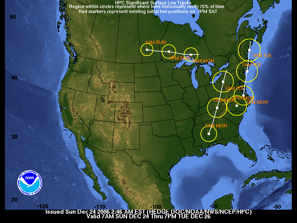
Et sa trajectoire prévue...On note la formation d'un second système .....

-
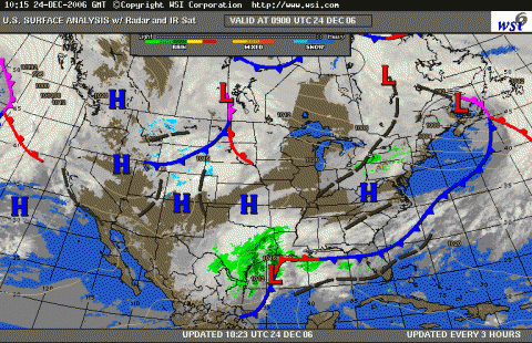
Naissance de la tempête ce matin.....Elle est dans le Golfe du Mexique....
-
Le GEMGB 00Z nous donne bel et bien une tempête de neige avec possiblement 15 à 25 cm pour MTL.... peu de changements sur les derniers runs...
-
Le modèle Européen ECMWF (le plus fiable) pousse également la tempête vers l'est nous mettant plus dans l'air froid comme le GFS 0Z, mais il s'ensuivra moins de précipitations.... On aura une autre idée avec le GEMGB dans quelques minutes....
-
Voici la dernière discussion de Henry sur Accuweather.... Henry Margusity's Meteorological Madness! Saturday Evening Storm Update - Category 3 Storm Sunday, December 24, 2006 Sorry folks for the late post today. I've been out and about doing last minute x-mas shopping.... Those of you who were able to watch the videos today, I don't really have a whole lot to add tonight. So here's my points on the storm...Yes, I am starting to stick my neck out on the first look at accumulations and weather conditions. 1. The models seem to have come to a consensus of a storm going up west of the Appalachians, then a secondary low develop near eastern Virginia x-mas night that's explodes northeast. 2. I am going ith a cateory 3 storm with amounts up to a foot in places. 3. The snow area will go from Tennessee through Kentucky into Ohio, Ontario, with a secondary mas of snow from western and central New York into Qubec, northern Vermont, northern New Hampshire and Maine. 4. Lesser amounts of snow back into Missouri, Illinois, east into West Virginia, central PA, eastern New York and New England. 5. Change from rain to wet snow all the way to the I-95 corridor from Philly on north. Best chance of accumulating snow will be from New York city into central Mass. 6. The places that get the hardest by heavy snow will be eastern Kentucky, West Virginia Mountains, NW PA, western and central New York into Quebec. 7. The storm will be back end loaded, meaning the rain will change over ot snow on the tail end of the storm in most places. 8. Near blizzard conditions are possible from western and central PA north into western and central New York and Quebec. Winds may gust up and over 50 mph with snow. Folks, this is going to be wild storm with high winds, heavy snows, heavy rains and flooding on the front end, and severe weather possible across the eastern Carolina's and southeast Virginia, while a massive squall line attacks Florida and southeast Georgia. That's all I have for the night. My next update will be tomorrow morning. I will be doing a video update, but that will not be ready until around lunch tomorrow.
-
Voici la dernière discussion du NWS Burlington.... Long term /Tuesday through Saturday/... 12z Tuesday through 12z Wednesday...impacts from major east Continental U.S. Cyclogenesis continue at start of the extended period...with continued forecast low track uncertainty. One question is extent to which a coastal low may try to develop east of primary system tracking north-northeastward through the central Appalachians...to near central PA at 12z Tuesday. The 12z NAM at 72hrs shows a deepening low closer to the coast Tuesday morning /sern PA area/...with a track to near kleb /965mb!/ At 00z Wednesday. Meanwhile...the GFS only hints at coastal development...with a eastward extending trough in the surface pressure field to the Cape Cod area at 12z Tuesday. The primary low in the 12z GFS tracks to near kuca at 18z Tuesday...and then across the forecast area by Tuesday evening. The 00z European model (ecmwf) favored a track east of the forecast area...with an impressive 977mb surface low near Worcester Massachusetts at 00z Wednesday. However...the new 12z European model (ecmwf) suggests a track further west...allowing more warm air /supporting rain/ into the forecast area. The wide range of solutions in the nwp guidance stems from the upstream phasing that occurs between a northern stream 500 mb trough digging into the southeastern Continental U.S....and how it interacts with pre-existing upper vorticity over the Gulf of Mexico. Timing is of the essence between both systems...and the quality of the model initialization of both systems. This degree of uncertainty in the subsequent surface low track is not that unusual in these situations. On Tuesday...believe we/ll be dealing with a rain/snow mix. Thermal stratification likely to stay slightly colder in northern New York...and period of rain Tuesday may be a few hours less than in Vermont. By Tuesday afternoon...strong dynamic and latent cooling with the occluding system should allow the mixed rain and snow to become all snow...heavy for a few hours...before tapering off Tuesday evening. Temperatures Tuesday should be warmest during the morning hours /mid to upper 30s/...with a slow downward trend in the afternoon due to dynamically/diabatic influences aloft with strong upward vertical velocity and melting condensate. Snowfall amts will depend on how much rain mixes in...and will likely vary from west to east and with elevation across the forecast area. The most snow is likely to occur in the Adirondack Mountains as it appears now. Either way...travel will be adversely impacted on Tuesday across the entire forecast area...and forecasts should be closely monitored...with potential for at least several hours of heavy...1-2"/hr snow...and strong winds given depth of surface system.
-
Il est un peu tôt pour rejeter la suggestion du NAM ....Par contre on sait qu'il est moins fiable que l'ancien ETA....Nous verrons bien.
-
Le NAM 12z montre de bonnes quantités de précipitations pour MTL.... 30 à 35 mm d'équivalent d'eau pour être précis avec encore une fois un risque de mélange au début et au moins 10 cm de neige pour Montréal .... À noter les vents du nord-est de 50 à 80 km/h ....Une pression près de 97,5mb...Gageons que ça va brasser si ça reste comme ça !
-
Le GEMGB 00Z donne maintenant de bonnes accumulations possiblement plus de 15 - 20 cm mardi !!!
-
Un mélange au début prévu par le GFS...Source GFS 00Z ACCUPROF. Un 15 à 20 cm pour MTL.... SFC 850 SFC SFC 700 3/6 500 1000 TMP TMP PRS RHU RHU HR HGT 500 © © (MB) (PCT) (PCT) (IN) (DM) THK SAT 00Z 23-DEC -1.0 2.7 1023 86 100 564 546 SAT 06Z 23-DEC 1.2 2.6 1016 95 100 0.27 560 547 SAT 12Z 23-DEC 1.5 4.0 1011 99 92 0.23 558 549 SAT 18Z 23-DEC 2.4 2.3 1003 98 92 0.21 549 546 SUN 00Z 24-DEC 2.1 -4.2 1003 96 77 0.07 538 536 SUN 06Z 24-DEC 1.7 -3.8 1001 93 68 0.02 537 536 SUN 12Z 24-DEC 1.3 -5.8 1003 92 95 0.04 533 531 SUN 18Z 24-DEC 1.3 -5.3 1006 88 49 0.05 531 526 MON 00Z 25-DEC -0.4 -6.4 1012 90 30 0.00 540 530 MON 06Z 25-DEC -0.9 -7.0 1016 89 21 0.01 547 534 MON 12Z 25-DEC -1.5 -5.6 1019 90 32 0.00 552 536 MON 18Z 25-DEC 1.4 -2.0 1018 79 12 0.00 554 539 TUE 00Z 26-DEC -1.5 -2.8 1016 90 14 0.00 553 540 TUE 06Z 26-DEC -1.3 -4.0 1011 92 98 0.03 549 539 TUE 12Z 26-DEC -1.3 -2.1 1003 94 93 0.07 546 544 TUE 18Z 26-DEC -0.8 -4.3 987 96 97 0.14 532 544 WED 00Z 27-DEC -1.1 -4.6 978 98 98 0.55 514 532 WED 06Z 27-DEC -4.6 -9.4 982 96 97 0.12 513 528 WED 12Z 27-DEC -8.3 -13.9 995 96 90 0.03 519 524 WED 18Z 27-DEC -8.0 -14.8 1002 96 98 0.02 519 517 THU 00Z 28-DEC -14.8 1010 40 0.03 526 518
-
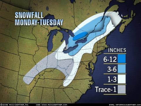
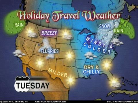
Pour mardi....
-
J'ouvre un nouveau sujet la dessus et je donne le crédit à Patrick (Patito) qui en parle depuis un certain temps déjà....et à DANN17 qui en parrlé avant hier ... ... Alors, On a actuellement les modèles Européens (UKMET et ECMWF) et le modèle GFS qui dévelloppent une tempête côtière les 25 et 26 décembre et qui la font passer suffisamment près du Québec pour qu'on ait des quantité significatives de précipitations (LE GFS descend la pression à 98 mb entre autre sur YUL ) et suffisamment loin pour que les précipitations soient sous forme solide (grésil et neige) ... D'autres parts, LE GEMGB et le NOGAPS développent aussi le système mais le maintiennent loin sur la côte est....avec moins de précipitations... Pour le moment je suis dans le camp des Américains et surtout des Européens (ECMWF) qui montrent constamment le système avec une trajectoire assez constante....sur nous. À suivre !
-
On voit déjà que la météo jouera sur les extrêmes ....De plus en plus de records vont tomber , mais de façon plus concrète, les inondations qui se produisaient au printemps au Québec se retrouveront à n'importe quel moment de l'année....Il n'est plus rare de voir des précipitations de 80 ou 100 mm en moins de 24 heures... Mais je crois bien , comme l'a dit Skipo actuellement c'est l'érosion sur la côte nord et la fonte du pergélisol qui posent le problème le plus criant....à ce jour.
-
Et pourquoi je me sens concerné ...? C'est parce que dans le domaine hydrométéorologique ou j'évolue actuellement (inondations / embâcles) je vois des choses inhabituelles qui vont finir par affecter plein de gens , d'organismes, d'activités , sports et loisirs.... Je suis Géophysicien de formation et dans le cadre de nos cours universitaires nous avons touché a pas mal toutes les facettes du climat depuis des millions d'années. Il existe plusieurs moyens pour déterminer l'évolution des températures depuis ces millions d'années. La paléoclimatologie nous a fait voir que la terre subit depuis des millions et des millions d'années des cycles de refroidissement et de réchauffement qui conduisent à des glaciations et des périodes plus chaudes. Il y a près de 20000 ans par exemple, il y avait de 3 à 4 km de glace sur nos têtes au Québec. C'était la dernière ère glaciaire. Actuellement selon les cycles glaciation / réchauffement on devrait aller vers une glaciation (dans des milliers d'années !) ....Et surprise ça se réchauffe à la place....Il est aussi vrai que depuis 50 ans au moins, la concentration de gaz Méthane et Carbonique augmente en flèche dans l'atmosphère....Parallèlement la hausse des températures la plus tangible se mesure dans les 100 dernières années et plus particulièrement depuis 50 ans. Sans rejeter d'autres hypothèses qui peuvent aussi avoir un certain rôle a jouer, je crois que nous avons suffisamment de preuve pour pointer du doigt les gaz à effet de serre ...pour ce réchauffement.....peu importe leur source (naturelle ou humaine)
-
Si j'ai démarré ce sujet c'est parce que je crois qu'il y plein de choses intéressantes à dire la dessus.... Je vous invites donc à rester respectueux de toutes les opinions qui seront émises ici....
-
Les ingredients reunis pour une bombe
Pierre a répondu à un(e) topic de Patito dans Discussions générales
MAIS QUI EST DONC CE BRETT ANDERSON...... Brett Anderson Brett Anderson was born October 22, 1966 in Providence, RI. Having experienced all sorts of New England weather from blizzards to hurricanes, he became very interested in the weather at about age 8. He also built his own weather station soon after and based a number of his school projects on the weather and specific storms. Brett graduated from Rutgers University in 1989 with a BS degree in atmospheric science. He quickly became employed at Accuweather later in the summer of that same year. At Accuweather Brett is an on-air radio forecaster serving a number stations across the eastern half of the country. He is also occasionally involved with the production of feature graphics and weather headlines seen on Accuweather.com. Brett has been married to his wife Cheryl since 1991, who he met in college. They are the proud parents of Scott born in 1993 and Kaitlin born in 1996. In his spare time Brett enjoys playing ice hockey and basketball. Brett is a fan of the Oakland A's and the Montreal Canadiens.
-
Dans le Bog de Bret Anderson...d'AW White Christmas Hopes Fading for Some Wednesday, December 20, 2006 Updated White Christmas chances. My original forecast percentages from Monday will be in regular type if I feel that they did not need to be changed. Any updated percentages will be in bold.. You will note the marked decrease in the percentages for eastern Ontario and southern Quebec. When I made the forecast Monday I was banking on the storm moving up Christmas day. Now, it looks like the storm will wait until late Christmas night, and that really does not count for a white Christmas. Site................................................% chance of a White Christmas (morning and day) Whitehorse, Yukon...........100% Yellowknife, NT...............100% Prince George, BC...........100% Kamloops, BC..............60% Kelowna, BC............40% Vancouver, BC........5% Victoria, BC..........0% Grand Prairie, AB...........100% Fort McMurray, AB........100% Edmonton, AB...........90% Calgary, AB..........down to 10% Lethbridge, AB.........down to 5% Regina, Sask........70% Saskatoon, Sask......up to 70% Winnipeg, Man..........up to 60% Thunder Bay, Ont.......up to 50% Sault Ste. Marie, Ont..........down to 50% Sudbury, Ont.........down to 40% North Bay, Ont........down to 50% Windsor, Ont.......down to 10% London, Ont........down to 30% Toronto/Hamilton, Ont........down to 20%, but it may snow later Christmas night Barrie, Ont.........50% Kingston, Ont........down to 20%, but it may snow late Christmas night Ottawa, Ont......down to 40%, but it may snow late Christmas night and Tuesday Montreal, Que...........down to 30%, but it may snow very late Christmas night. Sherbrooke, Que.......down to 40%, but it may snow late Christmas night or Tue. Quebec City, Que..........down to 50% Rimouski, Que.........down to 60% Edmundston, NB........down to 40% Fredericton, NB........down to 20% Saint John, NB........down to 20% Moncton, NB..........down to 30% Halifax, NS.........30% Sydney, NS........30% Charlottetown, PEI.......down to 30% St. John's, NF..............down to 20% Gander, NF.........down to 40% Deer Lake, NF........60%