iceberg
-
Compteur de contenus
1 349 -
Inscription
-
Dernière visite
-
Jours gagnés
47
Type de contenu
Profils
Forums
Events
Gallery
Tout ce qui a été posté par iceberg
-
Observations du 18 au 24 avril 2011
iceberg a répondu à un(e) topic de Trapper dans Discussions générales
Rafale à 76.0 km/h à 12 h 30! St. leonard -
Un autre tremblement de terre au Japon de 6.5 un autre Tsunami ???
-
Observations du 31 jan au 6 fév 2011
iceberg a répondu à un(e) topic de Pierre dans Discussions générales
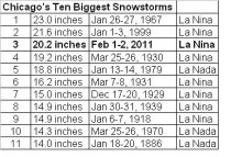
Tempête de neige à CHICAGO s'établit à NO.3
-
Observations du 31 jan au 6 fév 2011
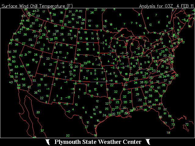
iceberg a répondu à un(e) topic de Pierre dans Discussions générales
http://forecast.weather.gov/MapClick.php?l...n&FcstType=text Même à Brownsville ils ne peuvent pas échapper au froid de l'Arctique.
-
J'ai fait une petite prière.
-
POUR MONTREAL....20 A 30 CM...MERCI....
-
Observations du 17 au 23 janvier 11
iceberg a répondu à un(e) topic de Pierre dans Discussions générales
MONTREAL -EST... OBSERVATIONS... http://pages.videotron.com/slmeteo/ -
Records de chaleur en décembre dans l'Arctique
iceberg a répondu à un(e) topic de Bouboule de neige dans Discussions générales
Un nouveau record mensuel pour Pangnirtung..Nunavut pour un mois de Janvier. maximum de +7c Mais je crois toujours que sa part d'un cycle climatique. -
Observations du 27 déc au 2 janvier 2011
iceberg a répondu à un(e) topic de dave20 dans Discussions générales
MIAMI BEACH ALASKA.....
-
Observations du 27 déc au 2 janvier 2011
iceberg a répondu à un(e) topic de dave20 dans Discussions générales
RECORD EVENT REPORT NATIONAL WEATHER SERVICE MIAMI, FL 200 PM EST TUE DEC 28 2010 ...RECORD LOW TEMPERATURE BROKEN AT MIAMI BEACH TODAY... A RECORD LOW TEMPERATURE OF 40 DEGREES WAS SET AT MIAMI BEACH TODAY. THIS BREAKS THE OLD RECORD OF 44 SET IN 1980. RECORD TEMP BASSE CONTINUE EN FLORIDE. -
Observations du 20 au 26 décembre 2010
iceberg a répondu à un(e) topic de Pierre dans Discussions générales
averse de neige -11c a St.Leonard. -
VOILA... http://www.climat-quebec.qc.ca/home.php?id...n=&from=m&lg=en
-
Incroyable tempête de grêle. Vous devez voir cette incroyable tempête de grêle.
-
Observations du 12 au 19 octobre
iceberg a répondu à un(e) topic de Pierre dans Discussions générales
Grains de neige légère ont été signalés à St. leonard aujourd'hui à 12h30pm. -
Observations du 27 au 3 octobre
iceberg a répondu à un(e) topic de Pierre dans Discussions générales
Je viens tout juste d'atteindre le 70 mm. -
Observations du 27 au 3 octobre
iceberg a répondu à un(e) topic de Pierre dans Discussions générales
Je viens tout juste d'atteindre le 62 mm. -
Observations du 2 au 6 juin 2010
iceberg a répondu à un(e) topic de Pierre dans Discussions générales
http://www.erh.noaa.gov/er/btv/ Veille de tornade en vigueur. -
OBSERVATIONS DU 24 AU 30 MAI 2010
iceberg a répondu à un(e) topic de Pierre dans Discussions générales
OBSERVATION POUR MONTREAL -EST http://pages.videotron.com/slmeteo/index.htm -
Observations du 4 au 9 mai 2010
iceberg a répondu à un(e) topic de Pierre dans Discussions générales
NEIGE DANS LE SUD DE LA FRANCE. http://www.meteociel.com/temps-reel/obs_vi...2010&envoyer=OK -
Un orage fort frappe St. LEONARD ce matin. La grêle a été également observé. De 8am à 9am un total de 22,2 mm de pluie est tombé et le taux de pluie était à 93,6 mm / h. Pendant la nuit un autre 20,4 mm est tombé pour un total de 42.2MM de pluie pour aujourd'hui. Cette information est de ma station météo. Voici le lien pour ma station.... http://pages.videotron.com/slmeteo/index.htm Débit de pluie le plus élevé 93,6 mm / h à 8h25 le 07 avril 2010 Plus fortes précipitations horaires 22,2 mm à 9:03 am le 07 avril 2010 Plus fortes précipitations quotidiennes 42,6 mm le 07 avril 2010
-
Observations du 1er avril au 4 avril
iceberg a répondu à un(e) topic de Pierre dans Discussions générales
La première date pour un temp 30c était le 20 avril 1941 pour Mcgill Montréal. -
Observations du 1er avril au 4 avril
iceberg a répondu à un(e) topic de Pierre dans Discussions générales
OBSERVATION POUR MONTREAL -EST.. http://pages.videotron.com/slmeteo/today.htm -
DISCUSSIONS PRÉVISIONS du 22 au 28 mars 2010
iceberg a répondu à un(e) topic de Trapper dans Discussions générales
Jean Marc pour le 28 mars, je prédis que le soleil se lèvera et il va ce coucher aussi. Nuageux avec percées de soleil pour le 28 mars. -
OBSERVATIONS 22-23-24 MARS 2010
iceberg a répondu à un(e) topic de Pierre dans Discussions générales
Un bon test pour votre station meteo aujourd'hui. Allez visiter le Nord de la péninsule d'Avalon. http://www.meteo.gc.ca/warnings/report_f.html?nl28 http://www.meteo.gc.ca/city/pages/nl-18_metric_f.html -
S'il vous plaît gardez votre calme Février 1981 a été un mois très chaud avec température beaucoup plus élevée alors que nous avons vu cette semaine. Il y avait d'autres années dans les années 1840 où temp étaient chauds et avec peu de neige pendant la saison d'hiver. Je parie que l'hiver prochain, nous verrons une saison beaucoup plus froid l'hiver et tout le monde sera heureux.