iceberg
-
Compteur de contenus
1 349 -
Inscription
-
Dernière visite
-
Jours gagnés
47
Type de contenu
Profils
Forums
Events
Gallery
Tout ce qui a été posté par iceberg
-
Observations du 15 au 21 mars 2010
iceberg a répondu à un(e) topic de Pierre dans Discussions générales
P-E-T a 12.8C à 16h00, comment tu fais pour avoir 16.4C ? Pourquoi pas! temps ne vont pas être les mêmes partout! -
Observations du 15 au 21 mars 2010
iceberg a répondu à un(e) topic de Pierre dans Discussions générales
MONTREAL-EST TEMP MAX DE 16.4C A 15:24 WOW! -
Observations du 8 au 14 mars 2010
iceberg a répondu à un(e) topic de Pierre dans Discussions générales
OBSERVATION-MONTREAL- EST http://pages.videotron.com/slmeteo/index.htm -
Cet événement d'hiver chaud que le Canada a connu cette saison d'hiver a été causé par l'événement El Nino et les hauts de blocage dans le nord du Canada. Dans les années 1920 à 1940 l'Arctique était beaucoup plus chaud. Les hivers à Montréal ont été plus doux et pas beaucoup de neige dans les années 1920. Tout cela est un cycle. Voici le lien sur ce sujet...... http://cei.org/pdf/ait/chVIII.pdf
-
Observations du 8 au 14 mars 2010
iceberg a répondu à un(e) topic de Pierre dans Discussions générales
http://buzz.yahoo.com/buzzlog/93460?fp=1 TORNADO ACTION !!!!! -
Observations du 8 au 14 mars 2010
iceberg a répondu à un(e) topic de Pierre dans Discussions générales
Pour ma station pour Montreal -Est Mois de mars Moyenne Min....-2.2c Moyenne Max....6.8c Moyenne Min+max...2.3c -
Devinez la date du premier orage
iceberg a répondu à un(e) topic de stefano dans Discussions générales
POUR MONTREAL....11 MAI POUR LA BELLE PROVINCE....1 MAI -
Observations du 8 au 14 mars 2010
iceberg a répondu à un(e) topic de Pierre dans Discussions générales
Max de 10.4C a 15:35pm MONTREAL -EST. -
La terre tremble en Turquie
iceberg a répondu à un(e) topic de olivier_200 dans Discussions générales
Experts LONDRES - affirment qu'il n'ya rien d'inhabituel dans la dernière vague de tremblements de terre en Haïti, au Chili et maintenant, la Turquie, mais leurs ravages illustre de quelle manière une construction le long des lignes de faille du monde peut conduire à des pertes massives. Les sismologues dire que même si un séisme puissant peut théoriquement augmenter le risque pour d'autres, ailleurs, la récente série de tremblements de terre est probablement juste une coïncidence. Bob Holdsworth, un expert en tectonique à l'Université de Durham, a déclaré lundi que "Je peux certainement vous dire que le monde ne vient pas à sa fin." Bernard Doft, le sismologue à l'Institut Royal Météorologique Pays-Bas, dit qu'il n'y a pas de lien direct entre les tremblements de terre meurtrier qui a frappé Haïti, le Chili et la Turquie. «Ces événements sont trop éloignés pour être d'une influence directe à l'autre, dit-il. Bien que le tremblement de terre survenu haïtienne long d'une faille qui avait vu aucun événement majeur pour les 250 ans, le Chili et la Turquie sont sujettes aux tremblements de terre dévastateurs. «C'est par hasard que c'est arrivé à peu près au même moment, dit-il. Plus de la moitié des villes avec au moins 1 million de personnes sont sur les frontières de plaques actives, qui sont ceux où les tremblements ont tendance à se produire, a déclaré l'Université du Colorado géologue Roger Bilham. Malheureusement, malgré les tremblements de terre passés, les gens continuent à mettre en place les nouveaux bâtiments mal construits, a déclaré Bilham, qui vient de rentrer d'Haïti et observé ces mauvaises pratiques. Séisme de lundi en Turquie, d'une magnitude 6,0. En moyenne, il ya 134 tremblements de terre d'une année qui ont une magnitude entre 6.0 et 6.9, selon le US Geological Survey. Cette année a pris un départ rapide avec 40 à ce jour - plus que dans la plupart des années pour cette période de temps. Mais c'est parce que le tremblement de terre 8,8 au Chili ont généré un grand nombre de fortes répliques, et tant d'survenant très tôt dans l'année fausse l'image, a déclaré Earle. "Les années qui ont tremblements de grandes chances d'être plus élevés dans la sismicité globale", a dit M. Earle. Le tremblement de terre du Chili est la sixième plus forte depuis 1900. AAP JE CROIS QUE TROP C'EST TROP MAINTENANT AVEC CES NOUVEAUX SUJETS SUR LES TREMBLEMENTS DE TERRE ET MAINTENANT LA FIN DU MONDE. CECI EST UN FORUM DE MÉTÉO.PAS UN FORUM SUR DOOMSDAY. -
Nous pouvons espérer un temp normale ce printemps et aussi pour la pluie. Temp dans l'Arctique étaient dessus de la normale cet hiver.Aussi Le phénomène El Nino va progressivement disparaître ce printemps.La neige sur le sol est sous la normale dans le sud du Canada.
-
OBSERVATIONS DU 1ER AU 7 MARS 2010
iceberg a répondu à un(e) topic de Pierre dans Discussions générales
Observation.....Montreal-Est http://pages.videotron.com/slmeteo/index.htm -
tremblement de terre majeur à Los Angeles
iceberg a répondu à un(e) topic de castor028 dans Discussions générales
L'El Niño dans l'océan Pacifique. Les eaux plus chaudes rongent la nourriture de leurs SOURCES.Ils recherchent des eaux plus froides. ils nager vers la côte de la Californie et la Colombie-Britannique. http://heppelllab.blogspot.com -
Voici le lien pour plus de detail... http://earthquake.usgs.gov/earthquakes/rec.../us2010tgbh.php http://earthquake.usgs.gov/earthquakes/rec...gbh.php#summary
-
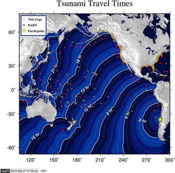
SANTIAGO, Chili - Un massif séisme de magnitude 8,8 a frappé le Chili tôt samedi, tuant au moins 78 personnes, l'effondrement des bâtiments et provoquant un tsunami. Une énorme vague a atteint une zone peuplée des îles de Robinson Crusoé, 410 miles (660 kilomètres) au large de la côte chilienne, a déclaré le président Michele Bachelet. Tsunami avertissements ont été émis sur une large zone, y compris l'Amérique du Sud, Hawaï, l'Australie et la Nouvelle-Zélande, le Japon, les Philippines, la Russie et de nombreuses îles du Pacifique. "Cela a été un tremblement de terre dévastateur», ministre de l'Intérieur Edmundo Pérez Yoma a déclaré aux journalistes. Bachelet a déclaré le nombre de morts était à 78 et en hausse. Elle a déclaré un «état de" catastrophe dans le centre du Chili. BBC NEWS.. http://earthquake.usgs.gov/earthquakes/rec...tho/270_-90.php

-
Observations du 23 au 26 février 2010
iceberg a répondu à un(e) topic de Pierre dans Discussions générales
Jusqu'à présent, la plus forte rafale de vent a été mesurée à 72,4 km / h à 6h30 ici a Montreal -Est. -
TEMPETES POTENTIELLES 23-26 FÉVRIER 2010
iceberg a répondu à un(e) topic de Pierre dans Discussions générales
20 CM APRÈS TOUT POUR MONTRÉAL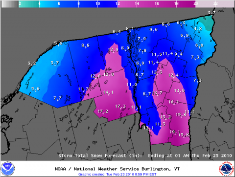
-
TEMPETES POTENTIELLES 23-26 FÉVRIER 2010
iceberg a répondu à un(e) topic de Pierre dans Discussions générales
Je veux être positve 15 à 20 cm pour Montréal de ce soir jusqu'à demain soir. -
TEMPETES POTENTIELLES 23-26 FÉVRIER 2010
iceberg a répondu à un(e) topic de Pierre dans Discussions générales
22-28 FEV 1969. 41e anniversaire Cela a été une tempête inhabituelle en raison de son mouvement lent, une longue durée, modéré l'intensité, l'intensification erratique, manque de contraste thermique importante à la surface, et le niveau supérieur chaotique géopotentiel tempête hauteur patterns.Des quantités excessives de neige à travers la Nouvelle-Angleterre.Régions avec des accumulations de neige supérieure à 50 cm. Nord-est du Vermont, du New Hampshire et la plupart du Maine. MT. WASHINGTON- NH...248 CM PINKHAM NOTCH- NH.....196 CM LONG FALLS DAM- ME.....142 CM BOSTON- MA.......67 CM PORTLAND- MA.......68 CM MONTREAL- QUE.....16 CM 14-17 Fev 1958 52e anniversaire Le blizzard de la tempête de 58 a été très large diffusion qui a produit des accumulations de neige de plus de 25 cm de l'Alabama au Québec. Washington DC .... 37 cm Baltimore ............ 39 cm Philadelphie ........ 33 cm new york city ...... 26 cm Boston ............... 49 cm Callicoon ny ....... 98 cm NY Rochester ...... 78 cm Syracuse NY ...... 67 cm Albany NY .......... 46 cm Montreal Que ..... 44 cm Avec la 2em tempête de cette semaine si tous les ingrédients viennent jouer pourrions-nous obtenir 40 cm de neige en 3 jours ? -
TEMPETES POTENTIELLES 23-26 FÉVRIER 2010
iceberg a répondu à un(e) topic de Pierre dans Discussions générales
Je vais aller à l'extérieur nu si nous obtenons plus de 50 cm de neige ce week-end. A second storm will begin to take shape off the East Coast on Thursday. This storm will then turn northwestward toward New England Thursday night as it rapidly intensifies into a monster storm. The worst of the storm, in terms of snowfall, will likely be from upstate New York through southern Quebec and into northern Maine, where up to 2 feet of snow could accumulate by Saturday morning. In addition to the heavy snow, strong winds will create blizzard conditions across this region with widespread blowing and drifting of snow. Travel across this region will be severely impacted with some road closures and near-zero visibility. Enough warm air coming in off the ocean should cause most of the precipitation to fall as rain from eastern New England through the Canadian Maritimes. accuweather...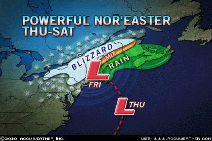
-
DISCUSSIONS PRÉVISIONS de 22 au 28 fév 2010
iceberg a répondu à un(e) topic de Trapper dans Discussions générales
Je pense qu'un épisode pluvieux la semaine prochaine diminuera à mesure que les modèles vont se mettre à d'accord. THE POTENTIAL EXISTS FOR A PROLONGED PERIOD OF UNSETTLED WEATHER FROM TUESDAY THROUGH FRIDAY...MAINLY IN THE FORM OF SNOW. THERE IS ALSO THE POTENTIAL FOR A SIGNIFICANT SNOW EVENT FROM TUESDAY NIGHT THROUGH THURSDAY...AS A LOW PRESSURE AREA DEVELOPS OFF THE MID ATLANTIC COAST LATE TUESDAY NIGHT AND THEN MOVES NORTHEAST TOWARD NEW ENGLAND ON WEDNESDAY. THERE IS STILL SOME UNCERTAINTY AMONG THE MODELS AS TO THE TIMING OF THIS PRECIPITATION EVENT...AND THE EXACT TRACK OF THE LOW PRESSURE AREA. THE NATIONAL WEATHER SERVICE IN BURLINGTON WILL CONTINUE TO MONITOR THIS SITUATION CLOSELY OVER THE NEXT SEVERAL DAYS. NOAA... -
Le jour de la marmotte, un mythe ou une réalité?
iceberg a répondu à un(e) topic de Jean-Marc dans Discussions générales
Une perte de temps........ -
Observation du 26 au 31 janvier 2010
iceberg a répondu à un(e) topic de Pierre dans Discussions générales
Tn -21.7, le plus froid de l'hiver à date ce matin 7:23am. -
UN NOUVEAU RECORD DU MONDE DE VITESSE DU VENT à 408 km/h VOICI LE LIEN..... http://www.wmo.int/pages/mediacentre/infon...info_58_en.html
-
Une tornade a touché le sol, très rare dans la zone de Contra Costa Bay area. VOICI LE LIEN..... http://www.sfgate.com/cgi-bin/article.cgi?.../BAE11BMLH6.DTL
-
Températures froides en Floride
iceberg a répondu à un(e) topic de Yannis30 dans Discussions générales
Meme en Cuba le froid a fait des mort... Cuba cold snap kills 26 at psychiatric hospital AP Published Friday, January 15, 2010 HAVANA (AP) Twenty-six patients at Cuba's top hospital for the mentally ill died this week during a cold snap, the government said Friday. Human rights leaders cited negligence and a lack of resources as factors in the deaths, and the Health Ministry launched an investigation that it said could lead to criminal proceedings. A Health Ministry communique read on state television blamed "prolonged low temperatures that fell to 38 degrees Fahrenheit (4 Celsius) in Boyeros," the neighborhood where Havana's Psychiatric Hospital is located. It said most of the deaths were from natural causes like old age, respiratory infections and complications from chronic diseases including cancer and cardiovascular problems. But the statement corroborated reports from the independent Cuban Commission on Human Rights that least 24 mental patients died of hypothermia, and that the hospital did not do enough to protect them from the cold because of problems such as faulty windows. Commission head Elizardo Sanchez said that so many patients dying of hypothermia was "absurd in a tropical country" and claimed the deaths could have been prevented if the government had granted long-standing requests from international aid groups to tour Cuba's medical facilities, including the capital's 2,500-bed mental hospital. The Health Ministry said a commission created to investigate has already identified various deficiencies. Communist Cuba provides free health care to all its citizens but, though the quality of its medical system is celebrated in leftist circles around Latin America, it is also plagued by shortages. Patients are expected to bring their own sheets and towels and sometimes their own food during hospital stays. Cuba blames the shortages on the U.S. trade embargo, though it does not prevent the direct sale of medicine or medical supplies to the island. Copyright 2010 The Associated Press.