iceberg
-
Compteur de contenus
1 349 -
Inscription
-
Dernière visite
-
Jours gagnés
47
Type de contenu
Profils
Forums
Events
Gallery
Tout ce qui a été posté par iceberg
-
Well yes indeed our summer has come and gone, June and July were marked by cool and cloudy days with some showery periods here and there, August was a normal month for temps and precip. Here is a link from Noaa on this summer's tale. http://www.noaanews.noaa.gov/stories2009/2...ummerstats.html
-
For Montreal the record is 17 days. August into September of 1957. That month of August only 0.5mm of rain fell. http://www.climate.weatheroffice.ec.gc.ca/...7&Month=8&Day=1
-
WELL HERE IT IS, THE PERFECT PLACE TO DO STAR GAZING !!! http://www.livescience.com/environment/090...est-driest.html
-
Current - Courant - Observation : 8:24PM EST AUG 23, 2009. Place: Montreal-East Obs: thundershowers Temp: 22.7c Hudex: 28.9c Dew: 18.8c Wchill: 227.c Hum: 80% Wind: 14.8km/h NE (LIGHT BREEZE) Gust: 18.4km/h Pres: 1014.3 hpa ® Rain: 1.5mm last 24HRS Clbase: 1508 FEET
-
Prévisions et observation 20 - 21 aout
iceberg a répondu à un(e) topic de stefano dans Discussions générales
THE ENERGY CELL IS JUST PASSING BY KINGSTON, ONTARIO AS YOU COULD OBSERVE ON THE RADAR MAP. http://www.rap.ucar.edu/weather/radar/disp...e=-1&duration=0 -
Prévisions et observation 20 - 21 aout
iceberg a répondu à un(e) topic de stefano dans Discussions générales
TORNADO WARNING IN EFFECT FOR PETERBOROUGH, ONTARIO. THIS COLD FRONT MEANS BUISNESS.... http://www.weatheroffice.gc.ca/city/pages/...1_metric_e.html -
PRÉVISIONS ET OBSERVATIONS 18 AOÛT 09
iceberg a répondu à un(e) topic de Pierre dans Discussions générales
Current - Courant - Observation : 3:42PM EST AUG 18, 2009. Place: Montreal-East Obs: Light rainshower Temp: 28.1c Hudex: 36.9c Dew: 21.4c Wchill: 28.0.c Hum: 68% Wind: 29.5km/h WNW (MODERATE BREEZE) Gust: 39.2km/h Pres: 1010.9 hpa (F) Rain: TRACE LAST 24HRS Clbase: 2719 FEET -
Observation 9 et 10 août 2009
iceberg a répondu à un(e) topic de castor028 dans Discussions générales
Current - Courant - Observation : 10:23PM EST AUG 09, 2009. Place: Montreal-East Obs: Cloudy Temp: 22.1c Hudex: 22.9c Dew: 17.7c Wchill: 22.1.c Hum: 76% Wind: 6.1km/h WNW (LIGHT BREEZE) Gust: 9.7km/h Pres: 1006.5 hpa (F) Rain: NIL LAST 24HRS Clbase: 1849 FT STATION MAKE: RAINWISE MK-III LR -
FROM WHAT I READ WE WILL NOT REACH THE RECORD MINIMUM SET IN 2007. THERE ARE MANY REASONS FOR THIS AND ONE OF THOSE REASONS ARE THE LOW SUN SPOT ACTIVITY AS IT EFFECTS THE POLAR VORTEX IN HIGH ALTITUDE. MAYBE SOME PEOPLE WILL NOT AGREE. HERE ARE SOME LINKS ON THE OUTLOOKS. A FORUM IN FRANCE ON THE MATTER AND S-E-A-R-C-H. http://forums.infoclimat.fr/index.php?showtopic=40159&st=0 http://www.arcus.org/search/seaiceoutlook/...report_july.php
-
A NEW RECORD WILL BE SET THIS MONTH FOR LEAST AMOUNT OF SUNSHINE FOR MONTREAL. WE ARE AT 198 HOURS OF SUNSHINE WITH 2 DAYS LEFT. SO FAR WE HAD 18 DAYS WITH MAX TEMP BELOW 25C. THE RECORD IS 230 HOURS SET IN JULY OF 1992.
-
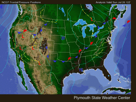
Prévisions et observations Dimanche 26 Juillet
iceberg a répondu à un(e) topic de marcrem dans Discussions générales
THE NEXT CELL IS HEADING FOR BOUCHERVILLE.... -
Prévisions et observations Dimanche 26 Juillet
iceberg a répondu à un(e) topic de marcrem dans Discussions générales
Verchère c'est ou par rapport à St Hyacinthe ? 40km au nord-ouest de ste-hyacinthe YOUR NEXT EROL.. CA VA BRASSER..... -
Prévisions et observations Dimanche 26 Juillet
iceberg a répondu à un(e) topic de marcrem dans Discussions générales
Dans les prochain 10 minutes..... -
Prévisions et observations Dimanche 26 Juillet
iceberg a répondu à un(e) topic de marcrem dans Discussions générales
You lucky bum Shawn, the cell just moved north of St. Leonard and Anjou and you got the bulls eye.... -
Prévisions et observations Dimanche 26 Juillet
iceberg a répondu à un(e) topic de marcrem dans Discussions générales
D'où viennent ces infos ? As-tu un lien ? Merci ! HERE YOU GO FOLLOW THE LINK... LIEN... http://www.intellicast.com/Local/Map.aspx?location=USNY0124 -
Prévisions et observations Dimanche 26 Juillet
iceberg a répondu à un(e) topic de marcrem dans Discussions générales
THE SEVERE CELL JUST MOVED NORTH OF ST. LEONARD TOWARD MONTREAL NORTH HEADING FOR RDP........ 9MM 0F RAIN IN 13 MINUTES... NOTHING SPECTACULAR OUT OF THIS... -
Prévisions et observations Dimanche 26 Juillet
iceberg a répondu à un(e) topic de marcrem dans Discussions générales
3 MIN TO IMPACT ON SEVERE CELL FOR ANJOU AND ST. LEONARD.... -
Prévisions et observations Dimanche 26 Juillet
iceberg a répondu à un(e) topic de marcrem dans Discussions générales
A SEVERE CELL TO REACH ST. LEONARD AND ANJOU BY 10:30 PM...... 4.2 MM OF RAIN SO FAR IN JUST OVER 3 MIN...... -
Prévisions et observations Dimanche 26 Juillet
iceberg a répondu à un(e) topic de marcrem dans Discussions générales
INTENSE LIGHTING OVER ST. LEONARD AND ANJOU ..... MORE TO FOLLOW........ -
Prévisions et observations Dimanche 26 Juillet
iceberg a répondu à un(e) topic de marcrem dans Discussions générales
METRO MONTREAL - LAVAL 9:58 PM EDT SUNDAY 26 JULY 2009 SEVERE THUNDERSTORM WARNING FOR METRO MONTREAL - LAVAL CONTINUED THE AIRPORT IN DORVAL HAS NOW A SEVERE THUNDERSTORM.... -
Prévisions et observations Dimanche 26 Juillet
iceberg a répondu à un(e) topic de marcrem dans Discussions générales
The rain band has now reached St. Leonard and Anjou with lighting and thunder. -
Prévisions et observations Dimanche 26 Juillet
iceberg a répondu à un(e) topic de marcrem dans Discussions générales
The outer edge of the rain band has now reached the auto 13 and Ville La Salle..... You could follow it live with the interactive radar map from intellicast...... http://www.intellicast.com/Local/Map.aspx?location=USNY0124 -
Prévisions et observations Dimanche 26 Juillet
iceberg a répondu à un(e) topic de marcrem dans Discussions générales
Current - Courant - Observation : 19:36PM EST JULY 26, 2009. Place: Montreal-East Obs: Cloudy Temp: 19.3c Hudex: 24.6c Dew: 17.1c Wchill: 19.3.c Hum: 87% Wind: 6.1km/h SE Gust: 9.7km/h Pres: 1009.8 hpa (S) Rain: 9.0mm last 24 hours Weather notes: The high temp so far today was 20.8c reached at 17:01PM. A cool and very humid day was observed at the station...... -
3000 temp records broken for July !!!! Really amazing stats...... heres the link lien .... http://iceagenow.com/3000_low-temp_records_for_July.htm
-
Prévisions et observations Dimanche 26 Juillet
iceberg a répondu à un(e) topic de marcrem dans Discussions générales
Hello Shawn, That indeed is the cool front but it will have a hard time reaching the Montreal area as a block is set up to the North East of the province and low pressure area will move to the hudson bay region and become stationary there.. Embedded storm cells will hit or miss Southern Quebec the next 48 hours...