iceberg
-
Compteur de contenus
1 349 -
Inscription
-
Dernière visite
-
Jours gagnés
47
Type de contenu
Profils
Forums
Events
Gallery
Tout ce qui a été posté par iceberg
-
Observations des 14-15 et 16 janvier
iceberg a répondu à un(e) topic de Tornade dans Discussions générales
current - courant - observation : 22:48pm EST Montreal-est nuageux -21.0c Montreal-east cloudy -21.0c Plus froid -coldest- temperature aux monde- on the planet. Oymyakon, Russia: -54.5c Plus chaude- warmest-temperature aux monde- on the planet. PENRITH AUSTRALIA: 41.7°c RADAR: http://www.intellicast.com/National/Radar/...cation=USVT0147 -
DISCUSSIONS ÉVÉNEMENTS du 12 au 18 janvier 2009
iceberg a répondu à un(e) topic de Trapper dans Discussions générales
5 TO 10cm of snow for the Montreal area. Closer to the 5cm is more reasonable. This graph is from COLA:
-
Conférence sur les changements climatiques en Pol.
iceberg a répondu à a topic dans Discussions générales
I dont think you understand Regg whats going on. 1. Most weather stations are on urban territory. lots of black pavement there. 2. Most weather stations are out of date and not working properly. budget cuts. 3. 70% of the earth is coverd by water, we dont have weather stations covering all the surfaces of the ocean. lots of missing data there. lots of false data Regg. Iceberg, 1- Si l'étallement urbain est aussi important que tu le supposes autour des stations d'observation, alors les mesures de température aux stations ne représentent pas bien, en moyenne, les températures au sol (ou à 2 mètres). Peux-tu appuyer cette affirmation par une étude de terrein qui la démontrerait, sur une région particulière assez grande (comme le Québec) ? [En passant, cette hypothèse est intéressante pour une autre raison : elle expliquerait peut-être (en partie) pourquoi les passes de 06Z et 18Z des modèles (GFS, NAM) sont moins précises que celles de 12Z et 00Z. En effet, l'étallement urbain affecte surtout les températures au sol (et moins celles en altitude). Or (si ça n'a pas changé) les seules nouvelles données intégrées aux modèles lors des passes 06Z et 18Z sont justement les mesures au sol. (Fin du hors sujet)] 2- En l'absence de plus d'information, il est raisonnable de supposer que les erreurs de mesure de la température dues à la désuétude des appareils sont aléatoires et affectent les mesures autant positivement que négativement. Im not the only one saying it that urban heat is also accounted for in the global warming average temps that are being given out by the WMO.Which in turn is wrong. http://wattsupwiththat.com/2008/08/23/how-...rature-part-69/ -
Conférence sur les changements climatiques en Pol.
iceberg a répondu à a topic dans Discussions générales
So far the WMO has been wrong in there forcast and the proof is here. http://icecap.us/images/uploads/icecap10012009.pdf -
Conférence sur les changements climatiques en Pol.
iceberg a répondu à a topic dans Discussions générales
Si réchauffement climatique il y a (et je crois bien qu'il a lieu), alors il se superpose (grosso modo) aux cycles naturels. Que la couverture glacière du Groenland augmente actuellement s'inscrit à l'intérieur des cycles naturels et ne prouve rien. Si elle augmente pour les 30 prochaines années, alors on en reparlera. Le Groenland se trouve à un endroit où les précipitations de neige l'hiver sont particulièrement abondantes. Il suffit qu'elles dépassent la fonte l'été pour que la masse de glace augmente. La Terre pourrait très bien se réchauffer et les glaces du Groenland augmenter. Même réflexion pour les glaces du pôle sud. Thats right Wave, more snow which means more sun light deflected out in outer space which in turn means more cold air the atmoshphere will hold.Less melting also will take place. -
Conférence sur les changements climatiques en Pol.
iceberg a répondu à a topic dans Discussions générales
Another report that greenlands glaciers have slowed down there melting. Again pointing out that its not global warming but rather a cycle. http://news.yahoo.com/s/afp/scienceclimate...nland_newsmlmmd -
Conférence sur les changements climatiques en Pol.
iceberg a répondu à a topic dans Discussions générales
I dont think you understand Regg whats going on. 1. Most weather stations are on urban territory. lots of black pavement there. 2. Most weather stations are out of date and not working properly. budget cuts. 3. 70% of the earth is coverd by water, we dont have weather stations covering all the surfaces of the ocean. lots of missing data there. lots of false data Regg. -
ENSO (El Niño-Southern Oscillation)
iceberg a répondu à un(e) topic de uranium dans Discussions générales
Well i think they could take there report and put it in the garbage pail beacuse 2009 will not be 5th warmest like they predict, and Regg dont be brain washed like lots of people.We shall see at the end of 2009,if temps are above normal i will retire from my weather hobby that im in. -
This cold outbreak that will come our way was not seen since 1994 and i do remember that January month it was brutal !! http://www.accuweather.com/news-top-headli...ner=accuweather
-
ENSO (El Niño-Southern Oscillation)
iceberg a répondu à un(e) topic de uranium dans Discussions générales
This is a cycle that we are entering in. A cold cycle like the 1960s and 1970s.We shall see this year what mother nature brings us and if we still get a cool summer and cold temps being broken then we have to ask ourselves where is this global warmimg !! -
ENSO (El Niño-Southern Oscillation)
iceberg a répondu à un(e) topic de uranium dans Discussions générales
CANADA ALSO IN A BRUTAL COLD SNAP !!! http://www.canada.com/saskatoonstarphoenix...1c-8584a406604d New Dalton minimum on the way? If you think solar activity controls the climate (as I do), then you must see this graph indicating that a new Dalton minimum is on the way. http://www.vukcevic.co.uk/GrandMinima.gif -
ENSO (El Niño-Southern Oscillation)
iceberg a répondu à un(e) topic de uranium dans Discussions générales
Madrid airport closed as Europe freezes 10 Jan 09 - Look at the spin at the end of the article! - Nearly 400 km (250 miles) of traffic jams in and around the Spanish capital. - Several rivers in Germany frozen - Much of Europe enduring Siberian conditions. - Days of heavy snow in France's southern Marseille region -- not seen for 20 years -- causing major disruption to travel. - Germany experiencing one of its coldest winters in 100 years - several rivers frozen over, blocking ship traffic thermometer plunges to minus 34.6C (minus 30.3F) in the mountains in the south. - Drift ice covers 80 to 90 percent of the surface of the river Elbe from Doemnitz to Germany's main port of Hamburg. And now comes the spin: The World Meteorological Organization said Europe's severe cold spell was in part brought on by La Nina, an upsurge of cooler water to the Pacific Ocean surface. "However, it should be recalled that weather conditions are the result of extremely complex interactions, and, therefore, one particular event cannot be attributed to one specific cause," the UN weather agency said. How about attributing it to the ice-age cycle? http://news.yahoo.com/s/afp/20090109/wl_af...ather_newsmlmmd -
ENSO (El Niño-Southern Oscillation)
iceberg a répondu à un(e) topic de uranium dans Discussions générales
Brazil summer temps coldest in 99 years 9 Jan 09 Excerpts Ive been hearing about the dry weather in the south of Brazil. Although I knew the reports were accurate, it was still hard to believe ... So I decided to get a first-hand weather report from Eroni Paniz, our Cropwatcher from Brazils southernmost state Rio Grande do Sul. His report: It was a dry winter! In the spring, we had a strong rain, and after that, in October and November, we got nearly nothing. Its really strange, as it rains torrentially in the middle of the state but on the extremities, nothing. I guess that, between the two, I would pick drought over floods at least with droughts you dont lose everything you own. But, with floods, everything can get washed away. I think that a good portion of the grain crop will decrease in size, mainly the corn and edible beans that were hit hard. According to what Ive heard, we should suffer a loss of around 25 percent. The livestock sector is taking it in the face! The forecast isnt good, with just a few, sparse rains not big enough to get a whole farm wet. Weve had cold weather for this time of year its been 99 years since we have had such cold temperatures during the period of the year, and Im not sure how long its been since weve had such a bad drought. Its really strange; when it should be cold, its hot enough to fry an egg. And vice versa. Theres no explaining it. A PRESSE.... Very strange indeed could it be la nina having an affect in Brazil too ? -
DISCUSSIONS ÉVÉNEMENTS du5 au 11 janvier 2009
iceberg a répondu à un(e) topic de Trapper dans Discussions générales
Le dernier run GEM REG et GFS 00z remonte la depression beaucoup plus au nord. Elle passe tout just a la frontiere. A surveiller IF THE SYSTEM MOVES A BIT MORE NORTH IT COULD GIVE MONTREAL 2 TO 5 CM. -
Conférence sur les changements climatiques en Pol.
iceberg a répondu à a topic dans Discussions générales
Mon pauvre Maxime, ça ne se fait pas des moyennes de moyennes - math 101 . Je ne vois pas pourquoi tu ramènes l'histoire des orages ou des ouragans - ce n'est pas le sujet de discussion. Finalement tu relates plein d'évènements ponctuels alors qu'on parle d'un phénomène qui s'étant sur des dizaines et centaines d'années. Et si tu doutes de l'aspect réchauffement, va voir ceci : 2008 S'INSCRIT AU NOMBRE DES DIX ANNÉES LES PLUS CHAUDES de l'OMM . Hello Reg Im not saying that you are wrong but you will have too look at the other side too. Im leaving this link here and tell me what you think. http://icecap.us/images/uploads/DataIntegrity.doc -
What your mom saw this morning Marc is called a sun dog. Sun dog From Wikipedia, the free encyclopedia Jump to: navigation, search For other uses, see Sun dog (disambiguation). Pronounced sun dogs on both sides of a setting sun in New Ulm, Minnesota. Note the halo arcs passing through each sun dog. An elongated parhelion alongside the sun, unseen at the left Sundog in central Iowa, exhibiting rainbow colorsA sun dog or sundog (scientific name parhelion, plural parhelia, for "beside the sun") is a common bright circular spot on a solar halo. It is an atmospheric optical phenomenon primarily associated with the reflection or refraction of sunlight by small ice crystals making up cirrus or cirrostratus clouds. Often, two sun dogs can be seen (one on each side of the sun) simultaneously.
-
Vague de froid en France et NO de l'Europe
iceberg a répondu à un(e) topic de Tyrone dans Discussions générales
Spain: Heavy Snowfall MADRID, Jan 9, 2009 (AFP) - Heavy snowfall disrupted road transportation on Friday in central Spain and forced the closure of Madrid's international airport as a cold spell grips much of Europe, officials said. All four runways at Madrid's Barajas airport, one of Europe's busiest, closed at 11:50 am (1050 GMT) and will remain shut until further notice because of the rare snowfall, the national airport authority AENA said. "There are no arrivals, there are no departures," a spokeswoman for the authority told AFP. By late morning nearly 400 kilometres (250 miles) of traffic jams were recorded around the Spanish capital, causing headaches for thousands of drivers, and dozens of accidents and collisions were reported. "Traffic is very difficult in the centre of Spain, many roads are cut especially in the Madrid region where it is recommended not to drive," a spokesman for the interior ministry's traffic management agency DGT told AFP. Office workers gathered at building entrances and windows in Madrid to watch the snow fall while others staged snowball fights on city sidewalks. The snowfall was accompanied by temperatures that could drop as low as minus seven degrees Celsius (19 degrees Fahrenheit), the national weather office said. A PRESSE ACCUWEATHER JOE BASTARDI DID SAY THAT EUROPE WOULD HAVE A MAJOR COLD SNAP ON DECEMBER 19TH,2008. Current temp at 8:49pm EST FOR SPAIN Logrono (363 m) 1° overcast, mist Vigo/Peinador (255 m) 0° few clouds, mist Vitoria (510 m) 0° cloudy Madrid/Barajas (582 m) -1° light snow Cordoba (92 m) -1° - Moron (88 m) -1° dry Madrid / Torrejon (611 m) -2° light snow Jerez de la Frontera (28 m) -2° - La Coruna (67 m) -2° - Salamanca (794 m) -3° light snow Albacete (704 m) -4° freezing fog Granada AP (570 m) -4° - Santiago/Labacolla (367 m) -5° fog in patches -
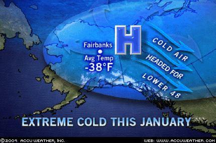
Yes the cold will hit also the big cities in the north east like New York City a -18c at night. Fairbanks, Alaska, is a mighty cold place in January. The normal daily average temperature this time of year is 10 below zero. Now, try this one on for size. In Fairbanks this month, the average temperature has been 38 degrees below zero! Do the math. Actually, the cold in Alaska is just part of a mammoth arctic air mass that extends across all of northern Canada. So what will become of this intense cold? Well, here's the bad news. Next week, a broad northwesterly flow from the Arctic all the way to the Gulf of Mexico is going to bring a huge amount of that bitter air down. It's the type of cold that really stings. Later in the week, below zero temperatures are expected from the Midwest to the Northeast. Chicago will most certainly experience a period when the temperature stays below zero. New York could also have a below-zero night, which hasn't happened in 14 years. Story by AccuWeather.com Senior Meteorologist John Kocet.
-
Un dur hiver à venir ? hard winter to come ?
iceberg a répondu à un(e) topic de iceberg dans Discussions générales
NOAA REPORT FOR 2008 AND DECEMBER WAS BELOW NORMAL FOR THE FIRST MONTH OF WINTER TEMP WISE. http://www.noaanews.noaa.gov/stories2009/2...emberstats.html -
SUJET POUR LE FROID INTENCE POUR LA SEMAINE PROCHAINE.
-
ENSO (El Niño-Southern Oscillation)
iceberg a répondu à un(e) topic de uranium dans Discussions générales
Surprising Return of North Atlantic Circulation Pump. http://media-newswire.com/release_1083196.html Not surprising i say since ocean temps were below normal in the north atlantic since about 7 years when it last happened.But the main reason are the winds aloft which brought the cold air and and storms made a southerly track via the labrador current so waters were kinda stable along the north atlantic. -
ENSO (El Niño-Southern Oscillation)
iceberg a répondu à un(e) topic de uranium dans Discussions générales
Alaska makes the headlines. http://news.yahoo.com/s/ap/20090108/ap_on_...ka_extreme_cold This frigid air will make its way southeast into the lower 48 the next 10 days or so. We will making the news like Europe and Alaska/Canada has in recent weeks. Could make things interesting come Inauguration Day. -
Vague de froid en France et NO de l'Europe
iceberg a répondu à un(e) topic de Tyrone dans Discussions générales
Current temp for France selected cities ( 10:32 EST ) Poitiers/Biard (120 m) -10.0° Melun (92 m) -10° Metz-Nancy-Lorraine (264 m) -10° Le Puy/Loudes (833 m) -10.3° Luxeuil (273 m) -11° Cambrai (77 m) -11° Metz/Frescaty (192 m) -11° Colmar (220 m) -11° Nancy/Ochey (351 m) -11.1° Strasbourg/Entzheim (153 m) -11.1° Troyes/Barberey (118 m) -12.0° Beauvais/Tille (111 m) -13° Warmest: Figari (23 m) 10° -
Conférence sur les changements climatiques en Pol.
iceberg a répondu à a topic dans Discussions générales
Ok, mais ce n'est seulement qu'une hypothèse. Les pôles vont très bien cette année, les glaces du pôle nord sont au meme niveau quand 1979. Je crois que les prévision sur 100 ans sont faites sur une trop longue période. Si on veut des prévisions, 10 à 30 ans serait la bonne option, et les vérifications seraient plus faciles alors on pourrait mieux se préparer que de toujours se baser sur le 100 ans. 100 ans sera toujours 100 ans si on le dit à chaque année. The ice could be at the same level like in 1979 . But you must understand how much thick years old ice is there. As the sun set in the Arctic with the advent of autumn, seasonal ice growth was initially quite rapid, but slowed during early November. Average ice extent in December was well below average and very close to that measured in 2007. Heading into 2009, the Arctic sea ice cover is again young and thin; given this set-up, a continuation of well-below-average sea ice extent in 2009 is a near certainty.
-
DISCUSSIONS ÉVÉNEMENTS du 12 au 18 janvier 2009
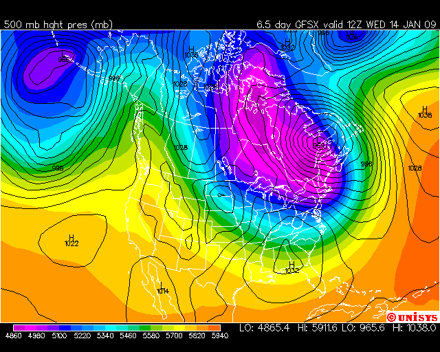
iceberg a répondu à un(e) topic de Trapper dans Discussions générales
From Accu Weather, B. Anderson Storm potential early next week Early next week, a tremendous amount of jet stream energy will be diving into eastern North America as the overall pattern across North America really starts to amplify. With all this energy coming toward the East Coast, there should be a storm developing off the Northeast coast of the United States sometime Tuesday. The big questions are where will this storm initiate and how fast does it intensify. Computer models are still unsure on whether or not all this energy comes together (phases) and leads to a major coastal storm. The European model seems to be the strongest, showing a rapidly deepening storm east of Cape Cod, Mass., Tuesday evening and taking it up through the Maritimes early Wednesday as a monster storm. The American model keeps the energy unphased for a longer period, leading to a slower developing storm and one that probably tracks farther out to sea. I am leaning toward the European model at this point, since I think there will be a tremendous amount of potential on the weather map Tuesday with the strong jet and the Arctic air poised to sweep in on the back side of the storm. I favor the region from eastern Maine through southern and central New Brunswick, through northern Nova Scotia as the area that could get a major snowstorm late Tuesday through early Wednesday. I think the storm may end up developing too far north to have much impact on the Middle Atlantic and southern New England region. Once this storm moves by, regardless of what model is right, strong northwest winds will usher in much colder air across eastern Canada, with the main surge of bitterly cold air getting in later Thursday and into the weekend. By the way, the core of the cold will be over the heart of the Prairies on Wednesday with sub -30 c temperatures as a 1050+ mb Arctic high builds in. NOW THE MODELS ARE ALL OVER THE PLACE WITH THIS ONE AND STILL TO EARLY TO TELL BUT ITS A 50/50 CHANCE THAT THIS MONSTER STORM COULD DEVELOP. IT WILL ALL DEPEND ON THE TIMING AND ENERGY PHASES LIKE BRETT SAID, IF IT ALL COMES TOGETHER. NOW IF IT WILL IMPACT SOUTHERN QUEBEC IT WILL ALL DEPEND ON HOW FAR WEST THE STORM WILL DEVELOP.