iceberg
-
Compteur de contenus
1 349 -
Inscription
-
Dernière visite
-
Jours gagnés
47
Type de contenu
Profils
Forums
Events
Gallery
Tout ce qui a été posté par iceberg
-
Pour la grande region de Montreal les rafales de vent peut atteindre 100km/h apres minuit. For the greater Montreal area wind gusts could reach 100km/h after midnight.
-
Observations système 24-25et 26 décembre 2008
iceberg a répondu à un(e) topic de Trapper dans Discussions générales
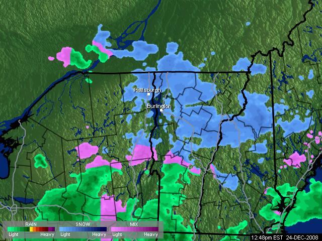
MONTREAL-EST NEIGE FAIBLE -1.3C 1:05PM MONTREAL-EAST LIGHT SNOW -1.3C 1:05PM RADAR:
-
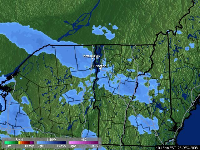
Observations système 24-25et 26 décembre 2008
iceberg a répondu à un(e) topic de Trapper dans Discussions générales
Montreal-est Nuageux -6.3c 10:39pm Montreal-east cloudy -6.3c 10:39pm radar:
-
I agree with you Nicolas the models now are dancing around and everyone has a diff outlook, in reality no one can pinpoint where the snow rain line will be.
-
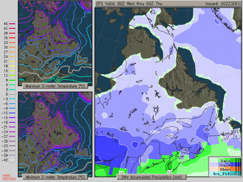
Brett anderson accuweather thinks different !! Breakdown on this event for selected sites...... Windsor, Ont.....5-8 cm snow tonight then a mix late tonight followed by rain Wednesday morning. London, Ont.....8-14 cm of snow tonight and Wednesday morning then some sleet/ice followed by rain later Wednesday morning. Hamilton, Ont....8-12 cm snow into Wednesday morning then a brief period of sleet/ice followed by rain midday Wednesday. Kitchener, Ont...12-18 cm of snow through Wednesday morning then sleet/ice followed by rain Wednesday afternoon. Toronto, Ont.....10-16 cm snow into Wednesday morning then some sleet/ice later in the morning followed by afternoon rain. Owen Sound, Ont......10-17 cm snow tonight through Wednesday morning, changing to sleet then rain Wednesday afternoon. Barrie, Ont....12-20 cm snow tonight through midday Wednesday then some sleet/ice followed by rain late in the day. North Bay, Ont.....15-25 cm snow tonight through Wednesday night. Some sleet possible late Wednesday. Sault Ste. Marie......13-23 cm snow Peterborough, Ont...12-18 cm snow through Wednesday morning then sleet/ice midday Wednesday then a cold rain late Wednesday. Kingston, Ont......10-15 cm snow into midday Wednesday then sleet/ice to rain in the afternoon. Ottawa, Ont.....10-17 cm snow into early Wednesday afternoon then sleet/ice late Wednesday before going back to snow late Wednesday eve. Montreal, Que......8-15 cm snow through Wednesday afternoon then sleet/ice Wednesday evening which changes to plain rain Wednesday night, but just barely! Storm back to snow late Wednesday night before ending. Quebec City, Que....6-12 cm snow through Wednesday evening then sleet/ice Wednesday night for a time before going back to snow early Thursday morning.
-
Just confirmed with EC 6 cm of snow then to all rain but i think we will get up to 10 cm of snow for Montreal.
-
The grids from COLA offer 10cm to 15cm then to straight rain for Montreal.
-
Un dur hiver à venir ? hard winter to come ?
iceberg a répondu à un(e) topic de iceberg dans Discussions générales
Im dreaming of a white christmas !!! just ask Irving Berlin in 1940 who wrote the song.. link.. lien.. http://uk.reuters.com/article/burningIssue...E4BL1AD20081222 -
Un dur hiver à venir ? hard winter to come ?
iceberg a répondu à un(e) topic de iceberg dans Discussions générales
The last real Christmas snow storm was in 1966 with 32.8 cm. If Patito is right will be 7 cm shy of breaking the record for the date for montreal. this is the link... voici le lien pour la date... http://www.climate.weatheroffice.ec.gc.ca/...Month=12&Day=21 -
Un dur hiver à venir ? hard winter to come ?
iceberg a répondu à un(e) topic de iceberg dans Discussions générales
Yes 98% of Canada will have a White Noel http://www.ctv.ca/servlet/ArticleNews/stor...hub=CTVNewsAt11 -
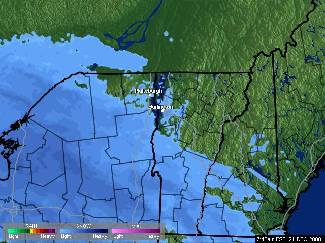
OBSERVATIONS 21 ET 22 DÉCEMBRE 08
iceberg a répondu à un(e) topic de Pierre dans Discussions générales
I think i know where he comes from. Quaqtaq is a village in far Northern Quebec . http://en.wikipedia.org/wiki/Quaqtaq,_Quebec http://fr.wikipedia.org/wiki/Quaqtaq PS.. I HOPE HE HAS A GENERATOR TO RUN HIS LAP TOP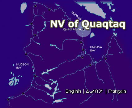
-
Un dur hiver à venir ? hard winter to come ?
iceberg a répondu à un(e) topic de iceberg dans Discussions générales
I think that January will be a normal month temp wise for Southern Quebec before it turns colder again late January and Feb. this is from lundbergs blog... Bitter Cold To Be Bottled Up For a Time Monday, 11:30 A.M. The one-two punch of storms that moved across the Midwest and Great Lakes into the Northeast over the past few days has helped pull a strong cold front right off the Gulf Coast, through The Valley, off the East Coast, and down through Florida in the past 24 hours or so, and it is an impressive cold front, indeed! Wind chills along the Gulf coast were close to 10 degrees this morning, and temperatures during the daylight hours stayed below zero in Chicago yesterday! Just as impressive was the dump of snow with these two storms. While northern New England, specifically Maine, largely missed out on all the fun with the first storm, they were walloped with the second one. I think I got my two feet of snow through the weekend, only it was solely with storm number two in parts of Maine! Regardless, there is a carpet of white on the ground now that's not going away any time soon, certainly not through Christmas in most of the areas that cashed in on the snow. Check out the latest snow cover: http://www.weatheroffice.gc.ca/data/analysis/352_50.gif There is one little problem, though. There remains up to now no reasonable form of blocking downstream, as evidenced by a positive North Atlantic Oscillation: http://www.cpc.ncep.noaa.gov/products/prec...index_ensm.html Without out that, the cold can certainly come if other things upstream are conducive for it, but there's no way to sustain that cold. We have seen this time and time again over the past few weeks, especially this month. No doubt the cold overall has won the war in a lot of places, but these spikes of warmth keep occurring, and another couple are on the way as we head to and beyond Christmas. If you look at the ensemble forecasts of the NAO, though, what should catch your eye is the negative trend going forward. That suggests to me that if there's more cold air in the pipeline after the nice warm period across the South and into the East, that it will come, and may actually stick around for more than a few days at a time. Even the Arctic Oscillation is being forecast to turn very negative as we head into the New Year, a signal of renewed pulses of bitter after this period of relaxation in the pattern occurs. http://www.cpc.ncep.noaa.gov/products/prec...ex/ao.sprd2.gif Should that occur as expected, and I have good reason to doubt it, then I'd look for the cold to be reloading in the high latitudes of North America in the coming days, something the GFS ensembles are clearly picking up on: http://www.meteo.psu.edu/~gadomski/ENSTDEP2_6z/tloop.html I don't trust the ensembles too far out, though, so I do wonder aloud why the cold up in Alaska, the Yukon Territory, northern British Columbia and Alberta early to middle portions of next week doesn't come down into the U.S. more forcefully. Perhaps future model runs will change. Regardless, the one thing that isn't likely to change much is the cold in the West this week. The persistent negative PNA pattern clearly implies troughing of one kind or another over the West, where it has been plenty cold and very snowy of late. As a for instance, Spokane, Washington is closing in on three feet of snow for the month, and temperatures are now 5.6 degrees below average. Really, since this all began back on the 12th with the first snow fall, the temperature anomaly is a whopping -16!!! Seattle is less impressive given the raw numbers of just under 10 inches of snow for the month, and a temperature departure of -4. But if you simply look at the last 9 days since the 13th, it's an amazing 13 inches below average. Portland has picked up 4.7 inches of snow, with a monthly temperature departure of 3.2 degrees below the norm. But the last 8 days have been a whopping 11.6 below average, a truly remarkable run of cold. Even coastal locations have gotten in on the act, as Astoria has had over four inches of snow the past few days. Pendleton has 29 inches of snow for the month, and Moses Lake, Washington now has about 6 inches of snow for the month, with temperatures running over 18 degrees below normal in the past 8 days. The cold in the Northwest will ease around Christmas, though it won't completely leave. This should allow snow levels to get up off the valley floor by Christmas Eve, while interior areas remain at risk for at least some snow showers as the parade of disturbances continues. While the cold there holds on as best it can until some more gets let loose on the region down the road a piece, it's not going to warm a lot, given a persistently negative PNA pattern: http://www.cpc.ncep.noaa.gov/products/prec...a/pna.sprd2.gif Face it. It's just time for the Northwest to get winter. Now, for those across the Ohio Valley to the mid-Atlantic states that are begging for snow after having missed out on much of it with the past few storms, I don't have much good news for you going forward. What chance you had in this pattern is now gone, and the cold that's in place will simply go away starting tomorrow night. One storm heads for the Great Lakes Wednesday, pushing a lot of warm air northeastward from the Gulf into the Ohio Valley and into the East. This will eat into the snow piles currently in place, and certainly the snow cover less extensive Christmas morning than it is now from much of Illinois, Indiana, and southern Michigan over to New York and New England. After a cold frontal passage that will allow some cold air to bleed back down into the central Plains, across the Midwest and Great Lakes into the Ohio Valley, New England and the mid-Atlantic states, still another storm cuts for the Great Lakes Saturday. An even more impressive warm surge will precede the cold front attached to this storm, since there won't be nearly as much cold air to shove out of the way. Rain will certainly accompany both storms, and north and west of the track of these storms, there will be disruptive snows coming out of the Rockies and focusing on the northern Plains and the Upper Midwest. Overall, this is not a break in the stormy weather pattern, just a relaxing of the severe cold. Do I think the worst is behind us? I guess that's possible in the Northwest, but I highly doubt it for most places. Winter has truly just begun! While the days are now growing longer, and there are just 88 days left until spring, the old adage is that as the days grow longer, so the cold grows stronger. If you doubt that, just check the average temperatures at most locations across North America. They are still four to five weeks away from reaching rock bottom. We're getting close, but we're not that close. Posted by Joe Lundberg on Monday, December 22, 2008 11:30 AM -
OBSERVATIONS 21 ET 22 DÉCEMBRE 08
iceberg a répondu à un(e) topic de Pierre dans Discussions générales
For the Montreal area it looks like the snow storm spilt the island in half. Western part received anywhere from 15cm to 18cm and the eastern part received anywhere from 20 cm to 30 cm locally. -
OBSERVATIONS 21 ET 22 DÉCEMBRE 08
iceberg a répondu à un(e) topic de Pierre dans Discussions générales
I WISH MAINE WAS IN MONTREAL TODAY CHECK OUT THIS FORCAST !!! HEAVY SNOW WILL CONTINUE TO OVERSPREAD THE REGION OVERNIGHT WITH SNOWFALL RATES UP TO 2 INCHES PER HOUR. THE SNOW WILL DIMINISH BY MIDDAY MONDAY. TOTAL SNOWFALL AMOUNTS WILL RANGE FROM 16 TO 22 INCHES WITH AMOUNTS OF 22 TO 28 INCHES FROM BAXTER STATE PARK TO THE HOULTON REGION. IN ADDITION TO THE HEAVY SNOW...WINDS ARE EXPECTED TO INCREASE TO SPEEDS OF 25 TO 35 MPH OVERNIGHT THROUGH MONDAY MORNING. GUSTS OF 40 TO 45 MPH CAN BE EXPECTED WHICH WILL LEAD TO WHITEOUT CONDITIONS. A BLIZZARD WARNING MEANS SEVERE WINTER WEATHER CONDITIONS ARE EXPECTED. THIS STORM WILL HAVE AN EXTREME IMPACT ON THE WARNING AREA. VERY STRONG WINDS COMBINED WITH HEAVY SNOW WILL CREATE POTENTIALLY DEADLY OUTDOOR CONDITIONS. WHITEOUTS...DEEP SNOW DRIFTS AND FROSTBITE OF EXPOSED SKIN CAN BE EXPECTED. THATS BEETWEEN 55 CM AND 70 CM OF SNOW !! -
Tempête possible les 21 et 22 décembre
iceberg a répondu à un(e) topic de Mistral21 dans Discussions générales
Well its just to bad Montreal did not reach 30 cm.I really would have wanted 1 foot of snow. But i guess its gonna be the next time around. -
Tempête possible les 21 et 22 décembre
iceberg a répondu à un(e) topic de Mistral21 dans Discussions générales
Noaa just elavated there pricip totale by one inch more, and this is for northern new york. This Afternoon: Snow. The snow could be heavy at times. High near 18. East wind around 6 mph. Chance of precipitation is 100%. Total daytime snow accumulation of 5 to 9 inches possible. PUTTING ENTIRE CWA UNDER NORTHERLY RETURN FLOW. MDLS KEEP AMPLE QPF PINWHEELING AROUND LOW INTO THE AREA FOR MORNING HRS. WILL CONTINUE MENTION OF SEVERAL ADDITIONAL INCHES EXTRA SNOWFALL...ESPECIALLY FOR NORTHERN ZONES. Just remember the second low still has to develop and once it does it will give Southern Quebec the extra 10 cm it needs for 30 cm.Moisture will stream from this low into Southern Quebec. -
OBSERVATIONS 21 ET 22 DÉCEMBRE 08
iceberg a répondu à un(e) topic de Pierre dans Discussions générales
snow grains were reported in laval 20 min ago. -
OBSERVATIONS 21 ET 22 DÉCEMBRE 08
iceberg a répondu à un(e) topic de Pierre dans Discussions générales
WINTER SOLSTICE BEGAN TODAY AT 7:04 AM. HAVE A GOOD WINTER !!! BONNE HIVER !! -
Tempête possible les 21 et 22 décembre
iceberg a répondu à un(e) topic de Mistral21 dans Discussions générales
This is the radar loop and the 1st storm is tracking north, north east The second low pressure still has to form. LIEN.. http://www.intellicast.com/National/Radar/...47&animate=true -
Tempête possible les 21 et 22 décembre
iceberg a répondu à un(e) topic de Mistral21 dans Discussions générales
Low pressure will track close to the Bay of Fundy and this kind of track usually gives the most pricip for the Montreal area as the return flow comes right along the St. lawrence and down to Montreal. 20 CM TODAY. ANOTHER 10 CM EARLY MONDAY MORNING FROM THE RETURN FLOW.IVE SEEN THIS BEFORE AND WILL SEE IT AGAIN -
Tempête possible les 21 et 22 décembre
iceberg a répondu à un(e) topic de Mistral21 dans Discussions générales
I think you will be surprised by the amount Montreal will get and that will be close to 30 cm Shawn. I dont think 20 cm will be enough -
OBSERVATIONS 21 ET 22 DÉCEMBRE 08
iceberg a répondu à un(e) topic de Pierre dans Discussions générales
montreal-est nuageux -14.6c 8:06am montreal -east cloudy -14.6c 8:06am radar...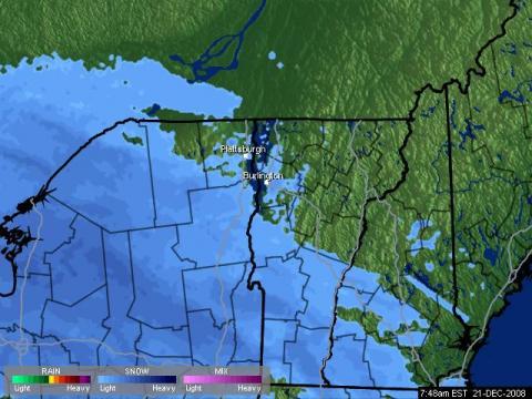
-
Tempête possible les 21 et 22 décembre
iceberg a répondu à un(e) topic de Mistral21 dans Discussions générales
How much inches of snow would it mean for Montreal ? Combien de pouces de neige ça voudrait dire pour Montreal ? Im still sticking with 30 cms the reason with this is that once the coastal system tracks near the Bay of Fundy. There will be a return of moisture running along the St. Lawrence from the system and that will give us a 10cm on top of the 20cm from sunday. -
Conférence sur les changements climatiques en Pol.
iceberg a répondu à a topic dans Discussions générales
More global warming !!! over 1500 records broken !!! http://iceagenow.com/Record_Lows_2008.htm -
Conférence sur les changements climatiques en Pol.
iceberg a répondu à a topic dans Discussions générales
Where is global warming ???? Severe Cold Wave to Hit Europe By Joe Bastardi, Senior Meterologist at accuweather.com ______________________________ 19 Dec 08 (Excerpts) The development of a major blocking high pressure system over the north Atlantic and its subsequent backing west is about to throw most of Europe into the coldest winter weather pattern in many a year Temps over the next month or so are liable to average 6-10 degrees F below normal over the center part of the continentIntuitive with this is the likelihood of more than normal snow and ice I wish to point out, with no malice intended, that the two countries with major scientific organizations pushing the global warming idea, Britain and the UKMET and the US with NOAA have been burned by the cold that has developed here. NOAA had a December forecast for a warm central US for November that they were forced to revise and the UKMET forecast for a rather bland winter for Europe speaks for itself. Its anything but bland. If an enemy is vanquished, it should not be able to launch attacks of this magnitude. See entire article: http://www.accuweather.com/ukie/bastardi-e...ner=accuweather