iceberg
-
Compteur de contenus
1 349 -
Inscription
-
Dernière visite
-
Jours gagnés
47
Type de contenu
Profils
Forums
Events
Gallery
Tout ce qui a été posté par iceberg
-
Observations 15 juin au 21 juin
iceberg a répondu à un(e) topic de shawn_strat dans Discussions générales
current - courant - observation : 17:32PM EST place: Montreal-East obs: Thunderstorm with rain temp: 17.0c dew: 12.8c wchill: 17.0c hum: 76% wind: 1.1km/h SSW gust: 3.6km/h pres: 1016.6 hpa ® rain: 3.0mm since 15:00pm weather notes : A drop of 8 degrees in 30 min since 16:45pm with a reading of 24.9c -
Observations 8 juin au 14 juin
iceberg a répondu à un(e) topic de shawn_strat dans Discussions générales
current - courant - observation : 05:35am est place: Montreal-East obs: Cloudy temp: 16.2C dew: 10.5C wchill: 16.2C hum: 69% wind: 3.6km/h NE gust: 7.2km/h pres: 1015.1 hpa ® rain: NIL since 24:00AM -
Observations 8 juin au 14 juin
iceberg a répondu à un(e) topic de shawn_strat dans Discussions générales
current - courant - observation : 23:36pm est place: Montreal-East obs: Partly Cloudy temp: 19.5C dew: 10.2C wchill: 19.5C hum: 55% wind: 6.1km/h NW gust: 12.2km/h pres: 1013.0 hpa ® rain: NIL since 24:00AM -
Observations 8 juin au 14 juin
iceberg a répondu à un(e) topic de shawn_strat dans Discussions générales
current - courant - observation : 23:26pm est place: Montreal-East obs: Partly Cloudy temp: 21.0C dew: 12.5C hum : 58% wind : 1.1km/h W gust : 3.6km/h pres : 1010.9 hpa ® rain : 8.1mm since 24:00AM -
Observations 8 juin au 14 juin
iceberg a répondu à un(e) topic de shawn_strat dans Discussions générales
current - courant - observation : 23:35pm est place: Montreal-East obs: Cloudy temp: 20.5C dew: 16.2C hum : 76% wind : 3.6km/h SE gust : 6.1km/h pres : 1008.1 hpa (F) rain : Nil since 24:00AM Weather notes : Winds were very calm during the night hours,2.5km/h at 00:48am then remained calm till 5:18am when a wind measured at 2.5km/h from the north. -
Observations 8 juin au 14 juin
iceberg a répondu à un(e) topic de shawn_strat dans Discussions générales
current - courant - observation : 22:06pm est June 10, 2009. place: montreal-east obs: partly cloudy temp: 17.0C hum : 68% wind : 1.1km/h NW pres : 1014.2 hpa rain : nil since 19:00pm -
Observations 8 juin au 14 juin
iceberg a répondu à un(e) topic de shawn_strat dans Discussions générales
current - courant - observation : 22:40pm est place: montreal-east obs: cloudy temp: 12.2C hum : 87% wind : 1.1km/h NW pres : 1011.0 hpa rain : 0.3mm since 19:00pm -
May 10th 1963 Montreal Dorval... link lien: http://www.climate.weatheroffice.ec.gc.ca/...&Month=5&Day=10
-
Maxime tell me why snow in the month of May is not normal in the province of Quebec and Montreal. If i look at the past records it has snowed many times in May in Montreal and as for the year without a summer in 1816 yes it was a volcano that disturbed the climate worldwide but there are other years where it snowed in June in Montreal dating back to 1604.
-
It has already snowed in June in Montreal so its no surprise to have snow in May !! The year 1816 the year without a summer was one of them. Montreal had 1 inch on June 6 and 2 inches on June 8. Quebec City had 12 inches from June 6th to June 10th. Also of note both July and August had much frost and snow flakes both in Montreal and Quebec City.
-
Un stade gonflable s'écrase au Texas.
iceberg a répondu à un(e) topic de Regg001 dans Discussions générales
WOW !!! TOO BAD THE COWBOYS ARE NOT MY FAVORITE TEAM !!! -
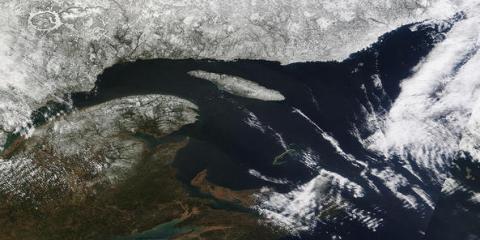
Gaspe Peninsula and far northeastern Quebec. D'Anticosti Island (upper center) is still covered with snow and ice. The brighter white areas on the right side are clouds. Picture and words are from Brett Anderson Accuweather.
-
First images of lightning from a volcano. Here is the link lien : http://www.livescience.com/environment/090...-lightning.html
-
L'influence de notre climat sur celui de l'europe
iceberg a répondu à un(e) topic de Caro_richard dans Discussions générales
Hello Caroline Here is a link where it could help you explain more for the question you put foward about the weather here in Quebec and if it could effect France.Ive seen some answers like the balloon effect which i think is full of hot air so that answer is out of the question. Franck and David have put the best answers to your question. LINK LIEN : http://www.windows.ucar.edu/tour/link=/ear...s.html&edu=high -
Temp of 12.5c raw and windy.Good cells apperaing on the radar west of montreal. RADAR: http://radar.weather.gov/radar.php?rid=cxx...101111&loop=yes
-
L'influence de notre climat sur celui de l'europe
iceberg a répondu à un(e) topic de Caro_richard dans Discussions générales
Hello Carro I know for a fact that in summer time that if Southern Europe is having a heat wave, we have here in Southern Quebec a wet cool summer and vice versa most of the times. Here is a link or lien of what i mean and look carefully at the highs and lows pressure systems. http://www.opc.ncep.noaa.gov/UA.shtml -
New record set for march snowfall for PIERRE ELLIOTT TRUDEAU airport. New mark is 2.6cm 2009 and old record 3.3cm set in 1946.
-
I think we have to view this event much more serious then other weather events. The years 1989 and 1859. The year 1989 it hit Quebec and 9 million people were without power for 9 hours. The year 1859 the carrington event which hit in a global scale. It could also affect our worlds climate system. here is the link : voici le lien : http://www.newscientist.com/article/mg2012....html?full=true
-
DISCUSSIONS ÉVÉNEMENTS du 23 au 29 mars 2009
iceberg a répondu à un(e) topic de Trapper dans Discussions générales
HERE ARE THE WARNINGS AND WATCHES FOR THE U.S.A. ALSO YOU CAN VIEW REPORTS AS THEY COME LIVE ! http://www.spc.noaa.gov/products/wwa/ http://www.spc.noaa.gov/ -
WELL IT COULD BE THAT SOMEONE IS OUT TO GET JAMES HANSEN HEAD. IT DOES NOT BOLD WELL FOR HANSEN AFTER THIS CRASH FAILURE !! THIS IS THE LINK: http://co2sceptics.com/news.php?id=2862
-
Les Outbreaks tardent au U.S.A
iceberg a répondu à un(e) topic de stefano dans Discussions générales
Bonjour Stefano, It's a matter of weather patterns and how they establish themselves. Some years are active, some are not. It is just the natural variability of weather in the Southeast or tornado alley. We have had several situations in which the atmospheric conditions were just right to produce strong storms with tornadoes. Atmospheric conditions that produce tornadoes are essentially the same everywhere because the laws of physics apply universally. There are differences in how the essential ingredients to produce a tornado might come together in Georgia versus the Southern Plains, but the ingredients are the same. Because those ingredients are slightly more common in tornado alley, they get more tornadoes. While higher temperatures could increase the number of thunderstorms, which are needed to trigger tornadoes, they also would tend to push the storm systems too far north to form some twisters. La Nina, the cooling of parts of the Central Pacific that is the flip side El Nino, was a factor in the increased activity in 2008 - especially in February, a record month for tornado activity - but it can't explain what is happening now. Some years are active and some not and not even weather experts dont know why !! -
Thats right folks noaa lost all that ice and the truth is coming out also on how much cooler the earth will get and that news will come out next week in a report noaa will make and why it made these silly forcasts based on incorrect satalite data and faulty model information. voici le lien: http://iceagenow.com/We_overlooked_193000_...iles_of_ice.htm
-
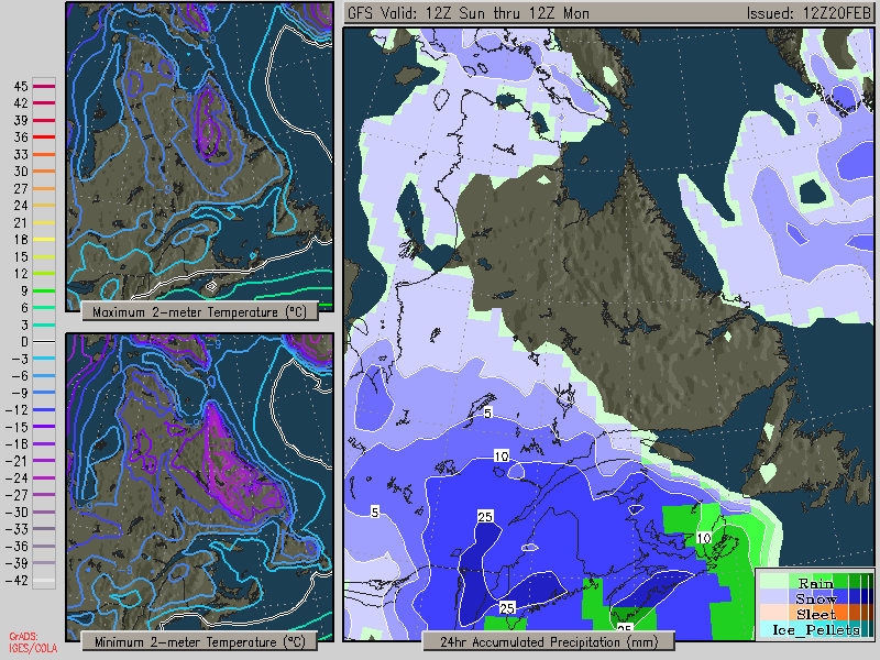
DISCUSSIONS ÉVÉNEMENTS du 23 fév. au 1 mars 2009
iceberg a répondu à un(e) topic de Trapper dans Discussions générales
Quite possible Montreal could recive between 15cm to 20cm depends how far west secondary storm will develop.
-
I think this will lead to more snowstorms for Southern Quebec as the polar jet stream will wobble between the Canadian and USA border while the pacific jet will sometimes collide with the polar jet. Temps will be normal to just below normal for March and April.
-
VOICI LE LIEN POUR LE MISE A JOUR POUR EL NINO / LA NINA. LA NINA VA ETRE LA POUR LE PRINTEMPS. http://www.cpc.ncep.noaa.gov/products/anal...e/sstanim.shtml