iceberg
-
Compteur de contenus
1 349 -
Inscription
-
Dernière visite
-
Jours gagnés
47
Type de contenu
Profils
Forums
Events
Gallery
Tout ce qui a été posté par iceberg
-
Observations des 27 et 28 décembre
iceberg a répondu à un(e) topic de Tornade dans Discussions générales
North East observations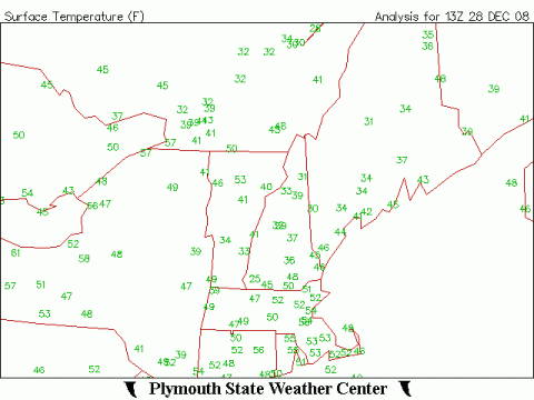
-
DISCUSSIONS ÉVÉNEMENTS du 29 déc 08 au 4 jan 09
iceberg a répondu à un(e) topic de Trapper dans Discussions générales
POTENTIAL SNOW STORM FOR JAN 4TH FOR SOUTHERN QUEBEC.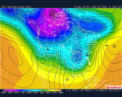
-
Observations des 27 et 28 décembre
iceberg a répondu à un(e) topic de Tornade dans Discussions générales
NORTH EAST OBSERVATIONS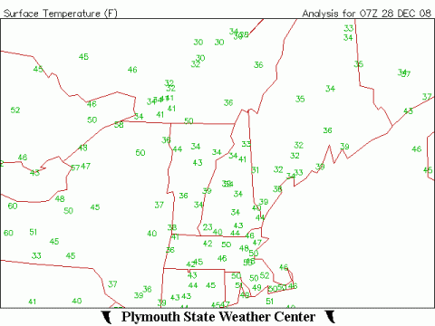
-
Observations des 27 et 28 décembre
iceberg a répondu à un(e) topic de Tornade dans Discussions générales
erol coudonc il fait 22.6c chez nous a montreal-est !!! -
Observations des 27 et 28 décembre
iceberg a répondu à un(e) topic de Tornade dans Discussions générales
Like i said in my early winter forcast this winter will resemble 2002 and its right on target with lots of ups and downs temps wize. http://www.climate.weatheroffice.ec.gc.ca/...&Month=12&Day=1 -
Observations des 27 et 28 décembre
iceberg a répondu à un(e) topic de Tornade dans Discussions générales
This has happened before shawn so its not out of the ordinary.The 1890s 1920s mid 1940s and early 1950s. -
A HIGH WIND WATCH MEANS THERE IS THE POTENTIAL FOR A HAZARDOUS HIGH WIND EVENT. SUSTAINED WINDS OF AT LEAST 40 MPH...OR GUSTS OF 58 MPH OR STRONGER MAY OCCUR. And this is for the Montreal area too for sunday evening. A sharp cold front will invade Southern Quebec.
-
Observations des 27 et 28 décembre
iceberg a répondu à un(e) topic de Tornade dans Discussions générales
Montreal -est faible pluie 0.7c 5:13pm Montreal-east light rain 0.7c 5:13pm radar: http://www.intellicast.com/National/Radar/...cation=USVT0147 -
Observations des 27 et 28 décembre
iceberg a répondu à un(e) topic de Tornade dans Discussions générales
Montreal -est nuageux -5.2c 9:02am Montreal-east cloudy -5.2c 9:02am radar: http://www.intellicast.com/National/Radar/...cation=USVT0147 -
Observations des 27 et 28 décembre
iceberg a répondu à un(e) topic de Tornade dans Discussions générales
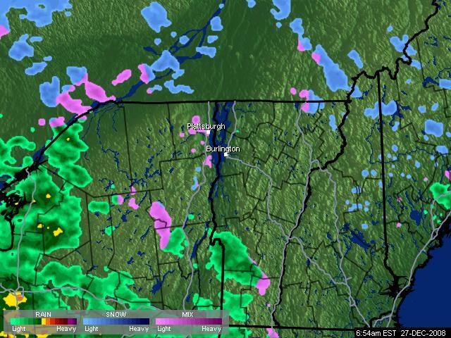
Ice, cet image radar n'est pas assez précise. Elle indiquait à 06:54 de la neige alors que c'était de la pluie ici (verglaçante). Aussi, elle semble laisser plein de trous où il n'y aurait pas de précipitation alors que ça tombe en continue. THANKS REGG ill try another one from intellicast. -
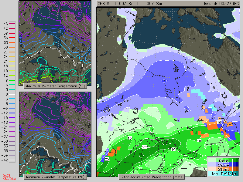
This is the 24 hour accumalation graph and you see where all the moisture is being pumped by the low pressure system which is a north east direction heading to Hudson Bay.Blizzard warnings are out already for Kuujjuarpik, Umiujaq and the Sanikiluaq Islands.
-
Observations des 27 et 28 décembre
iceberg a répondu à un(e) topic de Tornade dans Discussions générales
montreal-est nuaguex -5.8c 7:09am montreal-east cloudy -5.8c 7:09am radar: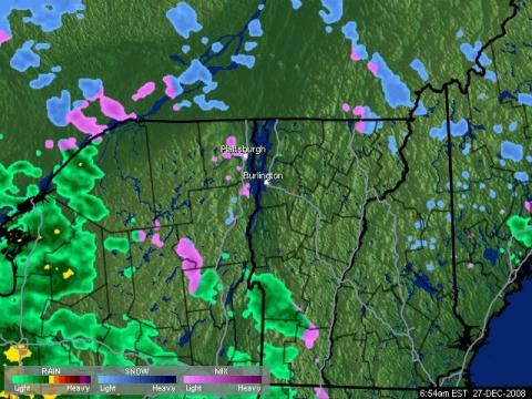
-
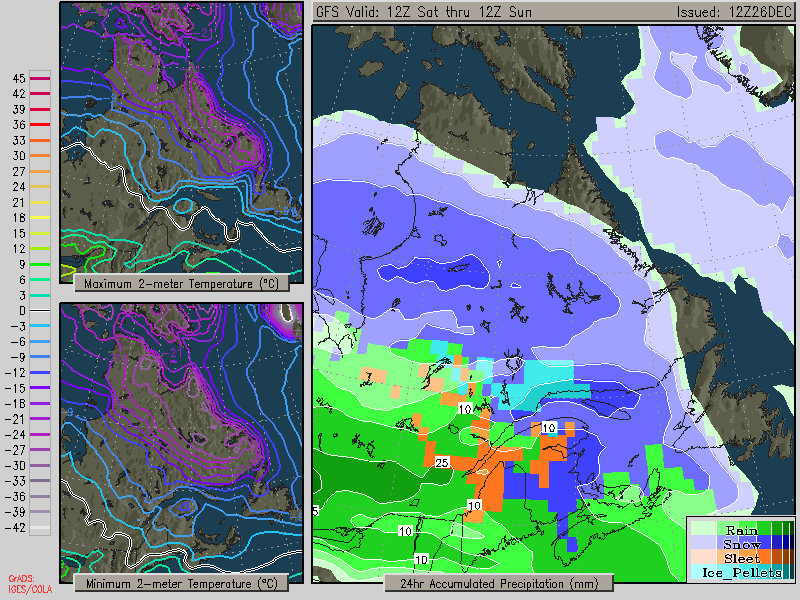
24 hr precip accumalation. You could see that low pressure systems energy (moisture) is all being pushed well north of Montreal.
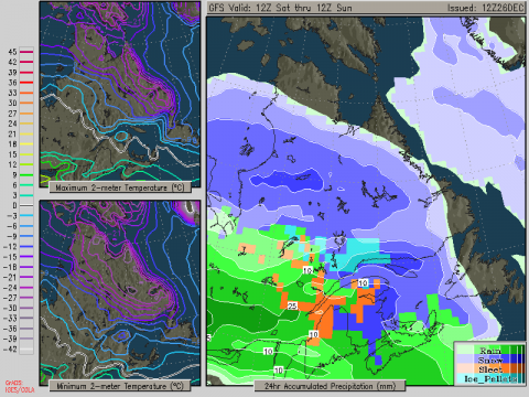
-
Observations système 24-25et 26 décembre 2008
iceberg a répondu à un(e) topic de Trapper dans Discussions générales
HELLO SHAWN If possible could you update me at 2:30 and 3 pm and give me your temp at RDP. I set up a another one this time with a wire and ill also check the wireless one if its at the same temp as the other one. . Thanks Shawn_strat et Iceberg, Voici les conditions météo à Ville St-Laurent : Date et heure : 12/26/08 3:00p (Heure locale) Température (10 m) : -10.1°C Température (1.5 m) : -10.6°C Point de rosée : -12.7°C Refroidissement éolien : -12.9°C Humidité : 81% Pression atmosphérique et tendance : 1033.4 mb - Falling Slowly Vitesse du vent (10 min) et direction : 4.8 km/h de secteur N (355°) Rayonnement solaire : 69 W/m2 Iceberg : tu te trouves ou exactement à Montréal ? Si vous avez besoin des données supplémentaires, vous pouvez aller consulter mon Feed RSS. Mise à jour toutes les 10 minutes. Bon étalonnage. ENTRE ST. LEONARD ET ANJOU.A LA LIMITE DE ST.LEONARD. -
Observations système 24-25et 26 décembre 2008
iceberg a répondu à un(e) topic de Trapper dans Discussions générales
hello shawn and celini montreal-est nuageux -9.2c 3:43pm monteal-east cloudy -9.2c 3:43pm my wireless says -7.3c a diff of 2c thanks for the info guys -
Observations système 24-25et 26 décembre 2008
iceberg a répondu à un(e) topic de Trapper dans Discussions générales
HELLO SHAWN If possible could you update me at 2:30 and 3 pm and give me your temp at RDP. I set up a another one this time with a wire and ill also check the wireless one if its at the same temp as the other one. . Thanks -
Observations système 24-25et 26 décembre 2008
iceberg a répondu à un(e) topic de Trapper dans Discussions générales
18.0° le 6 décembre 2001, record mensuel. Merci Tyrone tu a raison. -
Observations système 24-25et 26 décembre 2008
iceberg a répondu à un(e) topic de Trapper dans Discussions générales
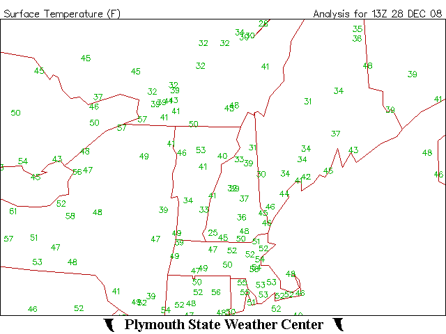
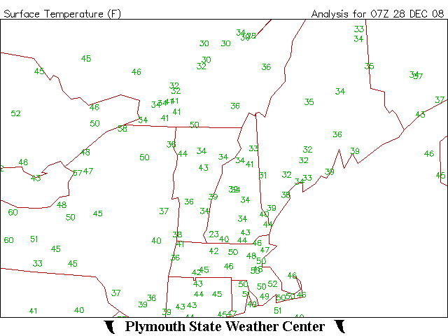
New record might be broken for the Montreal area for maximum temp for Dec.27 2008. The record to beat is 10.6c set in 1895. The maximum record for a December month is 18.0c set in Dec. 6 2001. Oddly enough this record that stood for 113 years might have the same track that the low pressure system is taking now, because Toronto Ontario also had a reading of 10.6c on dec 25th and 8.9c on dec 26th 1895, as system tracked north north east winds from the south south west push warm humid air from the gulf of Mexico into Southern Ontario and Southern Quebec making for the temp records back then.What im doing now is some detective work i might be wrong but im taking a guess. -
Observations système 24-25et 26 décembre 2008
iceberg a répondu à un(e) topic de Trapper dans Discussions générales
Montreal-est Généralement nuageux -6.8c 12:35pm Montreal-east mostly cloudy -6.8c 12:35pm Aéroport intl de Montréal-Trudeau nuageux -11.2c 12:38pm diff= 4.4c ouest a est -
Observations système 24-25et 26 décembre 2008
iceberg a répondu à un(e) topic de Trapper dans Discussions générales
QUOTE (colapster89 @ December 25, 2008 04:18 pm) depuis aussi longtemps qu'on prend des relevés météo, un hiver sans pluie ou redoux sa n'existe pas au Québec. Here are some numbers for you Colapster for Montreal winters with least amount of rain.. the winter season of 1955-56 is the winner so far with 23.5mm DEC TO FEB 1874-75 = 8.4MM 1962-63 = 8.7MM JAN TO FEB 1868= TRACE 1987= TRACE 1879= 0.8MM 1977= 4.8MM JAN TO MARCH 1856= 0.0MM 1940= 5.4MM DEC TO MARCH 1955-56 = 23.5MM -
Rafales de vent a Toronto a 93km/h derniere heure.

-
Observations système 24-25et 26 décembre 2008
iceberg a répondu à un(e) topic de Trapper dans Discussions générales
montreal-est Faible pluie verglaçante 0.6c 7:57pm montreal-east light freezing rain 0.6c 7:57pm radar: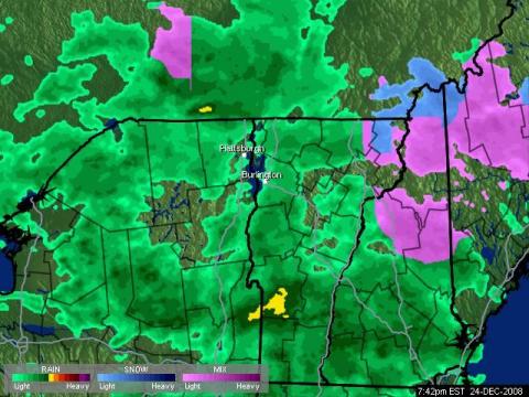
-
Observations système 24-25et 26 décembre 2008
iceberg a répondu à un(e) topic de Trapper dans Discussions générales
Montreal-est Faible bruine verglaçante -0.1c 6:04pm Montreal-east light freezing drizzle -0.1c 6:04pm radar:
-
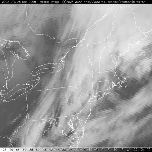
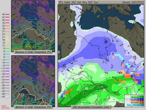
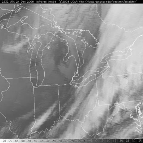
Cold front is just passing by the Winsdor Sarnia corridor the past few hours, winds have picked WSW and i would say by 1:00am temp will start to fall in the Montreal area. IN THIS IMAGE YOU COULD SEE THE SHARP COLD FRONT MOVING BY THE AREAS I MENTIONED ABOVE.
-
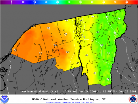
Pas mal de vent pour cette nuit. Ca va brasser pour le sud de Quebec. HIGH WIND WARNING IN EFFECT FROM 10 PM THIS EVENING TO 12 PM EST THURSDAY... THE NATIONAL WEATHER SERVICE IN BURLINGTON HAS ISSUED A HIGH WIND WARNING...WHICH IS IN EFFECT FROM 10 PM THIS EVENING TO 12 PM EST THURSDAY...FOR WIND GUSTS TO 60 MPH...ACROSS THE NORTHERN ADIRONDACK MOUNTAINS AND SAINT LAWRENCE RIVER VALLEY IN NORTHERN NEW YORK.