iceberg
-
Compteur de contenus
1 349 -
Inscription
-
Dernière visite
-
Jours gagnés
47
Type de contenu
Profils
Forums
Events
Gallery
Tout ce qui a été posté par iceberg
-
Rechauffement Climatique Global Warming
iceberg a répondu à un(e) topic de iceberg dans Discussions générales
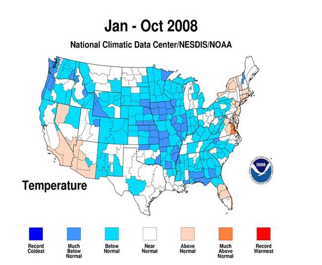
October was a cold month in many areas of the east and central states. For the nation as a whole, the average October temperature of 54.5 degrees F was 0.3 degree F below the 20th Century average, based on preliminary data.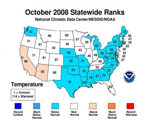
-
Rechauffement Climatique Global Warming
iceberg a répondu à un(e) topic de iceberg dans Discussions générales
NOAA shows the first ten months of the year were cold over many areas of the country from the Northwest to the Central States. Above normal temperatures were confined to sections of the east and southwest.
-
Un dur hiver à venir ? hard winter to come ?
iceberg a répondu à un(e) topic de iceberg dans Discussions générales
As i forcasted in August EL NINO will not form this winter as some readers say it will. I expect a very cold start to the winter season then return to normal in January and back to very cold in Feburary and March. As for precip for the winter season expect normal to above normal snowfall . -
Un dur hiver à venir ? hard winter to come ?
iceberg a répondu à un(e) topic de iceberg dans Discussions générales
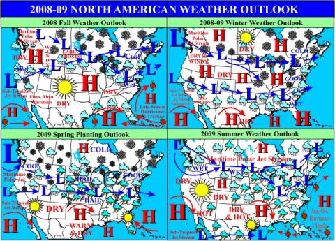
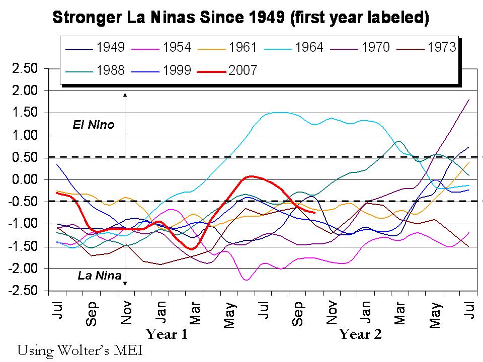
Nov 07, 2008 Another Cold December to March for Many Locations By Joseph DAleo, CCM, AMS Fellow La Nina is gradually returning. The Multivariate ENSO Index (MEI) has dropped to -0.74 in October, well into weak La Nina territory. The tropical Pacific sea surface temperatures all the way from South America to beyond the dateline are back below normal. The North Pacific as a whole remains strongly in the cold mode (negative PDO). The Atlantic is weakly in its warm mode (Atlantic Multidecadal Oscillation is positive). The sun recently showing slight signs of life is still at solar minimum levels. The winds in the stratosphere over the tropical Pacific are blowing anomalously westerly) in their Quasi Biennial Oscillation. All these conditions point to another cold winter in all but the southeastern United States, most of central and western Canada, most of western Europe, eastern and southern Asia. Expect a coolish summer in South Africa, Indonesia and South America and parts of New Zealand and Australia. We are already seeing early cold and snow in the northern Rockies and Plains and even in the UK. Cold weather appears to be in the cards for eastern Asia the next week or two. Blocking high pressure seen above in first figure in the North Atlantic is what will keep northwest Europe and the eastern United States cold. Snow should be heaviest relative to normal from the northern and central Rockies, northern and central Plains, Ohio Valley to the Mid-Atlantic and southeastern New England. Snow to north should be less than last year but snowcover will be most persistent there. WHAT TO WATCH FOR: Should La Nina become stronger than expected, the southeast warmth will be more pervasive and extend further north and west the second half of winter. That is the classic pattern in west QBO La Ninas. However, most strong La Ninas as was the case last winter reprise in a weakened form the second winter especially if they weakened as much a this one did during the intervening summer. The maps about are based on that assumption.
-
diff from last years ice pack here is the link .... http://igloo.atmos.uiuc.edu/cgi-bin/test/p...1&sd=07&sy=2008
-
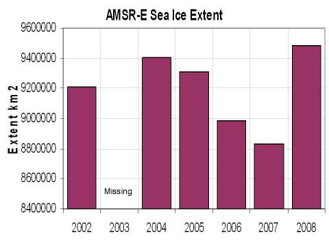
Nov 08, 2008 Arctic Ice Extent Now Likely Highest Level Since 2002 By Joseph DAleo The latest daily arctic sea ice extent chart from IJIS shows the current year ice extent at the highest level in the record back to 2002. (2003 was missing). The daily extents on November 7 look like this: This represents an increase of 655,781 square kilometers over last November 7 or 7.4%. Side-by-side images from the Cryosphere show there is more ice on both the Pacific and Atlantic side this year. This is 44 days before the start of the Northern Hemisphere winter and 5 months before it will peak.
-
Rechauffement Climatique Global Warming
iceberg a répondu à un(e) topic de iceberg dans Discussions générales
Well i hope global warming has stopped, could this be just the begining of a small ice age to set in the decades to come ??? -
Rechauffement Climatique Global Warming
iceberg a répondu à un(e) topic de iceberg dans Discussions générales
I really wish that the earths temp will begin to fall and it really has good chances but we still have to cut down on co2 levels for health reasons also and try to have a green earth. Im all for it but when some people that come along and start bashing other peoples opinion and not give them a chance i really think you are anti green.Lets see in the next five years where the temp graph brings us and then you could start to talk loud with the oil starved companys, and dont get me wrong id rather have all out anti - pollution law in affect as of right now. -
Prévision hiver 2008-2009
iceberg a répondu à un(e) topic de A.Theunissen dans Discussions générales
PAS DE EL NINO CETTE HIVER !!!! Temps will still be in normal mode in the pacific basin by November and below normal by january. Winters of this calibre bring extreme temp swings for southern Quebec. If i would take a guess this winter it would be like the winter of 2002-03 for temps only and for precip normal to above normal towards the end of winter. -
Rechauffement Climatique Global Warming
iceberg a répondu à un(e) topic de iceberg dans Discussions générales
Global warming is it yes or no ??? Now my view on global warming is what i think what many people want you to believe, the general population that is politics are involved in this of course and information from the internet from various sources.What i think is happening on this climate change is a cycle that has been on this planet for millions of years and is going about its course. Now add some co2 to it the atmosphere, add some human life of about 6 billion people, cut some trees about one 3rd from the amazon and yes of course you will alter the cycle BUT to what extent is the question. They say the north pole was tropical, came back to its state which is today and now is it going back to its former state which was tropical? The answer to that is WE DO NOT KNOW. Time will tell but maybe not in our generation and maybe not the next,but what we really have to focus on is how will human life adapt to this change which is occuring in front of our eyes, but its all normal because it has happened before. So to put this in a short pharse global warming does not exist, but climate change does exist.Will the earth cool down in the next 100 years or warm up or just be normal, well this is up to us on how we will handle this, the human population on this planet. -
Rechauffement Climatique Global Warming
iceberg a répondu à un(e) topic de iceberg dans Discussions générales
FREEDOM OF SPEECH !! I think this is a wonderful weather forum where you are allowed to post some information or photos. Now i understand there are some members or visitiors in this forum that dont agree what i post and some members or visitors that agree what i post. When i post some news or information it does not mean that i agree with what it says. So if you have something against the authors in the posts i made just email them and place your anger with them but not with me.I think this is the best hobby in the world THE WEATHER its never boring and it always changes. So i think respect the other persons opinion and you dont have to agree with them but let some people have FREEDOM OF SPEECH !! MERCI THANKS -
Rechauffement Climatique Global Warming
iceberg a répondu à un(e) topic de iceberg dans Discussions générales
Pacific Decadal Oscillations Closely Tied to ENSO By Joe D'Aleo Monday, October 20, 2008 Here is the link : http://www.intellicast.com/Community/Conte...x?ref=rss&a=151 -
Rechauffement Climatique Global Warming
iceberg a répondu à un(e) topic de iceberg dans Discussions générales
I posted a article on October 19, 2008 10:32 pm on this subject . Now if you add 20 years to 1998 of course we get to the year 2018 so i think we would have a clear window if really temps are rising and one more important factor ocean temps are the key to global warming. Here is another link on this matter and talks about cities in France. http://icecap.us/images/uploads/URBAN_HEAT_ISLAND.pdf -
Rechauffement Climatique Global Warming
iceberg a répondu à un(e) topic de iceberg dans Discussions générales
Bonjour cpweather To answer your question i think micro climate has to do more to the rising temps. In suburb areas temps actually are going down but in large cities they are going up. And remember one other fact the only year where we broke temps was in 1998 and that year was not even close to breaking all time records set in 1934 now if you compare large cities in France to small ones look to see how many records were broken from 1998 to 2005 and i would bet the small cities would have very few.Im not saying that you are wrong but in the next 10 years we will have a better idea of where the global temps are going. -
Rechauffement Climatique Global Warming
iceberg a répondu à un(e) topic de iceberg dans Discussions générales
La peur d'avoir peur Dans La presse montreal dimanche 19 octobre 2008... A very good article on the rechauffement climatique by Bjorn Lomborg and Jean Lemire. Ive read the article and it makes you think.. -
DISCUSSIONS ÉVÉNEMENTS du 27 oct au 2 nov 2008
iceberg a répondu à un(e) topic de Trapper dans Discussions générales
Colder then normal temps, any low pressure systems that ride along the jet stream i think we would see solid precip. This would be caused by high pressure anchored off greenland.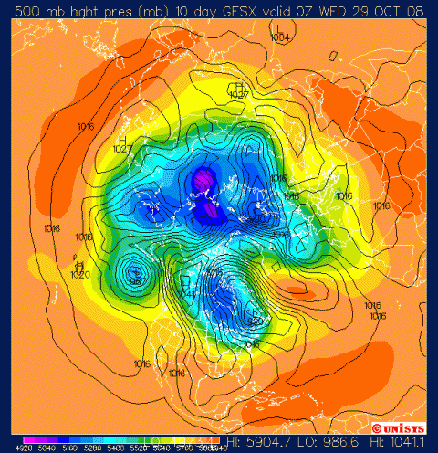
-
DISCUSSIONS ÉVÉNEMENTS du 27 oct au 2 nov 2008
iceberg a répondu à un(e) topic de Trapper dans Discussions générales
Day 10 outlook. I think this large upper air trough will park its self the first few weeks of November, Something to watch for !!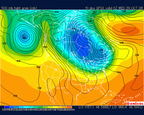
-
DISCUSSIONS ÉVÉNEMENTS du 27 oct au 2 nov 2008
iceberg a répondu à un(e) topic de Trapper dans Discussions générales
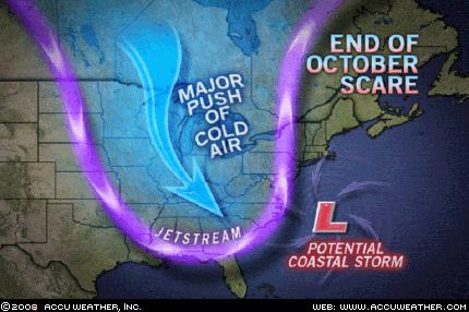
Watch for a dramatic change in the weather seven to ten days from now. During the 27th and 28th a large upper air trough will form over the eastern half of the nation. This will bring the coldest weather so far this season to the Midwest and East. In addition, just before the cold takes over, there is also a chance that a big storm will come up the Eastern Seaboard. This is one of those 50-50 deals right now, but I thought it was worth mentioning. Story by AccuWeather.com Senior Meteorologist John Kocet.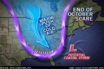
-
yes indeed they have shawn and here is the storyline on this event.... The recent enhanced warm season melting of the arctic ice has precious little to do with greenhouse gases but is a cyclical phenomena related to multidecadal cycles in both the Atlantic and the Pacific. The Atlantic appears to be the most important. The Atlantic has been in its warm mode since 1995 with a peak around 2004 and 2005. Warm water from the Atlantic makes its way into the arctic through the Barents Sea and the Pacific through the Bering Strait. Last year before the alarmists took control, the University of Colorados National Snow and Ice Data Center (NSIDC) summarized the role of the ocean cycles very well in October 2007 in this way: One prominent researcher, Igor Polyakov at the University of Fairbanks, Alaska, points out that pulses of unusually warm water have been entering the Arctic Ocean from the Atlantic, which several years later are seen in the ocean north of Siberia. These pulses of water are helping to heat the upper Arctic Ocean, contributing to summer ice melt and helping to reduce winter ice growth. Another scientist, Koji Shimada of the Japan Agency for Marine�Earth Science and Technology, reports evidence of changes in ocean circulation in the Pacific side of the Arctic Ocean. Through a complex interaction with declining sea ice, warm water entering the Arctic Ocean through Bering Strait in summer is being shunted from the Alaskan coast into the Arctic Ocean, where it fosters further ice loss. Many questions still remain to be answered, but these changes in ocean circulation may be important keys for understanding the observed loss of Arctic sea ice.
-
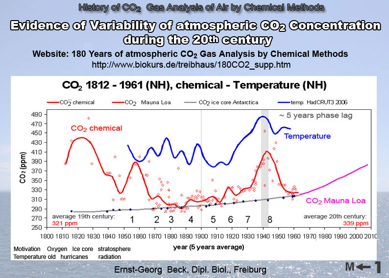
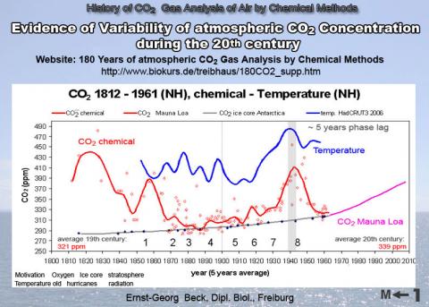
Complementary to measurements in Antarctic ice cores, stomatal frequency analysis of leaves of land plants preserved in peat and lake deposits can provide a proxy record of preindustrial atmospheric CO2 concentration. CO2 trends based on leaf remains of /Quercus robur/(English oak) from the Netherlands support the presence of significant CO2 variability during the first half of the last millennium. The amplitude of the reconstructed multidecadal fluctuations, up to 34 parts per million by volume, considerably exceeds maximum shifts measured in Antarctic ice. Inferred changes in CO2 radiative forcing are of a magnitude similar to variations ascribed to other mechanisms, particularly solar irradiance and volcanic activity, and may therefore call into question the concept of the Intergovernmental Panel on Climate Change, which assumes an insignificant role of CO2 as a preindustrial climate-forcing factor. The stomata-based CO2 trends correlate with coeval sea-surface temperature trends in the North Atlantic Ocean, suggesting the possibility of an oceanic source/sink mechanism for the recorded CO2 changes. New findings indicate a natural climate cycle occurring approximately every 65 years (50-80 y). Modern state of the oceans is similar to the oceans during the 30s in the 20th century. During the strong arctic warming since 1918 the oceanic currents had brought warmer water to the CO2 absorption areas near Greenland-Iceland-Spitsbergen than at the end of the 19th century. High salinity, pH and other characteristics inclusive a spread of phytoplankton had been measured during this warm period in the northern Atlantic ocean as we see today with its special 13C signature. These ocean currents were responsible for warmer climates in the northern continents at that times and colder climates in their cold phases (around 1900 and 1965). The strong heating of the CO2 absorption areas, which occurs in a multi-decadal cycle (approx. 1780, 1850, 1935, 2000, evidence for the last two cycles) prevents a stronger CO2 absorption by the arctic oceans and thereby enriches the atmosphere with more CO2 than in the colder phase of the cycle. These cold and warm phases of the ocean current cycle correlates with a cycling of the geomagnetic index (SSC) and solar activities (Gleissberg cycle), a function of the chaotic, non-linear solar dynamo.
-
The recent enhanced warm season melting of the arctic ice has precious little to do with greenhouse gases but is a cyclical phenomena related to multidecadal cycles in both the Atlantic and the Pacific. The Atlantic appears to be the most important. The Atlantic has been in its warm mode since 1995 with a peak around 2004 and 2005. Warm water from the Atlantic makes its way into the arctic through the Barents Sea and the Pacific through the Bering Strait. Last year before the alarmists took control, the University of Colorados National Snow and Ice Data Center (NSIDC) summarized the role of the ocean cycles very well in October 2007 in this way: One prominent researcher, Igor Polyakov at the University of Fairbanks, Alaska, points out that pulses of unusually warm water have been entering the Arctic Ocean from the Atlantic, which several years later are seen in the ocean north of Siberia. These pulses of water are helping to heat the upper Arctic Ocean, contributing to summer ice melt and helping to reduce winter ice growth. Another scientist, Koji Shimada of the Japan Agency for Marine�Earth Science and Technology, reports evidence of changes in ocean circulation in the Pacific side of the Arctic Ocean. Through a complex interaction with declining sea ice, warm water entering the Arctic Ocean through Bering Strait in summer is being shunted from the Alaskan coast into the Arctic Ocean, where it fosters further ice loss. Many questions still remain to be answered, but these changes in ocean circulation may be important keys for understanding the observed loss of Arctic sea ice.
-
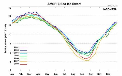
Arctic Ice Increasing Rapidly OCT 14 2008...... The arctic ice is increasing at a very rapid rate. You can see how we fell short of last years record extent and have recently been rebounding at the fastest rate of the years shown.This is very good news and i think in a about 5 to 10 years time we will see the ice back to normal as in 1980.Ive been speaking to a good friend of mine Joseph DAleo and he is amazed at the rate the ice is spreading. He works for noaa.Note Rutgers Jennifer Frances found a similar relationship between Pacific and Atlantic water temperatures. Ignore the comment in the abstract that the ocean changes are consistent with greenhouse warming as we have seen the ocean changes are cyclical and predictable and quite natural. Dr. Willie Soon also found a strong correlation with solar irradiance which may ultimately drive these ocean cycles of warming and cooling. With a cooling of the Pacific and a less warm North Atlantic and a long, deep solar minimum, the ice should continue to rebound in the next few years.
-
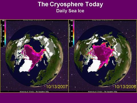
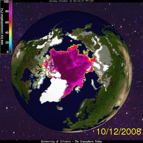
What im talking about is the north pole or arctic ocean not the south pole. Thank you for understanding. Researchers say that the recent seasonal acceleration could be in part due to conditioning going on in the Arctic. For example, research by Jennifer Kay of the National Center for Atmospheric Research in Boulder, Colo., and colleagues reported this April in Geophysical Research Letters that reduced cloud cover in 2007 allowed more sunlight to reach Earth, contributing to a measureable amount of sea ice melt at the surface. Reduced cloud cover also contributed to warmer ocean surface temperatures that led to melting of the ice from below. Here is the link to compare last years ice to this years. http://igloo.atmos.uiuc.edu/cgi-bin/test/p...0&sd=12&sy=2008
-
The ice cover in the north pole is doing very well compared to last year i would say 30 % more ice then last year at this time.As for the thicker ice its about the same.
-
Un dur hiver à venir ? hard winter to come ?
iceberg a répondu à un(e) topic de iceberg dans Discussions générales
THE NORTHEASTERN U.S. AND SOUTHEASTERN CANADA Much of November through the middle portion of December should see above normal precipitation with slightly cooler temperatures. Early snows are expected in northern New England. The first half of winter will also see colder and perhaps snowier than normal conditions across much of the northeastern U.S. and southeastern Canada. Above normal amounts of moisture should continue throughout much of the winter season. But, if El Nino "springs back to life" by the end of 2008, then temperatures will likely be warmer than normal for the second half of the winter season resulting in below normal snowfall amounts. The coldest weather of the winter season should be around the early-to-mid January timeframe. By Meteorologist Randy Mann. Washington DC