iceberg
-
Compteur de contenus
1 349 -
Inscription
-
Dernière visite
-
Jours gagnés
47
Type de contenu
Profils
Forums
Events
Gallery
Tout ce qui a été posté par iceberg
-
GOOD POINT.... ill make one LIVE FROM THE SOUTH POLE !!!! THANKS FOR THE IDEA !!!
-
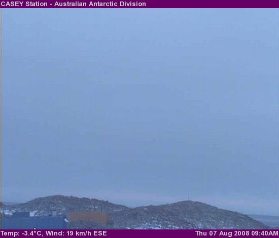
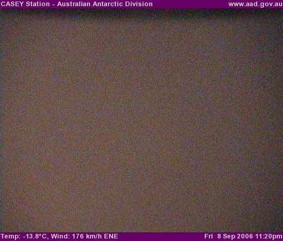
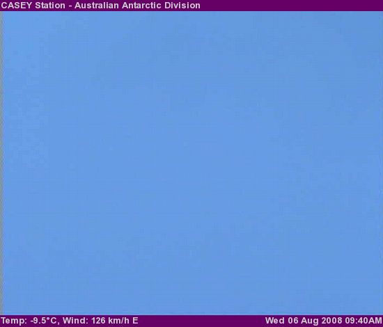
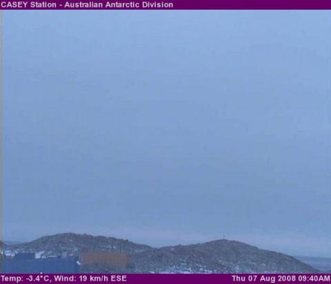
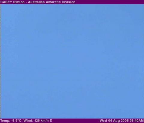
Casey station live ......
-
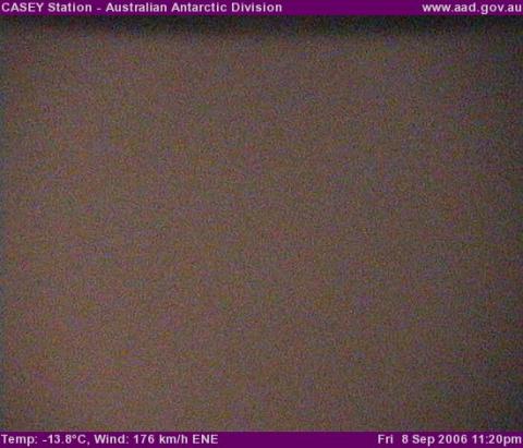
The windiest day on casey station .
-
A strong storm system gives kabatic winds on the eastern antartica region, here is what casey station registered the last 24 hours.
-
PAS DE ELNINO CETTE HIVER !!!! Temps will be in normal mode in the pacific basin by november and below normal by january. Winters of this calibre bring extreme temp swings for southern Quebec. If i would take a guess this winter would be like the winter of 2002-03.
-
ESTIMATES ARE AT 50 MM FOR MONTREAL EAST AND STILL COMING DOWN....
-
MONTREAL EAST ALERT HEAVY DOWNPOURS WATER SEWERS CANNOT TAKE THE HUGE AMOUNTS OF WATER HEAVY FLOODING IN HOMES MORE TO COME.....
-
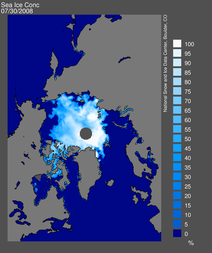
JULY 30 2008.
-
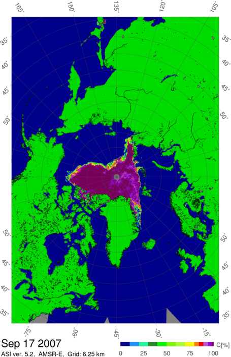
SEPT 17 2007 MINIMUM ICE

-
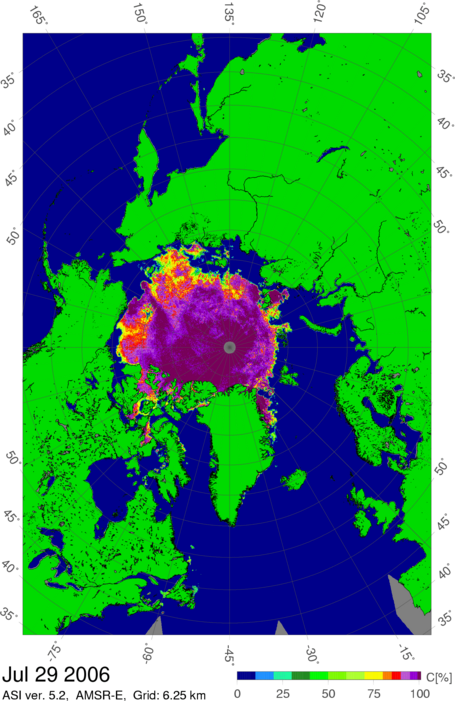
JULY 29 2006.

-
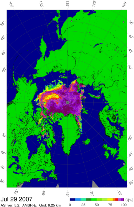
A Visual Comparison of Arctic Sea Ice

-
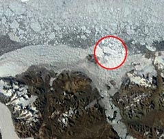
Fragmenting Arctic ice shelf a sign of warming temperatures: The fracture of a four-square-kilometre chunk of ice from the largest remaining ice shelf in the Arctic last week is a one-way change brought on by warming temperatures, says a scientist who has studied the process. Derek Mueller, a polar scientist and research fellow at Trent University, in Peterborough, Ont., said the ice breaking off from the Ward Hunt Island Ice Shelf, just north of Ellesmere Island, marks the continuation of a process that has been years in the making. "Ice shelves don't just break up. There's no karate chop," he said. "This is the result of a gradual weakening over time as a result of warming temperatures." Mueller said the changes in the shelf, which surrounds Ward Hunt Island off the north coast of Ellesmere, provide further evidence the planet, and in particular the North, is warming due to climate change. An expedition by U.S. explorer Robert Peary in 1906 put the size of the Ellesmere Island Ice Shelf at just under 9,000 square kilometres. The ice shelf has since broken up into smaller pieces, the largest of which is the Ward Hunt Island Shelf. The total area of all of these pieces is now less than 900 square kilometres. Mueller said if year-to-year warming wasn't occurring, Arctic researchers would have been able to detect some renewal of ice during the winter months, either through thickening of the ice or the spread of the shelves. But researchers haven't seen any sign of renewal, he said. "This is a one-way change," he said. Mueller was part of the team of polar researchers that first discovered in 2002 a large central crack in the ice shelf, which had occurred between 2000 and 2002. An expedition alongside Canadian Rangers on a patrol around Ellesmere Island in April 2008 found an 18-kilometre crack along the shelf, a further sign that fragmentation was likely. "Ice shelf integrity was lost in 2002," said Mueller. The 2002 fissure was blamed for the draining of an epishelf lake in Disraeli Fjord. Epishelf lakes are a unique ecosystem with both lighter freshwater and denser saltwater, with the freshwater component kept away from the ocean by the ice shelf while the bottom layer of seawater can mix with ocean water. The ecosystem is home to a unique mix of zooplankton and other tiny life forms. Mueller said the next major epishelf lake potentially under threat in the region is the Milne epishelf lake, which is bound in the Milne fjord by the Milne Ice Shelf, the second-largest remnant of the Ellesmere Island Ice Shelf. The ice island that formed last week is the largest to form off Canada's northern coast since the 2005 collapse of the Ayles Ice Shelf, which lay between the Milne and Ward Hunt Island shelves. The ice island that subsequently formed had a surface area of about 66 square kilometres.

-
MORE CHARTS

-
CHARTS
-
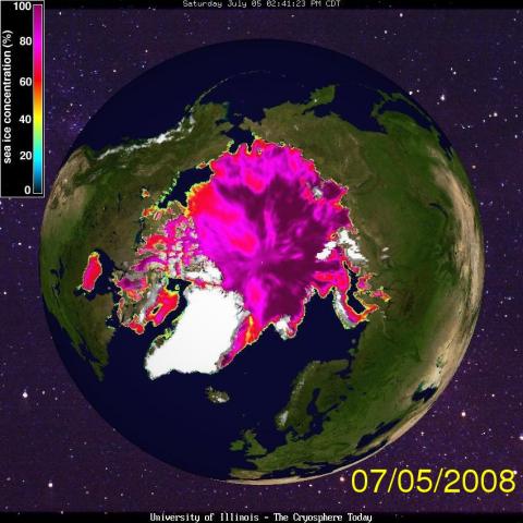
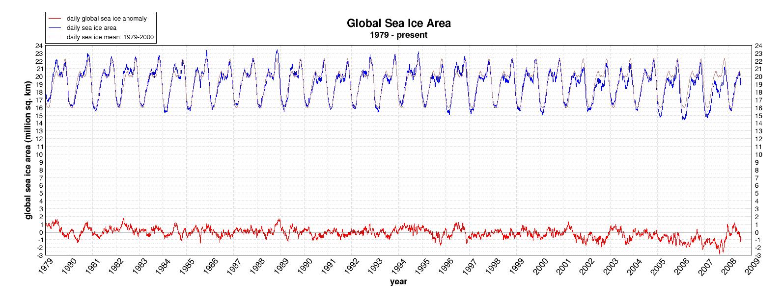
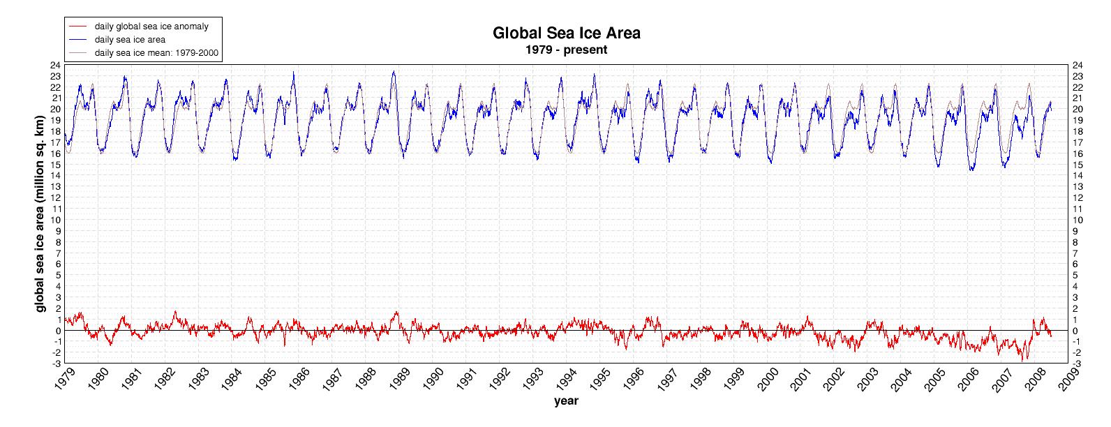
Bonjour a tous.. ice levels in the Northern Hemisphere are still 40% above as of late July 2008, compared to July 2007. The High Arctic is doing very well compared to last year . Hudson bay still has some ice left on its south shore. Now to the important facts, ice thickness is about the same, the only difference this years ice is more spread out .East Siberian Sea is doing very well compared to last year, also about 50% more ice this year near its shoreline then last year where it had none.Alaskan wild fires may in fact be a blessing for the Arctic this year as smoke from the fires is preventing rapid ice loss as the suns rays do less damage. So the overall picture is that we will not see the record set last year in ice loss. As we speak, this year lows have been forming more then last year as the cloud cover protects the rapid ice loss from being so great.

-
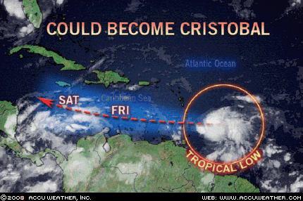
Cristobal will soon be named the next tropical storm as indicated in the last log. 3 days. Will this disturbance become Cristobal? We think so. The system may have a rough time revving up at first due to its proximity to South America, but once it reaches the central Caribbean it will be free to turn into a hurricane. Long range indicators suggest the storm will eventually track across the Yucatan and then head into Mexico without having any direct impact on the United States.
-
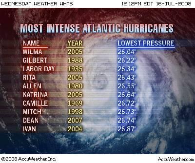
Most powerful hurricanes
-
Hurricane season getting longer.. Hurricane seasons have been getting longer over the past century and the big storms are coming earlier, LiveScience has learned. The trend has been particularly noticeable since 1995, some climate scientists say. Further, the area of warm water able to support hurricanes is growing larger over time. The Atlantic Ocean is becoming more hurricane friendly, scientists say, and the shift is likely due to global warming. "There has been an increase in the seasonal length over the last century," Jay Gulledge, a senior scientist with the Pew Center on Global Climate Change, told LiveScience. "It's pretty striking." A study Gulledge co-authored with other climate scientists found a five-day increase in season length per decade since 1915. Hurricane season officially starts June 1, but the first named storm of the 2008 season, Tropical Storm Albert, formed on May 31. The first hurricane of the season, Hurricane Bertha, formed on July 1, reaching hurricane strength on July 7, relatively early in the season for a major storm. In the last decade, more strong storms have been forming earlier in the season, said hurricane researcher Greg Holland of the National Center for Atmospheric Research in Boulder, Colo. While this trend hasn't been formally linked to global warming because climate models can't reproduce individual storms, Holland thinks it's likely that the warming caused by manmade greenhouse gases is a major factor in the seasonal shift based on observations of changes in recent decades and the predictions models are making for the changing conditions in the Atlantic basin. The length of the hurricane season is "one of the potentially big signals" that could change in response to global warming, Holland said. Defining the season The definition of the hurricane season depends on who you ask: For hurricane forecasters and coastal residents living in an area prone to hurricane landfalls, the standard dates are June 1 to Nov. 30. The National Hurricane Center uses these dates because historically most storms occur within that span of six months and because having a definitive time frame helps to heighten the public's awareness of the dangers of hurricanes. But for researchers looking at how hurricane activity has changed over time, those dates don't really matter - meteorologists look at the dates of the first and last named storms in a given year, which allow them to evaluate the actual length of each hurricane season. Since 1995, hurricane seasons have been increasing in length based on the latter definition, Holland said, with stronger storms that typically wouldn't be seen until mid-August showing up in July (Bertha, which became a Category 3 storm in the Atlantic last week, is one example). Expanding warm pool Like a hurricane's intensity, the length of the hurricane season is affected by the temperature of the ocean that fuels the storms. The warmer the water, the more energy a storm has to draw from. Hurricanes and tropical storms have been forming earlier in the season recently because "we now get warmer sea surface temperatures earlier in the year," Holland explained. "The whole season has extended out." Peter Webster of Georgia Tech put a finer point on it. "There is some work that says that the length of the North Atlantic hurricane season has become longer as SSTs [sea surface temperatures] warm up more quickly early in the season," he said. Tropical storms and hurricanes need water of at least 80 degrees Fahrenheit (26.5 degrees Celsius) to form. The area where water temperatures meet or exceed that mark is called the warm pool. In recent years, the warm pool has expanded, creating a larger area over which hurricanes can develop and strengthen, Holland told LiveScience. It is now reaching all the way to the coast of Africa, allowing storms to form farther east, and so giving them more time to strengthen as they traverse the Atlantic. Bertha, for example, formed farther east than any other July storm on record. These storms that form so far over in the eastern Atlantic are called "Cape Verde-type" storms, after the chain of islands off the western coast of Africa. Cape Verde-type storms account for a major proportion of all major hurricanes (Category 3 and higher), Holland said. These storms tend to take a straight westward path across the Atlantic, avoiding land and cooler waters, which can kill a storm. Hurricane Andrew, which devastated southern Florida in 1992, and 2007's Hurricane Dean, which wreaked havoc in the state of Yucatán in Mexico, were both Cape Verde-type storms, along with Bertha. Holland thinks that the growth of the warm pool will be a factor in the length of future hurricane seasons by promoting these and other early-forming storms. Other early storms, outliers to the standard June 1 to Nov. 30 season, such as this season's Tropical Storm Arthur or last year's Subtropical Storm Andrea (which formed on May 9), aren't all that unusual. Such early birds were seen even before global warming became an issue - the earliest-forming storm in recorded weather history was observed on March 7, 1908. "There's always been the odd one out," Holland said, adding that we'll likely see more of these in a warming world. "We have to expect that they'll be more outliers," he said, though he doubts that the official dates of hurricane season will change, since most will still lie within that window. But these aren't the early-forming storms that Holland is worried about, because they tend to be weaker. It's the major storms, like the Cape Verde-type, that are forming in July and later that are the ones to watch out for, he said. These shift to more major storms is also cause for concern because the Atlantic historically had fairly timid hurricane seasons compared to other storm-producing basins such as the Indian Ocean. Because the Atlantic basin wasn't optimized for hurricane formation already, "it didn't take much of a change to see a difference," Holland said. One other way the Atlantic basin is becoming more hurricane-friendly, besides warmer oceans, is more favorable atmospheric conditions. Warming ocean temperatures also change atmospheric circulation patterns. Holland said some changes are already happening over the Atlantic and climate models predict that these changes will also tend to promote the development of storms off the coast of Africa. "All of the stars are lining up," he said.
-
Cristobal le prochain systeme tropical dans 3 jours. Water temps steering air currents will allow this low to develop to a tropical storm. This one bears watching. Its now over the South-Central Atlantic.
-
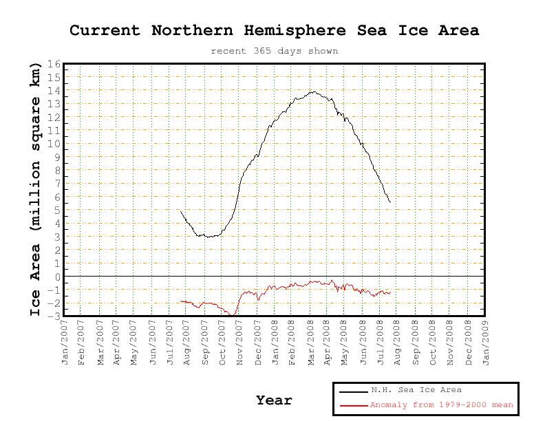
As we speak ice cover is above in northern and southern hemispheres. as for ice depth information will be available next week.
-
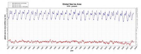
Global sea ice area
-
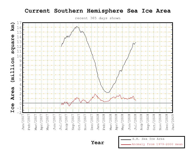
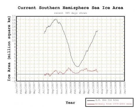
Current sea ice area for the Southern Hemisphere
-
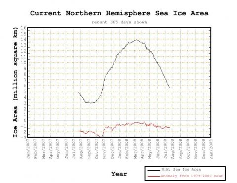
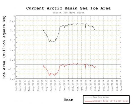
Current Arctic sea ice graph
-
WELL IF YOU COMPARE IT TO THE 1960S WE ARE FAR OFF. IF YOU COMPARE IT TO 1979 WERE DOWN BY 35%.COMPARED TO LAST YEAR WERE UP BY 25 %. LATEST INDICATIONS ARE THAT THE THICK YEARLY ICE THAT DOES NOT MELT SHOULD LAST THATS IF WE GET A LARGE NUMBER OF DAYS WITH CLOUDS AND LIMITED SUNNY DAYS.THIS WILL PREVENT THE FEED BACK FROM MELTING ICE AND SNOW.
-
ICE UPDATE JULY 5TH 2008.