-
Compteur de contenus
1 349 -
Inscription
-
Dernière visite
-
Jours gagnés
47
Type de contenu
Profils
Forums
Events
Gallery
Tout ce qui a été posté par iceberg
-
-
-
The week's hottest temperature was 114.1 degrees Fahrenheit (45.6 degrees Celsius) at Kosti, Sudan. The week's coldest temperature was minus 85.2 degrees Fahrenheit (minus 65.1 degrees Celsius) at the U.S. Amundsen-Scott South Pole Station, Antarctica. week of the 11th april 2008 ending - fin.
-
http://www.earthweek.com/2008/ew080411/ew080411a.html April 11, 2008 La Niña and El Niño are two natural Pacific currents that produce weather disruptions so vast that they resonate round the world.The head of the United Nations weather agency says that the current La Niña ocean cooling in the Pacific will cause global temperatures to be lower this year than in 2007, bucking a trend toward increased planetary warmth. Michel Jarraud told the BBC that La Niñas worldwide cooling effects are likely to continue into the northern summer, depressing temperatures globally by a fraction of a degree. Weather disruptions caused by La Niña over the past several months have included the coldest winter temperatures in memory across snowbound parts of China, and torrential rains in Australia as well as across parts of Africa. Climate experts at Britains Hadley Center for Climate Prediction and Research say the world can expect another record-warm year within the next five years or less. They believe the new record will probably be due to another episode of El Niño, the opposite phase from La Niña in the irregular cycle of ocean warming and cooling across the tropical Pacific. Animation: NASA
-
-
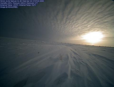
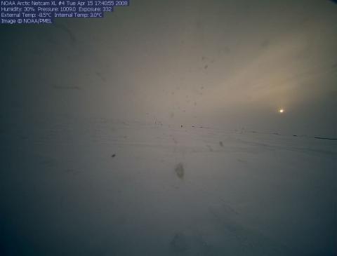
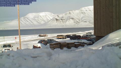
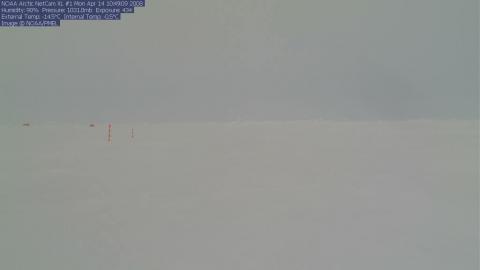
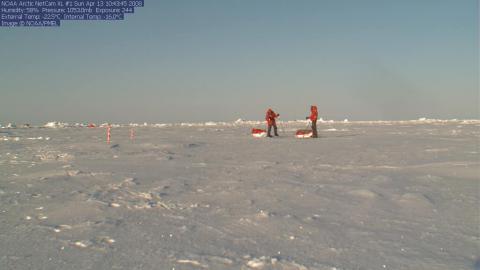
Four new web cams have been deployed at the North Pole, and photos are now available. In some of the earlier photos you will see members of the North Pole deployment team in action. Web Cam 3 is a fish eye view, allowing us to see more of the instrumentation in a single view. http://www.arctic.noaa.gov/gallery_np.html
-
-
South Pole Weekly Climate Summary for 29 Mar - 04 Apr, 2008 Weekly Climate Summary for 29 March 2008 through 04 April 2008 UTC South Pole Station, Antarctica Temperature: Average temp... -53.0°C / -63.5°F Maximum temp... -41.1°C / -42.0°F on day 2 Minimum temp... -63.8°C / -82.8°F on day 29 Wind: Average wind speed.......... 13.0 mph or 11.3 knots Prevailing wind direction... Grid Northeast Maximum wind speed.......... 37 mph or 32 knots on day 1 and day 2 Maximum wind direction...... Grid Northeast Average vectored wind....... 033 degrees at 11.0 knots Station Pressure: Average pressure... 683.2 mb Highest pressure... 692.9 mb on day 31 Lowest pressure.... 672.8 mb on day 3 Physio-altitude: Average physio-alt = 10508 ft/ 3203 m Highest physio-alt = 10901 ft/ 3323 m on day 3 Lowest physio-alt = 10145 ft/ 3092 m on day 31 Sky Cover: Average cloud cover (8ths)... 6 Days clear................... 0 Days partly cloudy........... 4 Days cloudy.................. 3 Sunshine: Sunrise on 20 September 2008 Average hours per day... 0.0 Percent of possible..... 0 Visibility: 3 days with visibility of 1/4 mile or less. Balloon flight data: Number of soundings for the week..... 7 Average height of soundings.......... 34.6 mb, or 22277 meters Highest sounding..................... 18.9 mb, or 25941 meters on day 29/00Z flight 0 soundings were missed. **RECORDS** No records were tied or broken this week.
-
-
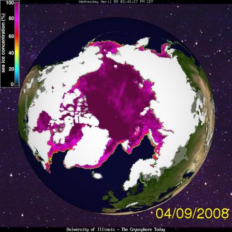
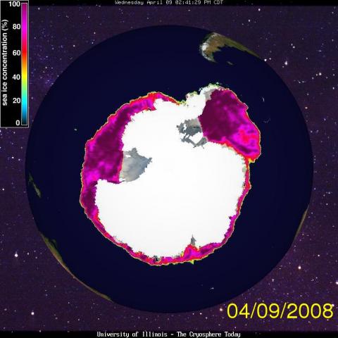
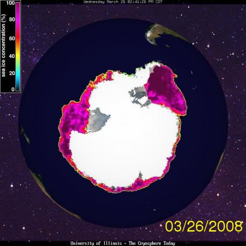
THE SCORE ON THE ICE !! Antarctic sea ice remains relatively healthy while the sea ice in the Arctic continues a precipitous decline in overall volume. Thats the latest state of the union report from NASA, which held a teleconference for the media on March 18, with three scientists presenting the latest analysis from satellite data. NASA satellite records on sea ice extent go back about 40 years. The area of Antarctic ice has been relatively stable in the past 35 years, said Seelye Martin, program manager of Earth Science Division at NASA headquarters in Washington, D.C. Martin said sea ice extent in the Antarctic has increased about 1 percent per decade during that time. In other words, its basically staying constant, he said. The news is far more grim in the Arctic, despite a slight increase in overall winter sea ice extent in March, when the sea ice pack peaks in the northern hemisphere. The concern is that the perennial sea ice the thick, multi-year ice that survives through more than one summer is rapidly declining in the Arctic. The area of the thicker, perennial ice has reached an all-time minimum, Martin said. In other words, the volume of the Arctic pack ice is continuing to decrease. Perennial ice used to cover 50 to 60 percent of the Arctic, but this year it covers less than 30 percent, according to NASA data from the satellites. Very old ice that remains in the Arctic for at least six years comprised over 20 percent of the Arctic area in the mid to late 1980s, but this winter it decreased to just six percent.
-
--Sundries: A nasty winter storm, even blizzard, gripped the eastern side of the island of Hokkaido, Japan, Tuesday. Snowfall was not extreme, but did reach about one foot at Nemuro and Abashiri. But winds were severe with gusts often reaching 50-55 knots (92-102 kmh) at Kushiro. The nearby Kuril Islands were also caught up in the wintry storms. --Soaking rain has pelted Paraguay this early week. A site called General Bruguez got 5.8 inches (14.7 cms) of rain Monday, mostly early in the day. There was rainfall of 4.7 inches (11.9 cms) at San Estanislao, 4.3 inches at Asuncion and 4.2 inches at Coronel Oviedo. --In Peru, a site high alog the Andes (Andahualyas) indicated rainfall of more than 8 inches within three days and 5.1 inches (13 cms) within less than 24 hours ending Tuesday morning. This is extreme rainfall for 11,000 feet (3400 meters) above sea level. --Vostok, site of extreme Antarctic weather deep in the heart of the icy continent, had its coldest day of the year thus far. Monday, the low was 91 degrees below zero (68.2 C below) and the high was 83 F below (63.8 C below). This is 8 degrees F below normal for the date. --South Africa: The Atlantic shore in southwestern South Africa was heated by winds blowing out of the Kalahari Desert. Capetown warmed to 97 degrees, or 36 C; this was 21 degrees F above normal. Elsewhere, 103 degrees F (about 39.5 C) was reached at Table Bay and Vredendal. --Tropical Weather: The tropical cyclone folk at the NRLMRY have their sights upon a blow-up of thunderstorms between Indonesia and northwestern Australia. This is somewhat east of the last tropical cyclone, TC Pancho. If we do get a tropical cyclone here, numerical forecasts suggest a track toward the northwest shore of Australia over the next two to three days.
-
FUTURE OUTLOOK TILL 2038 AD MAP chart.pdf
-
-
An Active 2008 Tropical Storm and Hurricane Season Ahead An active tropical storm and hurricane season may be just around the meteorological corner. We are predicting above normal numbers of named storms in the Atlantic and Caribbean waters for the 2008 season. Since the middle of 2007, global weather patterns have been influenced by La Nina, the cooler than normal sea-surface temperature event in the Equatorial regions. Within the last month, ocean waters in the south-central Pacific Ocean have been warming, indicating that La Nina is weakening. In the Atlantic and Caribbean waters, sea-surface temperatures are at near-normal levels, but warmer than average in the Gulf of Mexico. This recent rise in ocean temperatures would help intensify tropical storm development. For the 2008 season, Harris-Mann Climatology predicts 18-21 named storms with twelve of them becoming hurricanes. Four of these potentially deadly storms are expected to become major hurricanes, reaching at least a Category 3 status. The overall average is 10 named storms with 6 becoming hurricanes during an entire season, which begins on June 1 and ends November 30. In the eastern Pacific Ocean, above normal numbers of tropical storms and hurricanes are expected as well. The 2005 tropical storm and hurricane season was indeed the most active in recorded history. Named storms in the Atlantic and Caribbean waters started to be logged in 1851. Up until 2005, the most active hurricane season ever seen was in 1933 with 21 storms reaching tropical storm status or greater. In 1995, there were 19 named storms. In 2005 and early 2006, we saw a record 27 named storms. Also, for the first time in history, the entire list of names were used so Greek letters were implemented ending with Hurricane Zeta, the strongest and most long-lasting January hurricane in recorded history. As far as the number of hurricanes, the 2005 season also broke the record with 14 storms. Seven of these hurricanes were considered to be major. The previous record was 12 hurricanes in 1969. The 2005 hurricane season will go into the record books as the costliest ever, even topping the damage from Hurricane Andrew in 1992. Believe it or not, only three Category 5 storms have ever hit the U.S. Mainland over the last 100 years. These were Camille in 1969, Andrew in 1992 and the Labor Day storm (no name) of 1935. Katrina, Rita and Wilma in 2005 did reach Category 5 status, but weakened before they made landfall. The effect of warmer sea-surface temperatures definitely plays a role on hurricane development. According to a recent Time Magazine article, between 1920 and 1970, ocean waters were warmer and hurricane activity was high. However, as sea-surface temperatures cooled in the 1970s, 1980s and early 1990s, we saw a decrease in tropical storms and hurricanes. Since 1995, however, ocean waters have turned warmer than normal again leading to above average hurricane seasons, except during the big El Nino years of 1997 and 2002. In 2005, ocean water temperatures were as much as 3-6 degrees Fahrenheit above normal. In 2006, there were 10 named storms, 5 hurricanes and two major hurricanes. The number of named storms were slightly above normal in 2007. Last year, there were 15 named storms, including 6 hurricanes, which included two major storms.
-
Are We Entering a Period of Sudden 'Global Cooling'? The total extent of snow cover in the Northern Hemisphere at the end of February was at the highest level since the same period 42 years ago in 1966. The all-time record for extreme snow depths was during the winter of 1887-88. According to my climatological colleagues in Britain, Japan and the U.S., the winter months of December, January and February were likewise the coldest as a whole since at least the late 1970s, in some cases dating back to either the 1930s or even the 1880s. One area of southeastern China claims that this exceptionally harsh winter of 2007-08 has been the "worst since 1210, nearly 800 years ago!" As I mentioned last week, large portions of China were literally paralyzed in early to mid February by unprecedentedly heavy snowfalls and temperatures at times at record low levels. Tens of millions of Chinese New Year celebrants were left stranded with no food, water or shelter. More than 25,000 miles of power lines in southern China collapsed under the weight of snow and ice in areas that rarely even see the white stuff. The Chinese Government had no way of coping with the unique meteorological event. For example, there were no snowplows and there wasnt any salt to put on the icy roadways. The severe winter conditions killed at least 40% of the 2007-08 rapeseed crop (canola), a staple in China. This forced the Chinese to buy our record-high priced $15-a-bushel soybeans to stave off widespread food shortages. Its now estimated that the cost of this disaster to the Chinese economy will easily exceed $4 billion. Southeastern Chinas losses alone will top $2 billion. Elsewhere around the Northern Hemisphere, as we also reported in past weeks, the death toll in Afghanistan from this winters record cold and heavy snowfalls has climbed to above 1,200 persons. Neighboring Tajikistan, according to various aid agencies, has seen its most frigid winter season in at least 50 years, along with soaring food prices and a massive energy crisis which has threatened a "humanitarian catastrophe of Biblical proportions." Heavy snowfalls just this past week closed many roads in Greece, Turkey, Syria and Iran. Some of the lowland regions in normally warm southern Iran reported their "first measurable snowfalls in living memory." In parts of Saudi Arabia, people were amazed when children actually found enough snow in one town to build a large snowman. Rare snows also fell in the lowland areas of Israel where they grow bananas! Cairo, Egypt likewise saw snow. Blizzards have crippled much of Asia and Europe this winter. Record snowfalls in Japan literally buried many cities causing death and injury to hundreds of persons. Canals and other waterways were closed in Europe due to severe icing conditions. Snow removal crews, in some cases, took nearly two full weeks to clear many roads in Germany, Austria and Poland. The Yorkshire Dales in Britain, normally a mild part of England, were hit this past week by heavy snows and a "cascade of icicles" reminding local residents of the rough winters during World War II. In the U.S., record snowfalls have hit more than 20 states this winter from Washington and Oregon eastward through Idaho, Iowa, Wisconsin and New England. Rare snows were seen as far south as northern Alabama this past Wednesday, February 27. Furthermore, its not only the Northern Hemisphere thats experiencing an unusual frigid period. We reported freak snows last July and August in the Southern Hemisphere in places like Buenos Aires, Argentina, Sydney, Australia and even a few flakes were seen in Minas Gerais in Brazil for the first time in recorded history. Last August 31, the total icepack in Antarctica was "the most extensive since such data began in 1979, at least 8% greater than at its lowest point in February of 1998." Icebergs were seen as far north as New Zealand. According to Cambridge University scientists, the seven-tenths of a degree Fahrenheit drop in global temperatures in just the past six months has been the most pronounced plunge since the 1.2 degree dip in the year following the volcanic eruption of Mount Pinatubo in the Philippines in June of 1991. They blame changes in the decrease in solar radiation for the current sudden cooling. It had nothing to do with rising carbon dioxide levels, one way or the other. Global warming skeptics are inevitably pointing to this harsh winter of 2007-08 as evidence that the planets temperatures are no longer rising as the carbon dioxide levels suggest would be the case. Several of my climatological peers are saying that "weve begun a period of global cooling that will soon reverse the 30-year uptrend in temperatures since 1978." Remember, the four decades preceding 1978 were called by most climate experts as "The Little Cooling." My friend, Dr. Iben Browning, in the late 1970s, was predicting a new Little Ice Age, an extended period of time when Canada and many parts of northern Europe and Asia would be unable to produce crops due to "critically short growing seasons with frequent freezes," much like what has occurred in the past year or so in many of the worlds major grain producing regions like China, Argentina and the U.S. Record high grain and soybean prices have resulted from these killer frosts on a global scale. I agree with another climatologist friend, Paul Berenson, who stated on February 21: "The truth is that its still much too early to draw any long-term conclusions from 2008's great freeze. But, it is indeed one of the most startling recent developments to have emerged in the worlds weather patterns for a long time. At the least, it was so unexpected. It raises important questions for millions of people worldwide whose lives have been seriously disrupted by this years freezes. To them, the concept of global warming must seem awfully remote." RANDY MANN AND VERY GOOD FREIND OF MINE.
-
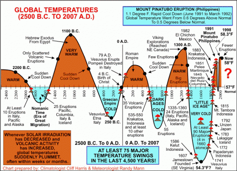
120-Year Climate Study No one argues that our weather has been very EXTREME over the last few decades, especially during the past several years. Most scientists believe that our global climate is changing, but is our weather being altered by Mankind's influence, or is it merely a part of a long-term climatological cycle? According to our long-term charts, which date back to 600 B.C., there are numerous climatological cycles that influence our weather and other global events including global and national economies. For example, during "Warm-Wet" cycles, like those in the 1920s and the 1990s, we often saw above average global temperatures and precipitation. This situation often leads to bumper crops and very good worldwide economic conditions. However, when temperatures are warmer than average and precipitation falls to below normal levels, less favorable times, or even depression eras like those of the 1930s and the past several years are more likely. Cooler and drier phases often point to "calm" periods like the 1950s and early 1960s. Cycles that become too hot and dry or too cold and dry will often lead to very unfavorable periods, such as the one expected later century, near 2038. Only time will tell. For many years, following widespread ICE AGE predictions back in the 1970s, we've heard that our planet is warming up "at an alarming rate". A study from the National Academy of Science claims that "global warming is real and has been strengthening since 1981." These scientists say that the leading cause of this latest warming is the increasing emissions of greenhouse gases and carbon dioxide. They also state that by the year 2100, temperatures may increase by 2.5 degrees to as much as 10.4 degrees Fahrenheit above those of today. Up until late 2002, much of the Northern Hemisphere north of Latitude 40 was actually becoming GREENER with less total ice. In fact, the average growing season had been extended by around 2 weeks based on satellite data at the time. BUT, now, we believe that temperatures are beginning to cool again, particularly in north- central Canada where this summer there was only about 2 weeks between damaging freezes from late June into mid-July. One of our Climatology clients went fishing between July 10-13 in northwestern Saskatchewan and reported "piles of ice" still on the ground in the region and temperatures close to the freezing mark. Although the recent summers of the early 21st Century have been amongst the hottest and driest on record across most of the U.S., the winter seasons, by extreme contrast, have been some of the coldest in recorded history. For example, Siberia in Russia reported readings of -70 degrees in January of 2001. Even if our planet is warming up as many scientists claim, we're still much cooler today than we were four to eight-thousand years ago. In fact, there were probably no mid-latitude glaciers about 800 million years ago, because the Earth's climate was so mild at the time. Temperatures today are primarily measured over concrete surfaces compared to grassy ones years ago. We all know that concrete and asphalt absorb heat and this often results in higher afternoon temperatures, especially when we have conditions of very little wind. During a typical hot, summer day, high temperatures may be as much as 3-7 degrees warmer at the official airport or downtown locations compared to outlying rural areas. A comprehensive climatological study of over 600 cities both in North America and around the rest of the world, which I finally completed in mid-2001, compared the average (mean) temperatures in Fahrenheit for the six decades from 1880 through 1940 and the following 60-year period ending December 31, 2000. Needless-to-say, I was a bit surprised to discover that this planet overall had only warmed up a mere .7 of one degree Fahrenheit on a global scale from 1941 through the balance of the 20th Century. In fact, if one removed the 15 largest cities, the "concrete and asphalt jungles", from the study, Mother Earth would have actually COOLED OFF about .4 of one degree Fahrenheit in the last six decades. Tokyo, Mexico City, Sao Paulo, Mumbai (Bombay), Seoul, Beijing, Osaka, Rio and Delhi each warmed up by more than a full degree Fahrenheit between 1941 and 2001. In the U.S., only Los Angeles, Phoenix, Dallas, St. Louis, Oklahoma City, Mobile, Alabama, Houston, Salt Lake City, San Jose and Sacramento warmed by a degree or more Fahrenheit during the same 60-year time span. Even New York City, Philadelphia, Baltimore, Boston, Washington, D.C. and Miami along the Atlantic Coastline only warmed up slightly, despite the so-called "heat island" effects. There were dozens of cities, mostly with populations under 300,000 people, that actually turned COOLER during the balance of the 20th Century. These cities included; Billings, Montana, Bismarck, North Dakota, Boise, Idaho, Fargo, North Dakota, Fairbanks, Alaska, Seattle, Washington, Spokane, Washington and Coeur d'Alene, Idaho which cooled by .4 of one degree Fahrenheit from 1941 to 2001. As previously mentioned, temperatures today are primarily observed over concrete or asphalt surfaces, rather than those "grassy knolls" of years past. We all know that concrete and asphalt absorb heat and this often results in higher afternoon temperatures, especially when we have conditions of very little wind. During a typical hot, summer day, high temperatures may be as much as 3-7 degrees warmer at the official airport or downtown locations compared to outlying areas. Robert Felix, author of "Not By Fire, But By Ice" discusses the possibility of an upcoming ICE AGE within the next 20-30 years. He claims, and has the data to prove it, that many glaciers are expanding worldwide, some as much as 18 feet per year and that sea levels have "dropped" slightly since the early 1990s. According to Felix, major ice ages occur about every 11,500 years with the last one occurring nearly 12,000 years ago, so we're supposedly overdue for a BIG COOLING TREND, which may have already begin as Greenland's and Antarctica's ice sheets are thickening at a rapid pace. Our climate would also cool very quickly if we were to see a series of MAJOR volcanic eruptions take place over a short period of time. Since the early 1990s, there has been an overall significant increase in volcanic activity in the Philippines, Japan, Indonesia, El Salvador, Tanzania, Mexico, Columbia, Italy, Alaska and our Pacific Northwest. Since the late 1990s, we've likewise seen a dramatic increase in undersea volcanic eruptions, especially in the western Pacific Ocean regions. Global temperatures cooled rather dramatically following the massive Mt. Pinatubo eruption in June of 1991 in the Philippines. Nearly 200 years before, there was an even more dramatic global cooling associated with the eruption of Mt. Tambora in 1815, which put an incredible EIGHT TIMES more volcanic material into the upper atmosphere than the recent strong eruption of Mt. Pinatubo. The following year, 1816, is still being referred to by New England's historians as "Eighteen-Hundred and Froze to Death". Snow fell every month that year at the higher elevations in the interior Northeast while freezes blackened crops that summer in the valleys from northern New England and southeastern Canada all the way south into the Carolinas. In the past few years, we've started to see a trend towards later frosts in the spring and earlier freezes in the fall seasons, despite the warmer than normal temperatures. Whether we continue to warm up or cool down still remains to be seen, but there's no doubt that we're in a long-term cycle of Wide Weather "EXTREMES". Stay tuned...
-
MORE EXTREME WEATHER MAY BE IN STORE FOR AT LEAST ANOTHER 35 YEARS Since mid-1967, we have seen more long-standing weather records broken worldwide for both temperature and precipitation than we did from the end of the Civil War until the late 20th Century. Based on our long-term weather charts that date back to 600 B.C., we may be only halfway through a long-term 70-YEAR GLOBAL CYCLE OF WIDE WEATHER "EXTREMES" that began in the late 1960s and probably won't end until at least the late 2030s. The weather, like many other things does appear to go through a variety of short and long-term cycles. Have you ever noticed that rain will fall on a particular day during the week (usually the weekend days from what I hear) for about a month? Or, we'll notice one region getting deluged from record precipitation while other parts of the country are suffering from parching drought? Well, Climatologist Cliff Harris and I believe that the weather does have a number of cycles that range from nearly 7 days to 6 weeks and much longer. This particular global cycle of wide weather EXTREMES seems to occur about every 500 years. Since this cycle began, we've seen at least 70,000 worldwide records fall that once stood for over 200 years. Since we're only about half way through this cycle, we can obviously expect more extreme weather conditions. The Winter of 2007-08 was indeed one of the harshest in recorded history across the globe. There have been record snows across parts of the Inland Northwest that have raised fears of major flooding. In February alone, there have been heavy snows near the Great Lakes. We just had one of the worst February outbreaks of tornadoes in the mid-South early in 2008, with the worst in eastern Arkansas and western Tennessee with severe flooding in the Ohio Valley. Severe ice storms have also plagued Kentucky, Illinois, Indiana and Ohio. Schools were closed in southern Illinois for the first time since the 1980s. In February, 2008, Minnesota plunged to an all-time record -40 degrees this morning, a place officially known as the nations "icebox." Many places across the northern regions of the U.S. experienced temperatures from -20 to -35 degrees. Arctic cold also gripped Europe as records were shattered due to the extreme conditions. Vienna, Austrias subway tracks cracked and German authorities had to shut down a key water canal after it iced up. Heavy snows fell on Greeces elevated ancient Acropolis and lighter snows covered much of nearby Athens. One lake in Siberia, where temperatures dipped to an all-time low of -64 degrees, reported ice as much as 13-feet thick which killed most of the fish. Even normally mild southern China has seen blizzard conditions making this one of the most severe weather seasons in over 800 years. Over 40% of the Chinas winter rapeseed (canola) crop has been lost to cold, snow and ice. Afghanistan has also observed rare blizzards this winter season resulting in the deaths of hundreds of people. "Rare" snow were likewise observed in normally warm Baghdad, Iraq; Cairo, Egypt; Palermo and Sicily in the "boot" of Italy; Istanbul, Turkey and Jerusalem in Israel, just to name a few spots. In the last 10 years, we've also seen disastrous 500-YEAR FLOODS in the Midwestern U.S. There have also been big floods throughout much of Central Europe and parts of Russia in 2002 that caused billions of dollars in property damage. In 1998-99, Mt. Baker in Washington State recorded the highest worldwide snowfall ever with 1,140 inches. While some parts of the world receive the flooding rains, as mentioned earlier, others have seen some of the WORST DROUGHTS in 400-500 years in parts of the U.S., Mexico and central Canada as well as across portions of Asia, much of Africa, Australia, extreme southern Europe and the Mediterranean regions. For example, the western U.S. Great Plains, the Desert Southwest and Southern California experinced the worst drought conditions since the infamous DUST BOWL DAYS of the 1930s back in 2006. Since the early 1990s, we've experienced the WARMEST period overall since the last cycle of global warming about 1,000 years ago. Believe it or not, temperatures were even milder than what they are today. During that time, it was warm enough that the Vikings were farming parts of southwestern Greenland. But, 200 years later, the climate drastically changed and the so-called LITTLE ICE AGE brought bitter cold and snow to that region forcing the Vikings to evacuate. But, in early 2008, global temperatures have dropped approximately seven-tenths of a degree Fahrenheit since August of 2007. Sunspot activity has noticeably quiet in early 2008. We eventually see more sudden shifts in the fast-moving upper-level jet stream winds that help steer weather systems around the planet. These global shifts in climate tend to occur with the arrival of the virtually every El Nino, the abnormal warming of ocean waters, or La Nina, the abnormal cooling of sea-surface temperatures in the South-Central Pacific Ocean along the Equatorial regions near the West Coast of South America. Within the last several years, we've seen dramatic warming and cooling of ocean temperatures within very short periods of time. So when will we finally get out of this Cycle of Wide Weather Extremes that's the strongest in about 1,000 years? Well, this particular cycle usually lasts about 70 years. Since it started around 1967, it probably will not peak until at least 2038 and possibly will become the worst such climatological cycle in at least 6,000 years. Until then, expect more long-standing weather records to fall. But, there may be a brief break in this weather pattern. Cliff is forecasting a brief period of "calm" from these extremes around 2010, give or take a few years either way. However, the EXTREMES are expected to return and perhaps become even more severe from about 2017 to 2038. Only time will tell. By Meteorologist Randy Mann.
-
GLOBAL TEMPERATURE EXTREMES The week's hottest temperature was 115.7 degrees Fahrenheit (46.5 degrees Celsius) at Saint-Louis, Senegal. The week's coldest temperature was minus 89.9 degrees Fahrenheit (minus 67.7 degrees Celsius) at Russia's Vostok Antarctic research station. WEEK OF APRIL 4TH 2008.
-
These winter rankings are from 1600 to 2008. Only winters with extremely severe to very severe and to severe made the list. 1=2=3=4 are rated SEVERE.5=6=7= are rated VERY SEVERE.8=9=10 are rated EXTREMELY SEVERE. These rankings could change in future updates as more information is obtained from the archives or emailed to me from various sources.The mean average temperture and snowfall totals are for McGill and from December till March .The winter years before that are ranked also for Montreal winters and area for the north east. Before 1871 official totals for weather information were given out only for military naval and outposts in remote areas.There is so much data to comply before 1871 and to give out a average temperture and snowfall amount will be hard.But i think its still possbile to give out some informaton before 1871 for Montreal and area.I will try to put out something in the future. The rankings i made were based on how hard the winter was. So twice or once a week i will write a small story on each winter season starting from no.38 and going down to no.1. The king of all winters 1697-98. I will also leave a map chart at the end of the rankings and you could see where the warm periods began and the ice ages also. I hope you enjoy this. Thank You, Merci Beaucoup RANK.... YEAR.... CLASS.... TEMP/AVG.... SNOWFALL 1...... 1697-98.... 10 2...... 1740-41.... 9 3...... 1641-42.... 9 4...... 1604-05.... 9 5...... 1732-33.... 9 6...... 1680-81.... 9 7...... 1783-84.... 9 8...... 1637-38.... 8 9...... 1764-65.... 8 10.... 1779-80.... 7 11.... 1835-36.... 7 12.... 1798-99.... 7 13.... 1719-20.... 7 14.... 1704-05.... 7 15.... 1819-20.... 6 16.... 1831-32.... 6 17.... 1705-06.... 6 18.... 1747-48.... 6 19.... 1856-57.... 6 20.... 1817-18.... 6 21.... 1836-37.... 5 22.... 1867-68.... 5 23.... 1884-85.... 5.... -10.7.... 322.1 24.... 1903-04.... 5.... -10.5.... 289.8 25.... 1933-34.... 5.... -10.5.... 228.3 26.... 1874-75.... 5.... -10.9.... 217.5 27.... 1886-87.... 5.... -10.0.... 349.5 28.... 1904-05.... 5.... -10.4.... 298.2 29.... 1887-88.... 4..... - 9.9.... 298.7 30.... 1917-18.... 4.... -10.3.... 293.4 31.... 1882-83.... 4.... -10.3.... 286.8 32.... 1970-71.... 4..... - 9.4.... 364.2 33.... 1883-84.... 3..... - 9.0.... 299.2 34.... 1906-07.... 3..... - 9.2.... 276.6 35.... 1993-94.... 3..... - 9.3.... 230.8 36.... 1958-59.... 3..... - 9.2.... 244.1 37.... 1878.79.... 3..... - 8.3.... 330.5 38.... 1892-93.... 3..... - 9.3.... 159.5
-

CLASSIFICATION OF SEVERE WINTERS
iceberg a répondu à un(e) topic de iceberg dans Discussions générales
For Rockabills Question ?? Ive been always fasinated in weather history since i was 7 years of age.And i do believe that in studying the earths weather history you can forcast the future. There are cycles that come and go.We only know so much but not enough. But if we could figure out the cycles we could somehow forcast some large events into the future of weather forcasting.Weather data only goes back to 1604 and that information is on documentation by colonists. Even Jacques Cartier who wintered near Quebec in 1535-36 had a very mild winter posted in his logs and that was part of a cycle that would come to haunt European settlers starting in the year 1604. -

CLASSIFICATION OF SEVERE WINTERS
iceberg a répondu à un(e) topic de iceberg dans Discussions générales
I will soon post a new classification of winters from 1604 to 2008. This classification will be ranked in order of severity.Im very sorry if ive caused any problems with this being in english. I do speak french very well but i cannot write in french very well so like Shawn said in his post if he would like to translate this it would be very welcome. Merci . -

CLASSIFICATION OF SEVERE WINTERS
iceberg a répondu à un(e) topic de iceberg dans Discussions générales
This data is part of my weather collection which ive obtained for the past 28 years. Weather history books, manuscipts and of course from the american library. Many books were not reprinted anymore so much of the data is archived at the american library which ive obtained during my years of collecting this data. There is so much data dating back to 1604 and i will share it with this forum in the coming years. I hope you will enjoy it. -
CLASSIFICATION OF WINTERS FROM 1697 TO 1799 PART 1 OF 4 RANKING ORDER...... ( NOTES ) 1. 1697-98 = EXTREMELY SEVERE 2. 1740-41 = VERY SEVERE 3. 1704-05 = VERY SEVERE 4. 1705-06 = VERY SEVERE 5. 1732-33 = VERY SEVERE 6. 1719-20 = VERY SEVERE 7. 1764-65 = VERY SEVERE 8. 1783-84 = VERY SEVERE 9. 1798-99 = VERY SEVERE 10. 1747-48 = VERY SEVERE 11. 1798-99 = VERY SEVERE 12. 1779-80 = VERY SEVERE NORTH EASTERN WINTERS
-
Not to be alarmed about the massive breakup of the willkins shelf its only been 200 years its been there only taking its natural cycle and of course the massive weight does not help. A new shelf will take its place in 500 years time.
-
A study of George VI Ice Shelf on the Antarctic Peninsula is the first to show that this currently healthy ice shelf experienced an extensive retreat about 9500 years ago, more than anything seen in recent years. The retreat coincided with a shift in ocean currents that occurred after a long period of warmth. Whilst rising air temperatures are believed to be the primary cause of recent dramatic disintegration of ice shelves like Larsen B, the new study suggests that the ocean may play a more significant role in destroying them than previously thought. The University of Durhams, Dr Mike Bentley, one of the leaders of the project said, We know that rising air temperatures can break up ice shelves but there has been a suspicion for some time that the role of the ocean may have been underestimated. This is some of the first evidence that a shift in ocean currents can actually destroy ice shelves. In this case its possible that a preceding warm period may have primed the ice shelf to disintegrate when the ocean currents shifted. The scientists analysed sediments from the bottom of a freshwater lake close to the edge of the present George VI Ice Shelf. The results revealed that about 9500 years ago the ice shelf retreated, allowing the sea to flood into the lake. The ice shelf didnt reform until 1500 years later, and has been present ever since. The findings are particularly relevant for other studies on the West Antarctic Ice Sheet where scientists have found that a relatively warm current, Circumpolar Deep Water, is causing high melt rates on the underside of an ice shelf in Pine Island Bay*. The gradual removal of this ice shelf may be causing the glaciers inland to flow faster, which could lead to enhanced drainage of part of the West Antarctic Ice Sheet, and a consequent rise in sea level.


