iceberg
-
Compteur de contenus
1 349 -
Inscription
-
Dernière visite
-
Jours gagnés
47
Type de contenu
Profils
Forums
Events
Gallery
Tout ce qui a été posté par iceberg
-
Observations du 9 au 10 décembre 08
iceberg a répondu à un(e) topic de Yannis30 dans Discussions générales
Montreal-Est Neige avec Grésil mêlé de Pluie Verglaçante -8.2c 9:04 pm Montreal -East Snow mixed with Ice Pellets and Freezing Rain -8.2c 9:04 pm http://www.accuweather.com/enhanced-radar....ther&traveler=0 http://www.intellicast.com/National/Radar/...cation=USVT0147 -
Observations du 9 au 10 décembre 08
iceberg a répondu à un(e) topic de Yannis30 dans Discussions générales
Montreal-Est Neige avec Grésil mêlé de Pluie Verglaçante -8.7c 8:53 pm Montreal -East Snow mixed with Ice Pellets and Freezing Rain -8.7c 8:53 pm http://www.accuweather.com/enhanced-radar....ther&traveler=0 -
montreal-est Généralement dégagé -20.1c 3:53 am montreal-east Mainly clear -20.1c 3:53 am
-
montreal-est Généralement dégagé -13.6c 9:02 pm montreal -east Mainly Clear -13.6c 9:02 pm
-
montreal-est neige faible -4.1c Températures à la baisse 4:52 pm montreal-east light snow -4.1c Temperature falling 4:52 pm http://www.accuweather.com/enhanced-radar....ther&traveler=0
-
montreal-est Nuageux avec éclaircies -3.3c 9:44 am montreal-east partly cloudy -3.3c 9:44 am
-
montreal-est Généralement nuageux 0.5c 5:53pm montreal-east mostly cloudy 0.5c 5:53pm
-
montreal-est Généralement nuageux 3.6c 3:50pm montreal-east Mostly Cloudy 3.6c 3:50pm
-
OBSERVATIONS 30 nov. soirée - 1er décembre 2008
iceberg a répondu à un(e) topic de Pierre dans Discussions générales
radar indicates cold air aloft over central laval moving south east toward montreal east and the reason behind the thunder. -
OBSERVATIONS 30 nov. soirée - 1er décembre 2008
iceberg a répondu à un(e) topic de Pierre dans Discussions générales
montreal-est faible pluie avec orage 3.4c 6:02pm montreal-east light rain with thunder 3.4c 6:02pm -
OBSERVATIONS 30 nov. soirée - 1er décembre 2008
iceberg a répondu à un(e) topic de Pierre dans Discussions générales
montreal-est Grésil avec pluie faible -0.2c 2:18am montreal-east ice pellets with light rain -0.2c 2:18am -
OBSERVATIONS 30 nov. soirée - 1er décembre 2008
iceberg a répondu à un(e) topic de Pierre dans Discussions générales
montreal-est Neige faible -0.4c 11:01pm montreal-east light snow -0.4c 11:01pm -
OBSERVATIONS 30 nov. soirée - 1er décembre 2008
iceberg a répondu à un(e) topic de Pierre dans Discussions générales
montreal-est Neige faible -0.2c 9:48pm montreal-east light snow -0.2c 9:48pm -
OBSERVATIONS 30 nov. soirée - 1er décembre 2008
iceberg a répondu à un(e) topic de Pierre dans Discussions générales
montreal-est Nuageux 1.7c 5:54pm montreal-east cloudy 1.7c 5:54pm -
OBSERVATIONS 24-25-26 novembre 2008
iceberg a répondu à un(e) topic de Pierre dans Discussions générales
montreal-est Bruine faible 2.2c 5.23pm -
OBSERVATIONS 24-25-26 novembre 2008
iceberg a répondu à un(e) topic de Pierre dans Discussions générales
montreal-est Pluie faible 0.9c 7:46pm -
OBSERVATIONS 24-25-26 novembre 2008
iceberg a répondu à un(e) topic de Pierre dans Discussions générales
montreal -est Neige légère 0.4c 3:35pm -
OBSERVATIONS 24-25-26 novembre 2008
iceberg a répondu à un(e) topic de Pierre dans Discussions générales
montreal -est Neige légère -1.3c 10:45pm -
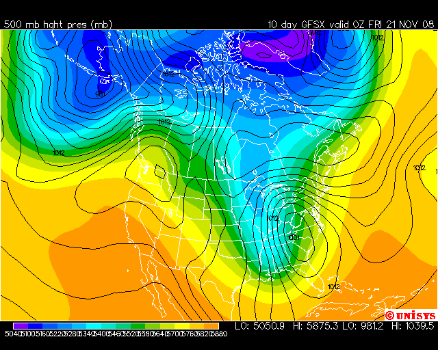
DISCUSSIONS ÉVÉNEMENTS du 17 au 23 novembre 2008
iceberg a répondu à un(e) topic de Trapper dans Discussions générales
des chances pour un nor easter ??? a 10 jours !!!!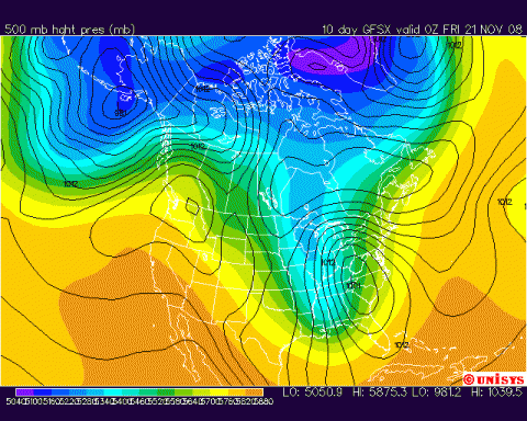
-
Rechauffement Climatique Global Warming
iceberg a répondu à un(e) topic de iceberg dans Discussions générales
in general ..... Globally October in most data bases maintained about the same level as September with one glaring exception, Hansens NASA GISS. There may be a second high value in the next few weeks, NOAA GHCN shares many of the same data points and adjustments or lack thereof will probably come in on the high side. Hadley Centre also will not report also for another week. It has remained more in line with the satellite in recent years. The data bases all have different base periods, which contribute to the relative differences. NASA uses the coldest base period 1951 to 1980, Hadley the second coldest 1961 to 1990, UAH and RSS MSU the warmest 1979 to 1998. It was mild in parts of southeast Europe and Asia in October. The arctic ice developed at a record pace in October, but snowcover was slow to increase until the last week. It has now quickly expanded to just above the normal for the hemisphere for the date. The plot of temperatures since 2002 is remarkable for the departures shown. NASA GISS is a full degree F warmer than the satellite measurements, which continue the downtrend of 0.2C since 2002. Even with the bogus warmth, GISS depicts a small downtrend. -
Rechauffement Climatique Global Warming
iceberg a répondu à un(e) topic de iceberg dans Discussions générales
GISS Releases (Suspect) October 2008 Data here is the link.... http://wattsupwiththat.com/2008/11/10/giss...ober-2008-data/ -
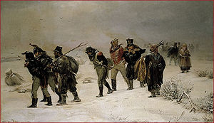
Rechauffement Climatique Global Warming
iceberg a répondu à un(e) topic de iceberg dans Discussions générales
Did Napoleon Use Hansen's Temperature Data? here is the link ... http://www.climateaudit.org/?p=4318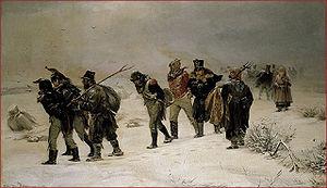
-
Rechauffement Climatique Global Warming
iceberg a répondu à un(e) topic de iceberg dans Discussions générales
just in .... Update: Thanks to an email from John S. - a patron of climateaudit.org - we have learned that the Russian data in NOAA�s GHCN v2.mean dataset is corrupted. For most (if not all) stations in Russia, the September data has been replicated as October data, artificially raising the October temperature many degrees. The data from NOAA is used by GISS to calculate the global temperature. Thus the record-setting anomaly for October 2008 is invalid and we await the highly-publicised corrections from NOAA and GISS. -
Rechauffement Climatique Global Warming
iceberg a répondu à un(e) topic de iceberg dans Discussions générales
2008 set to be about 10th warmest year: expert here is the link .... http://www.reuters.com/article/reutersEdge...E4AA6MV20081111 -
Current & Recent NCEP/NCAR Reanalysis Snowcover Statistics here is the link.... http://moe.met.fsu.edu/snow/