iceberg
-
Compteur de contenus
1 349 -
Inscription
-
Dernière visite
-
Jours gagnés
47
Type de contenu
Profils
Forums
Events
Gallery
Tout ce qui a été posté par iceberg
-
http://www.solarcycle24.com/index2.htm voici le lien........ information sur les aurores boréales et autres.....
-
After a weak warm up at the end of last week, Prairie temperatures plummeted again over the weekend reaching an all-time low in Edmonton. At one point on Saturday night, Edmonton had the dubious distinction of being the coldest place on Earth. The record low temperature of -46 degrees was measured at the Edmonton International Airport. With the Wind Chill, it felt colder than -50. The city itself was a balmy -35 degrees before factoring the Wind Chill. Edmonton's frigid temperature was exceeded by a station in Siberia where the lowest temperature measured on Saturday night was -48 degrees. Edmonton's -46 degrees was 2 degrees off the coldest temperature ever recorded for the Airport. Set back on January 26, 1972, the coldest temperature recorded is -48.3 degrees. Saturday also saw the coldest low ever recorded at the Airport in December. Friday, Saturday and Sunday nights also saw record low temperatures for Edmonton Airport. Temperatures will continue to be frigid for the next couple of days before warming up mid-week. On Thursday, Edmonton is currently expected to reach a high of 2 degrees! FROM APP
-
HERE ARE SOME WEATHER RECORDS THAT FELL.... Location record previous record records Min temp record year began (celsius) temp Coronation...... -39.7 -33.2 2008 1928 Edmonton int'l.. -46.1 -36.1 2008 1960 Edmonton muni... -36.0 -32.8 1882 1880 Lloydminster.... -37.5 -37.2 1917 1904 Cold Lake....... -36.5 -34.4 1975 1952 Grande Prairie.. -43.7 -37.8 1948 1922 Whitecourt...... -35.8 -34.4 1968 1942 Lacombe......... -37.3 -36.1 1963 1907 Sundre.......... -34.6 -28.7 2000 1985 Drumheller...... -34.0 -33.9 1975 1954
-
DISCUSSIONS PRÉVISIONS du 14 au 20 déc 2009
iceberg a répondu à un(e) topic de Trapper dans Discussions générales
A good chance to get a very good snow storm this weekend IF IT ALL PANS OUT... -
DISCUSSIONS PRÉVISIONS du 14 au 20 déc 2009
iceberg a répondu à un(e) topic de Trapper dans Discussions générales
I think it will be a wet snow event with the liquid precip being near the USA/ CANA border. -
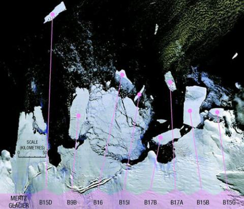
Once in a life time event.... http://www.leparisien.fr/international/ale...2009-741062.php 11 Dec 09 - A giant iceberg measuring 140 square km (54 square miles) - double the size of either Sydney Harbour or Manhattan - is headed for Australia. The Bureau of Meteorology said the once-in-a-century cliff of ice broke off from Antarctica nearly 10 years ago. Known as B17B, the mammoth chunk of ice - 12 miles long and five miles wide - is about 1,700 km (1,056 miles) off Australia's southwest coast, according to the country's Antarctic Division. "B17B is a very significant one in that it has drifted so far north while still largely intact," said Australian Antarctic Division glaciologist Dr Neal Young, who spotted the slab using satellite images taken by NASA and the European Space Agency. Dr Young said if the iceberg on its northward path, it would eventually break up into hundreds of smaller icebergs. The smaller icebergs created when the larger berg break up could become shipping hazards if they float closer to shore. Australian authorities have issued a shipping alert over the gigantic iceberg. Dr Young said an iceberg the size of B17B had not been seen so far north since the days when 19th century clipper ships plied the trade route between Britain and Australia. Originally three times its current size, the iceberg broke off Antarctica's Ross Ice Shelf in 2000 along with several others, and has since traveled thousands of miles and a third of the way around Antarctica. It stayed completely still in one spot for about five years, but is now on the move again. APRESSE.....
-
Observations tempête du 9-10 décembre 2009
iceberg a répondu à un(e) topic de Trapper dans Discussions générales
Current - Courant - Observation : 19:18PM EST DEC 9, 2009. Place: Montreal-East Obs: SNOW GRAINS WITH LIGHT SNOW Temp: -2.2c Dew: -3.0c Wchill: -6.3c Hum: 94% Wind: 11.2km/h SE (GENTLE BREEZE) Gust: 14.8km/h Pres: 987.2 hpa (F) snow: 24cm PAST 15 HOURS Clbase: 337 FEET WEATHER INFO: THE PEAK WIND GUST SO FAR TODAY WAS 47.9 KM/H AT 14:43PM. -
DISCUSSIONS PRÉVISIONS du 14 au 20 déc 2009
iceberg a répondu à un(e) topic de Trapper dans Discussions générales
Tempête de reve.... the dream storm....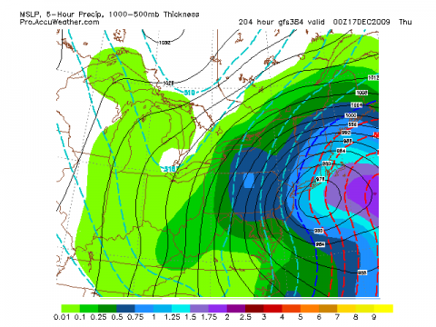
-
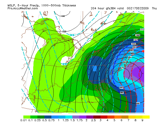
PRÉVISIONS SYSTÈME DES 9 ET 10 DÉC. 09
iceberg a répondu à un(e) topic de manou63 dans Discussions générales
I just want to mention that a few private weather forcasters are predicting only 20 cm of snow for the Montreal area.Its all possible as the system is a fast moving one and will have the energy transfer to the second low moving toward new brunswick. TIME WILL TELL... -
PRÉVISIONS SYSTÈME DES 9 ET 10 DÉC. 09
iceberg a répondu à un(e) topic de manou63 dans Discussions générales
I WIL GIVE IT A SHOT ON THE SEASONS 1ST SNOWSTORM. This will only be for the Montreal area..... I belive as low pressure systen tracks south of the great lakes and takes a course that wil have it a tad west of the Montreal area. The snow amounts will be around the 15 cm mark if no liquid precip adds to the total it may reach 18 cm.The warm air aloft will be lifted more to the east then north because of the dynamics of the low pressure system . A very windy storm for us. I will not go into the details of the storm system but it will be a good storm for the season to start off . -
This is not a rare event not to have a min of -10c in Nov. November of 1948 had no temp of -10c or below and the first -10c was in December 20th 1948 the low was -11.1c. Nothing to get excited about.... And im sure i could find more years like that. I believe that in the 1820s there were lots of years in that period that were very warm for Southern Quebec. AND THIS IS FOR MONTREAL ,QUEBEC.
-
Radio WR-300 et Environnement Canada
iceberg a répondu à un(e) topic de Dal dans Discussions générales
THIS IS THE CODE NEAREST TO YOUR AREA. Clinton 036019 Burlington, VT 162.400 KIG60 500 IVE READ THE MANUAL AND I THINK IT WILL ANSWER YOUR QUESTION... I WOULD PHONE THEM AND ASK THEM DIRECTLY... Phone: (816) 241-8500 http://www.midlandradio.com/Resource_/Owne.../102/WR-300.pdf -
Observations du 9 au 15 novembre 09
iceberg a répondu à un(e) topic de Pierre dans Discussions générales
Current - Courant - Observation : 21:50PM EST NOV 9, 2009. Place: Montreal-East Obs: a few clouds Temp: 16.1c Dew: 9.8c Wchill: 16.1c Hum: 67% Wind: 12.2km/h N (LIGHT BREEZE) Gust: 17.3km/h Pres: 1019.6 hpa ® Rain: NIL Clbase: 2571 FEET WEATHER NOTES: MAX TEMP TODAY 20.0C REACHED AT 14:26PM HIGH WIND GUST OF 42.8KM/H AT 18:33PM -
IDA IS STILL A DANGEROUS STORM..... A DANGEROUS STORM TIDE WILL RAISE WATER LEVELS BY AS MUCH AS 3 TO 5 FEET ABOVE GROUND LEVEL ALONG THE COAST NEAR AND TO THE EAST OF WHERE THE CENTER MAKES LANDFALL...AS WELL AS IN AREAS OF ONSHORE FLOW IN SOUTHEASTERN LOUISIANA. NEAR THE COAST...THE SURGE WILL BE ACCOMPANIED BY LARGE AND DESTRUCTIVE WAVES. IDA IS MOVING TOWARD THE NORTH NEAR 18 MPH...30 KM/HR. A REDUCTION IN FORWARD SPEED IS EXPECTED OVERNIGHT. ON THE FORECAST TRACK... THE CENTER OF IDA SHOULD REACH THE NORTHERN GULF COAST TONIGHT. AFTER LANDFALL...IDA IS EXPECTED TO TURN EASTWARD ON TUESDAY. WITH ONE INTERESTING EXCEPTION...THE LATEST REPORTS FROM AN AIR FORCE RESERVE UNIT RECONNAISSANCE AIRCRAFT INDICATE THAT IDA REMAINS JUST BELOW HURRICANE STRENGTH. A CONVECTIVE BURST THAT BEGAN A FEW HOURS AGO HAS TEMPORARILY HALTED THE WEAKENING TREND.
-
OBSERVATIONS 19 AU 25 OCTOBRE 09
iceberg a répondu à un(e) topic de Pierre dans Discussions générales
Current - Courant - Observation : 20:14PM EST OCT 23, 2009. Place: Montreal-East Obs: ICE PELLETS MIXED WITH LIGHT DRIZZLE Temp: 1.9.c Dew: -1.0c Wchill: -1.5c Hum: 81% Wind: 24.5km/h SE (LIGHT BREEZE) Gust: 24.5km/h Pres: 1022.8 hpa (F) Rain: 0.0mm last 12HRS Clbase: 1124 FEET -
OBSERVATIONS 19 AU 25 OCTOBRE 09
iceberg a répondu à un(e) topic de Pierre dans Discussions générales
Current - Courant - Observation : 17:05PM EST OCT 22, 2009. Place: Montreal-East Obs: SNOW Temp: 1.1.c Dew: -0.2c Wchill: -3.3c Hum: 91% Wind: 24.5km/h n (LIGHT BREEZE) Gust: 26.3km/h Pres: 1015.3 hpa ® Rain: 13.5mm last 18HRS Clbase: 531 FEET -
Observations 12 au 18 octobre 2009
iceberg a répondu à un(e) topic de Pierre dans Discussions générales
Current - Courant - Observation : 17:00PM EST OCT 14, 2009. Place: Montreal-East Obs: Light snow showers Temp: 4.0.c Hudex: NIL Dew: -4.4c Wchill: 4.0c Hum: 55% Wind: 2.5km/h n (LIGHT AIR) Gust: 5.0km/h Pres: 1024.8 hpa (F) Rain: 0.3mm last 24HRS Clbase: 3453 FEET -
Observations 12 au 18 octobre 2009
iceberg a répondu à un(e) topic de Pierre dans Discussions générales
RECORD LOW TEMPS... FOR OCT 12 2009. Location Today Record Year Period of Min Min Record Banff -22.0 -14.0 2002 1893-2009 Rocky Mountain House -19.0 -12.1 2002 1917-2009 Cold Lake - 8.1 - 6.2 2002 1953-2009 Red Deer -14.7 -11.1 1961 1904-2009 Lethbridge -16.7 -13.5 2002 1886-2009 Calgary -16.1 -13.3 1928 1884-2009 Pincher Creek -19.5 -12.8 2002 1893-2009 Sundre -21.0 -13.6 2002 1985-2009 Waterton Park Gate -24.3 -16.6 2002 1966-2009 http://www.weatheroffice.gc.ca/warnings/SW..._e.html?prov=ab -
Observations 1 er au 7 octobre 09
iceberg a répondu à un(e) topic de Pierre dans Discussions générales
I was in Vimont today and a thunderstorm popped up at 11:28am and at 12:30 pm with heavy showers but no lightning was too be seen. -
THIS IS REALLY RARE TO HAVE SNOW IN SPRING TIME IN NEW ZEALAND THIS FAR NORTH... http://www.nzherald.co.nz/nz/news/article....jectid=10601501
-
devinez la date de la première neige pour MONTRÉAL
iceberg a répondu à un(e) topic de castor028 dans Discussions générales
31 Octobre, Halloween -
Observations 23 au 30 septembre 09
iceberg a répondu à un(e) topic de Pierre dans Discussions générales
High wind gust of 61.2km/h was measured at 18:29pm at the Montreal East Station. -
Observations 23 au 30 septembre 09
iceberg a répondu à un(e) topic de Pierre dans Discussions générales
Current - Courant - Observation : 22:55PM EST SEPT 27, 2009. Place: Montreal-East Obs: Light Rain Temp: 13.9c Hudex: NIL Dew: 12.9c Wchill: 13.9c Hum: 94% Wind: 11.2km/h E (LIGHT BREEZE) Gust: 13.3km/h Pres: 999.4 hpa (F) Rain: 14.4mm last 24HRS Clbase: 390 FEET -
Current - Courant - Observation : 9:58PM EST SEPT 17, 2009. Place: Montreal-East Obs: CLEAR Temp: 16.9c Hudex: NIL Dew: 11.0c Wchill: 16.9c Hum: 69% Wind: 11.2km/h WNW (LIGHT BREEZE) Gust: 14.8km/h Pres: 1016.8 hpa (F) Rain: NIL last 24HRS Clbase: 2397 FEET WEATHER NOTES: THE STATION IN MONTREAL-EAST BROKE THE RECORD FOR CONSECUTIVE DAYS WITHOUT RAIN AT 18. THE OLD RECORD WAS SET IN AUGUST OF 1957 AT 17. THE LAST TIME THE STATION REPORTED RAIN WAS ON THE 30TH OF AUGUST.
-
The El Nino of 1918-19 was a strong one. Also that winter season was a cold one in North America. Ohh and one more, the spanish flu or h1n1 as we know it today killed millions. Now the million dollar question is will it strike this winter season with a full force, we dont know yet but now there might be a link with a strong El Nino and the flu pandemic.. yet im still forcasting that the El Nino of this coming winter will wane down as the winter season advances... MY WINTER FORCAST WILL BE OUT IN LATE OCTOBER...... The link on this report... http://geosciences.tamu.edu/communications...nd-flu-pandemic