iceberg
-
Compteur de contenus
1 349 -
Inscription
-
Dernière visite
-
Jours gagnés
47
Type de contenu
Profils
Forums
Events
Gallery
Tout ce qui a été posté par iceberg
-
Tremblement de terre majeur dans les Caraïbes
iceberg a répondu à un(e) topic de Regg001 dans Discussions générales
Voici un lien sur le tremblement de terre .....les plus récents.... http://earthquake.usgs.gov/earthquakes/rec...quakes_all.html -
Observations du 5 au 10 janvier 10
iceberg a répondu à un(e) topic de Pierre dans Discussions générales
C'est la station 92.1 radio FM. Bien sûr c'est une erreur . -
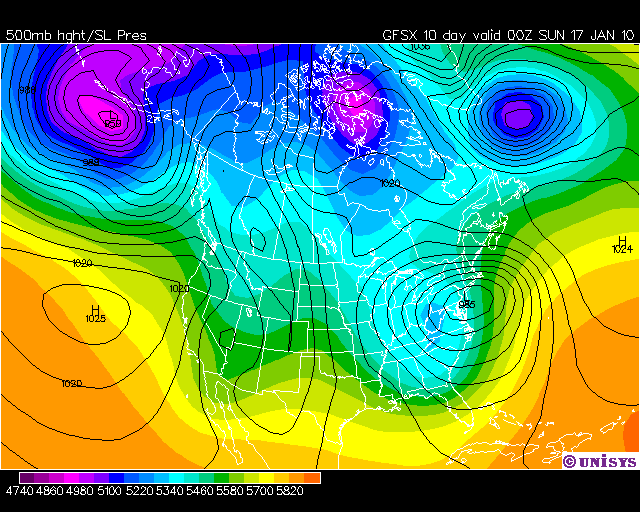
DISCUSSIONS ET PRÉVISIONS DU 11 AU 17 JANVIER 10
iceberg a répondu à un(e) topic de Pierre dans Discussions générales
Jan 17-18 SERA NEIGEUX POUR LE SUD DU QUEBEC COMME DIT LE GFSX A JOUR 10.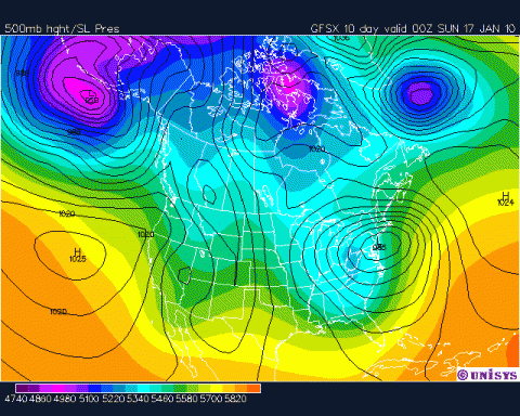
-
Winter of 2009-2010 Could Be Worst in a Quarter Ce
iceberg a répondu à un(e) topic de wingei dans Discussions générales
Voici quelques dates de grande froid en Floride. FORT Barrancas à Pensacola HARBOR-12C MIN 16 février 1823. Tué tous les arbres.JACKONVILLE, FLORIDE-14C MIN.300, 000 $ PERTE Au Citrus FRUITS.TALLAHASSE, FLORIDE-19C 13 février 1899.RECORD BASSE POUR FLORIDA.TAMPA BAY AIRPORT FLORIDA-8C 1963.KEY West, Floride +2 C FEB, 1835 et 5C en janvier 1886.Tous des minimum.Février 1835 a été le plus froid en Floride avec la moitié de l'État recouverte en neige. -
DISCUSSIONS PRÉVISIONS du 4 au 10 jan 2010
iceberg a répondu à un(e) topic de Trapper dans Discussions générales
Nous pourrions encore avoir le même senerio comme ce week-end pour la fin de cette semaine.De la neige avec du vent. ESPECIALLY FOR NORTHERN ZONES/HIR ELEVATIONS. QPF TO BE LGT BASED ON DRY AIRMASS. SFC RIDGE DOES NOSE INTO SOUTHERN QUEBEC/NORTHERN NEW ENGLAND ON FRI/FRI NGT. THIS WILL AID PORTIONS OF THE NORTHEAST...AS MDLS BRING SFC LOW OFF THE SE COAST AND RIGHT NEAR THE 40/70 BENCHMARK. UPPER LOW DIGGING OUT OF THE GREAT LKS WILL HELP TO GRAB SFC MOISTURE THROWING IT INLAND...SIMILAR TO CURRENT STORM. DIFFERENCE HERE AT THIS TIME IN MDLS IS SFC LOW FAST MVG AND DOES PUSH OUT TO SEA. REMAINING UPPER LOW WILL MV UP INTO THE CANADIAN MARITIMES GOING INTO NEXT WEEKEND. SO OVERALL FOR NOW WILL HIGHLIGHT CHANCE POPS FOR CWA...TAPERING DOWN TO SL CHANCE IN NORTHERN ZONES. THIS MAY HAVE TO WATCHED OVER THE NEXT COUPLE OF DAYS AS ANY SHIFT NORTH WILL BRING LARGER SWATH OF MOISTURE OVER THE NORTH COUNTRY FOR A POTENTIAL LARGER AMT OF SNOW. TEMPS GO BLW NORMAL GOING INTO THE UPCOMING WEEKEN NOAA............. -
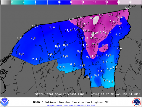
OBSERVATIONS DU 1 ER AU 4 JANVIER 2010
iceberg a répondu à un(e) topic de Pierre dans Discussions générales
Burlington a reçu 32,9'' (ou 83,6 CM), leur plus grosse accumulation de neige (pour un événement) de l'histoire! Effet plutôt local, mais quand même! Source : http://www.weather.gov/view/prodsByState.p...prodtype=public RECORD REPORT NATIONAL WEATHER SERVICE BURLINGTON VT 1244 AM EST SUN JAN 3 2010 ...RECORD DAILY MAXIMUM SNOWFALL SET AT BURLINGTON VERMONT... A RECORD SNOWFALL OF 19 INCHES FELL AT THE BURLINGTON INTERNATIONAL AIRPORT YESTERDAY, JANUARY 2. THIS BREAKS THE OLD RECORD OF 7.5 INCHES SET ON THAT DATE IN 1947. POUR HIER... -
OBSERVATIONS DU 1 ER AU 4 JANVIER 2010
iceberg a répondu à un(e) topic de Pierre dans Discussions générales
Je pense que nous sommes en Janvier 2010... -
OBSERVATIONS DU 1 ER AU 4 JANVIER 2010
iceberg a répondu à un(e) topic de Pierre dans Discussions générales
OBSERVATION POUR MA STATION A MONTREAL EST...... AVEC DE LA FAIBLE NEIGE..... http://pages.videotron.com/slmeteo/index.htm -
Neige totale Prévisions Pour New York et Vermont..... UNE HAUSSE POUR LES CM DE NEIGE.LA BASSE PRESSION ET PLUS A L`OUEST.
-
MERCI REGG !!!.....TRES BON SITE
-
Bonjour les membres, voici un logiciel de Cumulus sur SANDAYSOFT.Tu pu télécharger ce logiciel, dans votre station météo. Il ya quelques membres dans ce forum qui sont deja membres. VOICI LE LIEN POUR LE SITE... http://sandaysoft.com/products/cumulus ET VOICI LE LIEN POUR LES MEMBRES DE SANDAYSOFT http://sandaysoft.com/maps/cumulus-map.php VOICI MON LIEN DANS SANDAYSOFT...... http://pages.videotron.com/slmeteo/index.htm ET VOICI LE LIEN POUR Télécharger CA EN FRANCAIS..... http://sandaysoft.com/downloads
-
OBSERVATIONS DU 1 ER AU 4 JANVIER 2010
iceberg a répondu à un(e) topic de Pierre dans Discussions générales
OBSERVATION.... LIEN POUR MTL EST.... http://pages.videotron.com/slmeteo/index.htm -
En regardant EC site pur la région de Montréal et je ne vois que 0C pour une température max pour dimanche.
-
Observations des 26 et 27 décembre 2009
iceberg a répondu à un(e) topic de Mistral21 dans Discussions générales
FAIBLE NEIGE EN CE MOMENT..... OBSERVATION..... http://pages.videotron.com/slmeteo/index.htm -
Observations du 21 au 27 décembre 2009
iceberg a répondu à un(e) topic de Pierre dans Discussions générales
OBSERVATION...... LIEN.... http://pages.videotron.com/slmeteo/index.htm -
SUPER BLIZZARD 2009 I-95 CORRIDOR
iceberg a répondu à un(e) topic de iceberg dans Discussions générales
DAVE TU A MIS LA MAIN SUR LE PIC. REAJEAN A LA TETE DUR...... -
SUPER BLIZZARD 2009 I-95 CORRIDOR
iceberg a répondu à un(e) topic de iceberg dans Discussions générales
COMME REGG A DIT DU 15 CM GROS MAX POUR NEW YORK... OUF I THINK HE IS DREAMING DANS LES NUAGES... LISTEN REGG YOU ARE WRONG AND I KNOW WHAT YOU MEANT SO DONT TRY TO COVER YOUR MISTAKE AND I SPEAK BETTER THEN YOU IN FRENCH .NOW TELL ME WHERE THE RAIN IS I SEE IT IN THE OCEAN NOT NEAR LAND. AND AS FOR THE COASTAL CITIES TELL ME WHICH ONES AND DONT TELL ME SOME RAG TOWNS. JOYEUX NOEL REGG...... -
SUPER BLIZZARD 2009 I-95 CORRIDOR
iceberg a répondu à un(e) topic de iceberg dans Discussions générales
COMME REGG A DIT DU 15 CM GROS MAX POUR NEW YORK... OUF I THINK HE IS DREAMING DANS LES NUAGES... -
SUPER BLIZZARD 2009 I-95 CORRIDOR
iceberg a répondu à un(e) topic de iceberg dans Discussions générales
So once again this is a powerful storm with 45 mile an hour gusts .. CNN is reporting blizzard whiteouts in the Washington area. I dont know where regg got his information but its all BULL information on what he is saying ... This is the latest map of where the heaviest snow should line up. The Interstate 95 corridor from Boston to Washington D.C. will be hit hard with a foot of snow today. From 12 to 18 inches of snow are forecast for Philadelphia. The heaviest snow will end up being across southern New Jersey, the northern Delmarva and into northeastern Virginia, where up to 2 feet could accumulate. This area will be hit with white-out conditions and huge snow drifts. New York City is expected to be buried by a foot of snow. Amounts will be smaller, 3-6 inches to the north and west of 287. Long Island will have 1-2 feet of snow! From 6 to 12 inches of snow are in store for Boston. Snow will stretch into the Ohio Valley from this system, but amounts will drop off dramatically as you head westward. Travel today from the mountains eastward will be difficult if not impossible.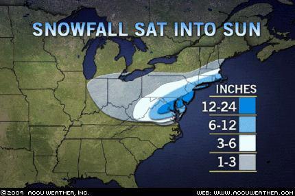
-
SUPER BLIZZARD 2009 I-95 CORRIDOR
iceberg a répondu à un(e) topic de iceberg dans Discussions générales
THIS IS THE LINK FOR THE WARNING AREAS..... http://www.erh.noaa.gov/phi/ -
SUPER BLIZZARD 2009 I-95 CORRIDOR
iceberg a répondu à un(e) topic de iceberg dans Discussions générales
One example is the triple (3) storms of december 1839. In 14 days no less then 8 major cyclonicdisturbances crossed the north eastern sates. 150 lives lost all in all about 8 to 12 feet of snow measured in 14 days.Montreal also did not fare well on this as 6 feet of snow was measured in the 2 weeks with very high winds. But 3 storms were the big hits. The first one was Dec 15-16. The second was Dec 22-23 and the last and worst one was Dec 27-28. -
SUPER BLIZZARD 2009 I-95 CORRIDOR
iceberg a répondu à un(e) topic de iceberg dans Discussions générales
The 1960 December storm was a secondary in redevelopment characteristics. The lowest central sea level pressure analyzed was 960mb.The duration of deepening was 42 hours and amount of deepening was 52 hours.The duration of the primary low following formation of secondary low center was 15 hours. This storm has the same characteristics of the one now 2009 . -
SUPER BLIZZARD 2009 I-95 CORRIDOR
iceberg a répondu à un(e) topic de iceberg dans Discussions générales
This storm is not a monster storm or storm of the century. Its a big enough storm to cause problems for motorists. The storms of today do not compare with storms of the 1800s where it would have been in feet so rejean to not get to hyper on this storm. To me a big storm is high winds and 2 feet of snow.... now thats me.... -
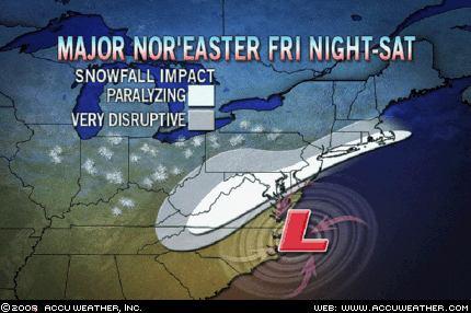
IM OPENING THIS TOPIC ON THE MAJOR STORM THAT WILL IMPACT THE MIDDLE ATLANTIC STATES AND OF COURSE NEW YORK AND BOSTON. I WILL BE GIVING OUT MORE INFORMATION ON PAST BLIZZARDS IN THE MONTH OF DECEMBER FOR THE REGION. ONE OF THEM IS THE BLIZZARD OF DECEMBER 10-13 1960.... WASHINGTON DC...22CM BALTIMORE....36CM PHILADELPHIA...37CM NEW YORK, NEW YORK......44CM BOSTON...33CM TRENTON...42CM NEWARK...52CM THIS INFORMATION ON TOTAL SNOWFALLS IS BROUGHT TO YOU BY AMS... Make no mistake, folks. If you live anywhere from Virginia to southern New England, you are staring right down the barrel of a major snowstorm. This will be one of those classic nor'easters that can dump an inch or more of snow per hour. The belt of heaviest snow, and absolute worst travel conditions, will extend from Virginia through northeastern Maryland and New Jersey to southeastern New England. This includes the major cities of Washington, Baltimore, Philadelphia and Boston. Basically, the whole I-95 corridor is going to turn into a real nightmare for highway travelers. Snowfall totals will be less the farther north you are, but poor travel can be expected to the mountains of central Pennsylvania. Upstate New York and central and northern New England will miss out on this one. Again, this will become one of those memorable winter storms, and it's going to be quite difficult to get around. BY ACCUWEATHER
-
Observations du 16 au 20 décembre 2009
iceberg a répondu à un(e) topic de Pierre dans Discussions générales
Current - Courant - Observation : 06:03AM EST DEC 17, 2009. Place: Montreal-East Obs: CLEAR Temp: -19.5c Dew: -24.0c Wchill: -27.4c Hum: 66% Wind: 13.3km/h SSE (LIGHT BREEZE) Gust: 20.9km/h Pres: 1026.4 hpa ® snow: 0.7CM LAST 24 HOURS Clbase: 1883 FEET