meteomarc
-
Compteur de contenus
974 -
Inscription
-
Dernière visite
-
Jours gagnés
3
Type de contenu
Profils
Forums
Events
Gallery
Tout ce qui a été posté par meteomarc
-
Comme Regg le mentionnait plus tôt, le front froid a été TRÈS actif hier...une tornade a fait 11 morts en plus d'une centaine de blessés hier dans l'Illinois ...Pendant ce temps, de la neige abondante est sur le point d'affecter les régions du nord du Québec, 25 cm et AW en evance même un quarataine pour la région de Fermont
-
meso si tu es melanger...1 mp/h = 1.6 km/h
-
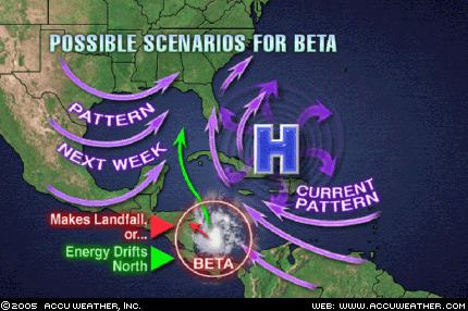
Beta a touché terre a 6 heure ce matin(dimanche)...cette nuit, l'ouragan a atteint le seuil de catégorie 3, avec des vents de 115 mph...nous sommes maintenant a 7 ouragan majeur depuis le début de la saison, le record est de 8...un autre record possible?...possible oui...mais nous sommes tout de même a la fin octobre!
-
Les spécialistes de Accuweather disent que Beta pourrait interagir avec une vague tropicale qui se trouve présentement dans la mer des caraibes et se retrouver dans le golf du Mexique la semaine prochaine ...mais le scénario le plus probable reste que Beta frappe la côte du Nicaragua!

-
D'après moi BETA ne restera pas assez longtemps au-dessus de l'eau pour devenir d'une très grande force...2 ou 3 p-t...mais sait-on jamais les experts se sont faits déjouer à maintes et maintes reprises cette année on a qu'à penser a Wilma Rita et Katrina!
-
Chez moi a Granby on a eu droit a grosso modo 7-10 cm de neige très très lourde et mouillé...Ma maison a manqué d'électricité cette nuit et ce matin...C'était le cas également de plusieurs de mes amis...En plus la neige tombait intenséement pendant 4 heures hier soir mais elle était fondante...tk pas si pire pour une premièere neige!
-
A Granby également il neige a plein ciel depuis environ 5h ce soir et ca tombe assez fortement...On en est environ 2 cm a cause que au début c'était fondant...mais si ca tombe comme cela toute la nuit il y a possibilité d'atteindre le 10 cm d'après moi!
-
Ici il fait présentement 0 degré!
-
Ici a Granby ca fait un peu plus d'une heure qu'il neige...sauf que c'est fondant le sol est trop mouillé...mais je prévois me réveiller avec un petit tapis blanc !
-

Scénario potentiellement catastrophique ?!
meteomarc a répondu à un(e) topic de Pierre dans Discussions générales
MM prévoit toutefois 15-25 cm de neige sur la beauce eet l'estrie! -
Scénario potentiellement catastrophique ?!
meteomarc a répondu à un(e) topic de Pierre dans Discussions générales
En effet Meso...Pour Granby, EC dit une dizaine de cm...MM ne mentionne même plus la neige si ce n'est que quelques flocons fondants...Bizzares vu qu'on se trouve dans le début des précipitations... -
Scénario potentiellement catastrophique ?!
meteomarc a répondu à un(e) topic de Pierre dans Discussions générales
Meteomedia et EC semblent se plier a l'idée de la neige...du moins pour une partie de la montérégie...pour demain soir MM prévoit un mélange a part égale pour ma ville(Granby)et carrément de la pluie pour Montreal et Sherbrooke... N-B: Ceci ne comporte pas les prévisions pour la nuit... -
Scénario potentiellement catastrophique ?!
meteomarc a répondu à un(e) topic de Pierre dans Discussions générales
Patito concernant ta carte sur les types de précipitaions...je ne comprend pas qu'il n'y ait pas de zone de mélange entre la zone de pluie et celle de neige... -
Scénario potentiellement catastrophique ?!
meteomarc a répondu à un(e) topic de Pierre dans Discussions générales
J'ai une question comme ca...Disons que Wilma est une tempête tropicale lors de sa fusion avec Alpha...est-ce que une combinaison comme celle-la pourrait ramener Wilma a la catégorie 1? -
Scénario potentiellement catastrophique ?!
meteomarc a répondu à un(e) topic de Pierre dans Discussions générales
Regardez le MRF...il semble remonter Wilma sur le maine!
-
Scénario potentiellement catastrophique ?!
meteomarc a répondu à un(e) topic de Pierre dans Discussions générales
Eh bien qui aurait pu dire il ya quelques jours que deux tempetes tropicales allaient se fusionner et que lon aurait peut-etre droit a une tempete de neige mardi soir!?!...La meteo est bien capricieuse par moment...et cest ce qui fait quelle est si plaisante a prevoir! -
La tempête Alpha en formation...?
meteomarc a répondu à un(e) topic de Pierre dans Discussions générales
Ca y'est cette apres-midi cette dépression est maintenant tropicale et devrait devenir une tempete tropicale d'ic cette nuit! Alpha s'en vient! -
La tempête Alpha en formation...?
meteomarc a répondu à un(e) topic de Pierre dans Discussions générales
Je lisais sur Accuweather que cette tropical wave donnait des rafales de 35 mph et plus a beaucoup d'endroits dans les antilles...Et cette vague est assez imposante...donc en effet ca regarde bien pour alpha! -
Scénario potentiellement catastrophique ?!
meteomarc a répondu à un(e) topic de Pierre dans Discussions générales
Le NHC prévoit que Wilma aura des vents de 165 mph quand elle touchera terre! Si Stan a réussit a ravager le Mexique...Alors que cet ouragan n'en était en fait pas un(tempête tropicale kan elle a toucher la péninsule si je me souviens bien)...Imaginez ce que ferait un ouragan de catégorie 5 comme dommage! CA-TA-STRO-PHIQUE!!! -
Scénario potentiellement catastrophique ?!
meteomarc a répondu à un(e) topic de Pierre dans Discussions générales
A 5 heures ce soir wilma semble se réintensifier...elle ki est maintenant ouragan de catégorie 4...avec des vents soutenus de 150 mph...si je dis vrai ca serait catastrophique car elle se réintensifierait juste su le bord des côtes du yucatan... -
Scénario potentiellement catastrophique ?!
meteomarc a répondu à un(e) topic de Pierre dans Discussions générales
Hey Hailstorm jai un autre record a ajouter a tout ca...Wilma est l'ouragan, dans tout lhistoire de latlantique, dont l'intensification a été la plus rapide!...tout ça c'est fou on est a la mi-octobre!!! -
Les premiers flocons moi je les voient plutot entre le 22 et le 26 octobre, les températures de nuit permettront les flocons et entre ces dates on annonce des précipitation avec des températures de jour entre 5 et 10 et de nuit de 0 environ.
-
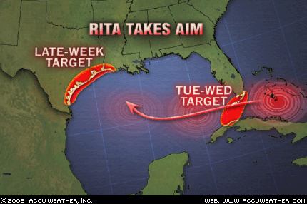
As of 5:00 PM EDT Wednesday, Rita is packing sustained winds of 165 mph with gusts to 185 mph; this makes Rita a category 5 hurricane. This is the season's second catastrophic hurricane. As of 5:00 PM EDT, Rita was centered near 24.4 north and 86.8 west. This places Rita 700 miles east-southeast of Corpus Christi, or 600 miles east southeast of Galveston Texas. The minimum central pressure has fallen to 914 millibars (26.99 inches of mercury). Rita was moving to the west at 13 mph. Hurricane-force winds extend outward up to 70 miles, and tropical storm-force winds extend outward up to 175 miles from the center of circulation. Given that Rita will continue to intensify the wind field will probably expand further over the next 24 hours Patito je ne crois pas que Rita restera catégorie 5 jusqu'a toucher terre...louragan est présentement dans la partie la plus propice au dévellopement et plus elle se rapprochera de la cote, plus elle diminura en intensité...sensiblement la meme chose qui est arriver a katrina.
-
L'action reprend dans les tropiques
meteomarc a répondu à un(e) topic de Mistral21 dans Discussions générales
Hurricane Rita will gain strength when she passes through the Florida Straits Tuesday and Wednesday. The storm's first target will be the Florida Keys where there will be massive waves, torrential rain and deafening winds. During midweek, the storm will enter the virgin waters of the central Gulf of Mexico where sea surface temperatures are at 85 degrees or higher. That will provide the storm with all the energy it needs to become a category 4 hurricane if she hasn't done so already. Joe Bastardi, one of AccuWeather's hurricane experts, made the comment that the storm could explosively develop and be a category 3 hurricane by the time it passes Key West Tuesday night. After the Keys, the next target will be the western Gulf Coast. The storm is still over 1200 miles away from that area, so we cannot provide precise information about that landfall just yet. Just know it is going to occur somewhere between northern Mexico and southwestern Louisiana late this week, and wherever it happens the situation will be serious.
-
L'action reprend dans les tropiques
meteomarc a répondu à un(e) topic de Mistral21 dans Discussions générales
Noaa et accuweather prévoient pour le moment que Rita deviendra un ouragan majeur assez rapidement, même que l'ouragan serait déja catégorie 2 dans les keys!...elle est présentement en dévellopement assez rapide et atteignera le seuil d'ouragan ce soir!...Pourrait-elle devenir même plus forte que Katrina étant donné le faite qu'elle sera plus forte en entrant dans le golfe et qu'elle aurait les conditions assez semblables a celles de Katrina?...En tout cas pour l'instant la tempête tropicale semble destinée a atterir entre le nord du mexique et la louisiane(oui le risque est la )...tk situation assez intéressante et apeurante pour les gens des keys et du golfe!