


meteomarc
-
Compteur de contenus
971 -
Inscription
-
Dernière visite
-
Jours gagnés
3
Type de contenu
Profils
Forums
Events
Gallery
Tout ce qui a été posté par meteomarc
-

Bye Bye Dennis...Bonjour Emily!
meteomarc a répondu à un(e) topic de Hurry dans Discussions générales
Tropical Storm Emily approaching the Lesser Antilles.. A HURRICANE WARNING IS IN EFFECT FOR TOBAGO...GRENADA... THE GRENADINES...ST. VINCENT...AND ST. LUCIA. A TROPICAL STORM WARNING AND A HURRICANE WATCH ARE IN EFFECT FOR TRINIDAD. A TROPICAL STORM WARNING IS IN EFFECT FOR BARBADOS. A TROPICAL STORM WARNING IS ALSO IN EFFECT FOR A PORTION OF THE NORTHERN COAST OF VENEZUELA...FROM PEDERNALES WESTWARD TO CUMANA...INCLUDING ISLA MARGARITA. A TROPICAL STORM WATCH IS IN EFFECT FOR MARTINIQUE. Tropical Storm Emily, as of 8 a.m. EDT, was centered at 11.3 north, 57.2 west, or about 200 miles southeast of Barbados in the Lesser Antilles. The estimated central pressure is 997 millibars (29.44 inches). Maximum sustained winds are estimated at 60 mph with gusts to 70 mph. It is moving toward the west at 20 mph and is expected to turn slight north of west during the next 24 hours. Once Emily moves closer to the Lesser Antilles, it will be in a more favorable environment. Shear remains low, average surface pressures in the area remain low and water temperatures remain high. So, all the necessary ingredients for intensification are in place. We believe that Emily will track across the Lesser Antilles early tonight, and strengthen to hurricane status in the eastern Caribbean late tonight. It should take a track to the south of Hispaniola Friday and Friday night and is on a course that will take it south of Jamaica Saturday and Saturday night. Emily has the potential to strengthen into a Category 3 hurricane, especially when it gets into the western Caribbean, well away from the South American coastline. Over the next couple of days, how much the storm intensifies will be determined by how close it tracks to Tobago, Trinidad, and the coast of South of America. Obviously, interaction with land would disrupt the intensification process. The large high pressure area over northern Florida is stronger now than what it was when Dennis was moving into the Gulf. So, it could be that this Atlantic ridge will be strong enough to guide Emily more westward, toward the Yucatan and even Central America. A tropical wave in the eastern Atlantic, along 33 west, south of 17 north, features a surface low near or just south of 15 north. This wave has a large envelope of clouds extending northward. This wave resembles the cloud pattern that Dennis had when it was in this same area, will certainly be watched for intensification. Elsewhere in the Tropical Atlantic, a tropical wave along 40 west, south of 16 north has weakened since it is so close to Emily's circulation. So, it is doubtful that this feature will organize anytime soon. The tropical wave in the westernmost Caribbean is along 85 west, south of 18 north, moving westward into Central America. -
Bye Bye Dennis...Bonjour Emily!
meteomarc a répondu à un(e) topic de Hurry dans Discussions générales
Article de AW Tropical Storm Emily, now in the west-central Atlantic, is taking aim on the Windward Islands. It continues to gather strength, and this trend should continue through Wednesday. Upper-level winds are fairly light and are generally from west to east in the area where Emily is headed. This means that there is only weak shear; a favorable situation for any tropical system. Emily is expected to be nearing hurricane strength by the time it reaches the Windward Islands later Wednesday, and with overall conditions still quite favorable, Emily could be a major hurricane by the time it reaches the central Caribbean. should remain in a fairly westerly course the next couple of days as an area of high pressure in the upper levels of the atmosphere will remain to its north. This will keep winds at the steering level blowing from east to west. Emily should roar across the central Lesser Antilles late Wednesday and then head into the eastern Caribbean Thursday.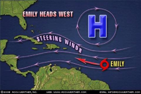
-
Bye Bye Dennis...Bonjour Emily!
meteomarc a répondu à un(e) topic de Hurry dans Discussions générales
J'ai pris ça sur AW...potentiel pour Emily de devenir un Ouragan cette semaine... Hurricane Summary POSTED: July 11, 2005 10:45 p.m. Tropical Storm Emily forms in the central Atlantic and may become a hurricane later in the week. -
Bye Bye Dennis...Bonjour Emily!
meteomarc a répondu à un(e) topic de Hurry dans Discussions générales
Voila, a 11 pm Émily est officielement nommée...La Tempete tropical Émily génère en ce moment des vents de 45 mph...C'est étonnant que cette dépression aille déja passer le seuil de tempete tropical...A 8 heures ce matin, les experts prévoyaient qu'elle passerait le cap de tempete tropicale dans 24 a 48 heures...environ 14 heures plus tard c'est une tempete tropicale... -
chaleur extrêmes dans le Nord-Ouest du Québec
meteomarc a répondu à un(e) topic de Rockabill dans Discussions générales
29,4 a kuujjuarapik était le record pour un 11 juillet...ce n'était pas le record absolu...d'ailleurs est-ce que quelqun a le vrai record absolu pour kuujuarapik? -
chaleur extrêmes dans le Nord-Ouest du Québec
meteomarc a répondu à un(e) topic de Rockabill dans Discussions générales
On annonce 37 degrés celsius a moosonee et le record précédent est de 35.6 degré celsius(j'ai pris cet info sur le site de MM)pour un 11 juillet il sera sans doute battué...mais ma question est quel est le record absolu pour cette région? -
L'ouragan Dennis fonce sur la Jamaique
meteomarc a répondu à un(e) topic de Hurry dans Discussions générales
Dennis va probablament tres tres bientot passer la catégorie 5 ...car l'ouragan génère des vents de 150mph...pour qu'un ouragan soit de catégorie 5, les vents doivent être de plus de 156 mph...et depuis 8 heures ce matin Dennis a augmenter de 15-20mph la vitesse de ses vents soutenus...c'est fou Voici la discussion de AW a 11 ce matin DENNIS REMAINS A DANGEROUS CATEGORY 4 HURRICANE WITH SUSTAINED WINDS OF 150 MPH As of 11:00 a.m. EDT, Hurricane Dennis was centered at 21.4 north, 79.9 west, or about 250 miles south-southeast of Key West, Fla., Maximum sustained winds are 150 mph, with higher gusts. The threshold for a category 5 Hurricane is 156 mph. The estimated central pressure is 938 mb (27.70 inches). Dennis is moving toward the northwest at 15 mph. The aircraft reports, and the satellite shots do seem to indicate more of a west to northwest movement; perhaps this is wobbling effects of the storm. A HURRICANE WARNING IS IN EFFECT FOR CUBA FOR THE PROVINCES OF LA HABANA...CIUDAD DE LA HABANA...MATANZAS... VILLA CLARA... CIENFUEGOS...SANCTI SPIRITUS...CIEGO DE AVILA...CAMAGUEY...LAS TUNAS...GRANMA...SANTIAGO DE CUBA...HOLGUIN AND GUANTANAMO. A HURRICANE WATCH REMAINS IN EFFECT FOR THE ISLE OF YOUTH AND THE PROVINCE OF PINAR DEL RIO. A HURRICANE WARNING IS IN EFFECT FOR THE LOWER FLORIDA KEYS FROM THE SEVEN MILE BRIDGE WESTWARD TO THE DRY TORTUGAS. A TROPICAL STORM WARNING AND A HURRICANE WATCH IS IN EFFECT FOR THE REMAINDER OF THE FLORIDA KEYS...EAST OF THE SEVEN MILE BRIDGE TO OCEAN REEF AND FLORIDA BAY. TROPICAL STORM WARNING FOR CAYMAN BRAC AND LITTLE CAYMAN ISLANDS. ALL WARNINGS HAVE BEEN DISCONTINUED FOR GRAND CAYMAN ISLAND. A TROPICAL STORM WARNING IS IN EFFECT ALONG THE FLORIDA WEST COAST SOUTH OF BONITA BEACH...AND ALONG THE FLORIDA EAST COAST SOUTH OF GOLDEN BEACH. A TROPICAL STORM WATCH IS IN EFFECT ALONG THE FLORIDA WEST COAST NORTH OF BONITA BEACH TO LONGBOAT KEY. Hurricane conditions, including life-threatening storm surge and flash flooding is occurring over central and eastern Cuba; these conditions will shift into western Cuba later today. We expect Dennis to track over the central and western part of Cuba late today, and end up in the southeastern Gulf of Mexico late tonight. All U.S. interests, from the Florida Keys and the Florida west coast, all the way to the Louisiana coast, should closely monitor the progress of this powerful hurricane. As of now, we believe Dennis will head for the central Gulf coast. Current thinking, as far as landfall, is between the mouth of the Mississippi River and Pensacola, Fla. There continues to be different ideas on the exact track. The interaction with the higher terrain of Cuba could alter the hurricane's structure and cause it to react differently to the steering currents. The upper-level high pressure ridge has weakened over Florida and the eastern Gulf while a strong upper-level disturbance is now diving into eastern Texas. This will help to maintain a weakness in the upper-level wind flow over the central Gulf and Dennis will turn northward ahead of this weakness. If the Atlantic high pressure ridge fails to build farther west Dennis could track close to the west coast of Florida. If the upper-level high pressure ridge builds stronger to the west, then Dennis will be diverted more toward Louisiana. As far as intensity changes, Dennis is a Category 4 and should lose at least some strength over Cuba today and tonight. Once the storm moves back over the southeast Gulf it should regain some strength. It has been pointed out by various sources that the depth of very warm water is less over the eastern Gulf of Mexico and this might prevent Dennis from strengthening. However, this is all speculation. As far as effects from Dennis, Cuba will be hit hard through today with torrential, life threatening flooding rainfall. The hurricane's growing circulation size will start to affect South Florida during the day today with increasing breezes and gusty showers. The rain and the wind will increase across the Keys, then into South Florida Friday night. Then, wind swept rain will spread northward over much of the peninsula of Florida during Saturday. Dennis's tropical-storm-force winds extend out to about 140 miles. So, our current projection would put tropical-storm-force winds along the west coast of Florida along with a storm surge of around 3 feet. Rainfall could be heavy enough over Florida to bring 3-5 inches to some places and that could lead to flooding. Tropical Rainstorm Cindy is moving northeastward out of the Chesapeake Bay area. Heavy, flooding rainfall is the main problem with what is left of Cindy; to the right of the track, there can be a few strong to severe thunderstorms. We expect Tropical Rainstorm Cindy will track up into New Jersey this afternoon. Tropical waves to note, even though Dennis is the main show right now: A tropical wave along 41 west, moving west; a tropical wave along 60 west south of 20 north, moving west. -
L'ouragan Dennis fonce sur la Jamaique
meteomarc a répondu à un(e) topic de Hurry dans Discussions générales
Discussion de AW...Vent soutenu de 130mph a 8heures p-m!!!...D'apres moi ca va se rendre a la catégorie 4 avant datteindre cuba DENNIS IS NOW A DANGEROUS CATEGORY 3 HURRICANE WITH SUSTAINED WINDS OF 130 MPH AND IS HEADING FOR CUBA As of 8:00 PM EDT, Hurricane Dennis was centered at 19.4 north, 77.1 west, or about 135 southwest of Guantanamo, Cuba. Maximum sustained winds have increased to 130 mph, with higher gusts. The estimated central pressure is 951 mb (28.08 inches). This makes Dennis a strong Category 3 hurricane. If Dennis increases any more it will become a category 4 hurricane. Dennis is moving toward the northwest at 15 mph. Dennis should remain on this course over the next 24-48 hours. A HURRICANE WARNING IS ISSUED FOR THE LOWER FLORIDA KEYS FROM THE SEVEN MILE BRIDGE WESTWARD TO THE DRY TORTUGAS...AND A TROPICAL STORM WARNING IS ISSUED FOR THE REMAINDER OF THE FLORIDA KEYS...EAST OF THE SEVEN MILE BRIDGE TO OCEAN REEF AND FLORIDA BAY. A HURRICANE WATCH REMAINS IN EFFECT FOR THE FLORIDA KEYS EAST OF THE SEVEN MILE BRIDGE TO OCEAN REEF AND FLORIDA BAY. A HURRICANE WARNING IS IN EFFECT FOR THE PROVINCES OF MATANZAS... VILLA CLARA... CIENFUEGOS...SANCTI SPIRITUS...CIEGO DE AVILA... CAMAGUEY...LAS TUNAS...GRANMA...SANTIAGO DE CUBA...AND GUANTANAMO. A HURRICANE WATCH IS IN EFFECT FOR THE REMAINING PROVINCES OF CUBA INCLUDING THE ISLE OF YOUTH...PINAR DEL RIO...LA HABANA... CIUDAD DE LA HABANA...AND HOLGUIN. Very stormy conditions, including life-threatening flash flooding is imminent for most of central and eastern Cuba. We expect Dennis to track over the central and western part of Cuba Friday afternoon and early Friday night, and end up in the southeastern Gulf of Mexico, later Friday night. All U.S. interests, from the Florida Keys and the Florida west coast, all the way to the Louisiana coast, should closely monitor the progress of this strengthening hurricane. As of now, we believe Dennis will head for the central or eastern Gulf coast. Current thinking is over the western Florida panhandle. However, there continues to be different ideas on the exact track. The interaction with the higher terrain of Cuba could alter the hurricane's structure and cause to to react differently to the steering currents. The upper level high pressure ridge has weakened over Florida and the eastern Gulf while a strong upper level disturbance is now diving into eastern Texas. This will help to maintain a weakness in the upper level wind flow over the central Gulf and Dennis will turn northward ahead of this weakness. If the Atlantic high pressure ridge fails to build further west Dennis could track close to the west coast of Florida. If the upper level high pressure ridge builds stronger to the west the Dennis will be diverted more toward eastern Louisiana. On a historical note, this is the earliest in the Atlantic hurricane season that the "D" named storm has been reached. In no other season, back through the time in which records have been kept, have there been four named storms by this early date. Tropical rainstorm Cindy is located about 80 miles northeast of Asheville North Carolina and is moving northeast at about 20 mph. Heavy, flooding rainfall is the main problem with what is left of Cindy; to the right of the track, there can be a few strong to severe thunderstorms. We think Tropical Rainstorm Cindy will track up through the western Carolinas early tonight, and into Virginia by Friday morning. Tropical waves to note: a wave, or actually a 1014 mb low is centered near 11 north, 20 west; strong thunderstorms are nearby. This is a very large, impressive-looking system in the eastern Atlantic similar to what Dennis looked like about 10 days ago. A tropical wave is along 38 west, south of 20 north, moving west; no strong thunderstorms are associated with this system. A tropical wave is along 54 west, south of 16 north, moving west. -
L'ouragan Dennis fonce sur la Jamaique
meteomarc a répondu à un(e) topic de Hurry dans Discussions générales
Et voila, comme prévue, l'ouragan Dennis a atteint la catégorie 3 depuis 5heures cette apres-midi avant d'atteindre cuba...Elle y fonce maintenant avec des vents destructeurs de plus de 110 mph...Elle perdra un peu de force en survolant Cuba mais la reprendra aussitot rendue dans le golf du Mexique...Elle pourrait atteindre la catégorie 4 avant d'atteindre les cotes américaines mais c loin detre sur...En attendant jespere que les gens de Cuba sont bien a l'abri car ca va brasser!!! -
L'ouragan Dennis fonce sur la Jamaique
meteomarc a répondu à un(e) topic de Hurry dans Discussions générales
En passant, un autre systeme a surveiller...il se détache présentement de la cote Africaine...Si ce systeme survis aux eaux un peu plus fraiches de cette région de l'atlantique, il pourrait peut-etre devenir Emily... -
L'ouragan Dennis fonce sur la Jamaique
meteomarc a répondu à un(e) topic de Hurry dans Discussions générales
J'ai regarder l'image visible de louragan...il commence vrmt a etre bien oraganisé...on peut meme voir loeil sur l'image visible...la jamaique et lest de cuba vont vraiment y gouter ...Je crois meme qu'avec les eaux chaudes du golf du Mexique et l'absence de d'autres bons systemts pres de Dennis, cette ouragan pourrait se retrouver de force 4 selon moi -
Selon le graphique tendance 14 jours de MM, il y aurait effectivement une canicule a partir du 11...le 13 serait la journée la plus chaude et le tout se finirait le 14...
-
Le tonerre de tout a l'heure est maintenant accompagner de flash mais je ne saurais dire si il tombe des éclairs pres de chez moi car des arbres entoures ma maison
-
Méchante cellule a la frontiere, elle se dirige est nord est...tres prometteur pour l'estrie et c'est cette cellulle qui donne du tonerre dans mon secteur, mais le gros se passe au sud...bonne fin d'apres-midi en vue et le début de soirée également!
-
J'habite a granby, c pas si loin de st-hyacinthe ou il y a veille, et depuis quelques minutes le tonerre gronde et il pleut...On verra bien
-
Voici les prévisions de Accuweather pour ma région(granby) cette apres-midi...tres prometteur!!! Tuesday Variable clouds, a few strong thunderstorms High Temperature: 28° C RealFeel®: 31° C Winds: W at 9 kph Wind Gusts: 20 kph Maximum UV: Moderate (4) Thunderstorm Probability: 100% Amount of Precipitation: 1.65 cm Amount of Rain: 1.65 cm Amount of Snow: 0 cm Hours of Precipitation: 4 hrs Hours of Rain: 4 hrs
-
Selon la carte foudre, la cellule orageuse dont tu parles ne donnent plus aucune éclair depuis qu'elle a passé Montréal...je n'ai pas vérifié par contre si elle donnait encore des averses...
-
Géniale les photos en particuler celle de lentonnoir!
-
Alerte de tornade en vigueur pour le sud du manitoba... .M. Of Stanley including Winkler and Morden 9:27 PM CDT Saturday 2 July 2005 Tornado warning for r.M. Of Stanley including Winkler and Morden continued At 9:00 PM CDT storm spotters have reported a large tornado up to half a kilometer wide 15 km east of Pilot Mound moving southeastward. This is a dangerous situation, take cover now. Large hail, flooding downpours, intense lightning and powerful winds will accompany some of these storms. Reports of damage to a residence and downed power lines along highway 34 near wood bay road. This is a warning that severe thunderstorms with tornadoes are imminent or occurring in these regions. Monitor weather conditions. Take immediate safety precautions. At 9:00 PM CDT storm spotters have reported a large tornado up to half a kilometer wide 15 km east of Pilot Mound moving southeastward . This is a dangerous situation, take cover now. Large Hail, flooding downpours, intense lightning and powerful winds will accompany some of these storms. Reports of damage to a residence and downed power lines along Highway 34 near wood bay road. r.M. Of Roland including Roland, Jordan and Myrtle 9:27 PM CDT Saturday 2 July 2005 Severe thunderstorm warning for r.M. Of Roland including Roland, Jordan and Myrtle issued At 9:25 PM CDT radar shows a series of strong thunderstorms South of the transcanada highway along the Manitoba Escarpment. These thunderstorms are moving slowly Eastward. A large tornado was reported earlier in the Pilot Mound area as well there have been numerous reports of large hail heavy downpours and gusty winds.
-
Le risque dorage, bien que plus présent vers la fin de lapremidi, sera présent tout au long de la journée des que le soleil va se lever...esperons le temps violent
-
Oui mais dautre cellulle peuvent encore se former et donner des orages ce soir
-
Je ne sais pas si cette cellulle sera encore active mas chose certaine les risques dorage pour ce soir sont bien présent pour le sud du québec, surtout vers la montérégie montreal bois-franc et lestrie...a suivre somme situation
-
De l'action ce matin a prévoir EMIS PAR ENVIRONNEMENT CANADA A 05H48 HAE LE MERCREDI 29 JUIN 2005. AVERTISSEMENTS/VEILLES/ALERTES EN VIGUEUR POUR LE QUEBEC... VEILLE D'ORAGES VIOLENTS POUR: =NOUVEAU= VAUDREUIL - SOULANGES - HUNTINGDON =NOUVEAU= VALLEE DU RICHELIEU - SAINT-HYACINTHE =NOUVEAU= ESTRIE =NOUVEAU= DRUMMONDVILLE - BOIS-FRANCS. LES CONDITIONS METEOROLOGIQUES POUR CES REGIONS SONT FAVORABLES AU DEVELOPPEMENT D'ORAGES VIOLENTS. CERTAINS D'ENTRE EUX POURRAIENT PRODUIRE DE LA GROSSE GRELE - DES VENTS VIOLENTS - DE FORTES PLUIES ET DE NOMBREUX ECLAIRS. LE PUBLIC DES REGIONS CONCERNEES DEVRAIT PORTER UNE ATTENTION SPECIALE AUX CONDITIONS METEOROLOGIQUES ET SURVEILLER L'EMISSION DE VEILLES SUBSEQUENTES ET PLUS PARTICULIEREMENT D'UNE ALERTE METEOROLOGIQUE QUI SERA EMISE SI LE TEMPS VIOLENT DEVIENT IMMINENT. CETTE VEILLE EST EN VIGUEUR DE 05H50 A 13H50 HAE.
-
Wais ici a Granby on a eu des bons orages maintenant ca tonne et il pleut assez fort mais c moins pire que tantot...jai limpression kune autre bonne cellule sen vient
-
Juste une kestion; la cellule présentement sur le sud-ouest du québec a-t-elle des chances de toucher mon secteur(granby)?
