meteomarc
-
Compteur de contenus
966 -
Inscription
-
Dernière visite
-
Jours gagnés
3
Type de contenu
Profils
Forums
Events
Gallery
Tout ce qui a été posté par meteomarc
-
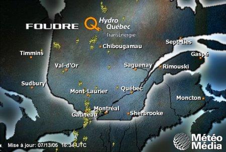
J'avoue moi aussi en regardant la carte foudre on dirait que ca remonte par ici mais la question est est-ce que cette ligne va maintenir cette direction?
-
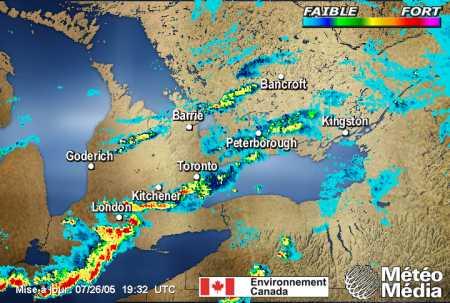
Petite question :Est-ce que l'action qui est en ce moment du coté de lontario va se déplacer au québec ou va passer au sud?...Voici l'alerte d'orage violent pour l'ontario... EMISE PAR ENVIRONNEMENT CANADA A 16H14 HAE LE MARDI 26 JUILLET 2005. ALERTE D'ORAGES VIOLENTS POUR: =NOUVEAU= ST. CATHARINES - GRIMSBY - REGION DE NIAGARA NORD LONDON - PARKHILL - COMTE DE MIDDLESEX EST SIMCOE - DELHI - NORFOLK DUNNVILLE - CALEDONIA - HALDIMAND WOODSTOCK - TILLSONBURG - COMTE D'OXFORD BRANTFORD - COMTE DE BRANT VILLE DE HAMILTON BURLINGTON - OAKVILLE KITCHENER - CAMBRIDGE - REGION DE WATERLOO. ALERTE D'ORAGES VIOLENTS TERMINEE POUR: WINDSOR - LEAMINGTON - COMTE D'ESSEX CHATHAM-KENT - PARC RONDEAU RODNEY - SHEDDEN - COMTE D'ELGIN OUEST ST. THOMAS - AYLMER - COMTE D'ELGIN EST STRATHROY - KOMOKA - COMTE DE MIDDLESEX OUEST STRATFORD - MITCHELL - COMTE DE PERTH SUD. ==DESCRIPTION== A 16H10 LE RADAR MONTRAIT UNE LIGNE D'ORAGES VIOLENTS DE GRIMSBY A BRANTFORD AU NORD-OUEST DE WOODSTOCK SE DEPLACANT VERS L'EST A ENVIRON 60 KM/H. DES VENTS DESTRUCTEURS A 100 KM/H DES ECLAIRS INTENSES DE LA GROSSE GRELE ET DES PLUIES TORRENTIELLES SONT POSSIBLES. LE RADAR A AUSSI MONTRE UNE ROTATION AVEC QUELQUES ORAGES. UNE TORNADE EST AUSSI POSSIBLE. CECI EST UN AVERTISSEMENT INDIQUANT QUE DES ORAGES VIOLENTS SONT SUR LE POINT D'AFFECTER OU AFFECTENT DEJA CES REGIONS. RAPPEL...CERTAINS ORAGES VIOLENTS PRODUISENT DES TORNADES..SURVEILLEZ LES MISES A JOUR D'AVERTISSEMENTS. LE BUREAU DES MESURES D'URGENCE DE L'ONTARIO RECOMMANDE DE VOUS METTRE A L'ABRI IMMEDIATEMENT A L'APPROCHE DU TEMPS VIOLENT. NOTE..UN RESUME DE TOUS LES AVERTISSEMENTS ET VEILLES POUR LE SUD DE L'ONTARIO EST DISPONIBLE DANS LE BULLETIN WWCN71 CWTO EMIS IMMEDIATEMENT APRES CE BULLETIN
-
t-k si on a rien ici nos voissin de l'ontario eux son choyer regarder limage radar!
-
Ca commence a se dévelloper dans l'extreme sud de l'ontario...quelques alertes d'orage violent
-
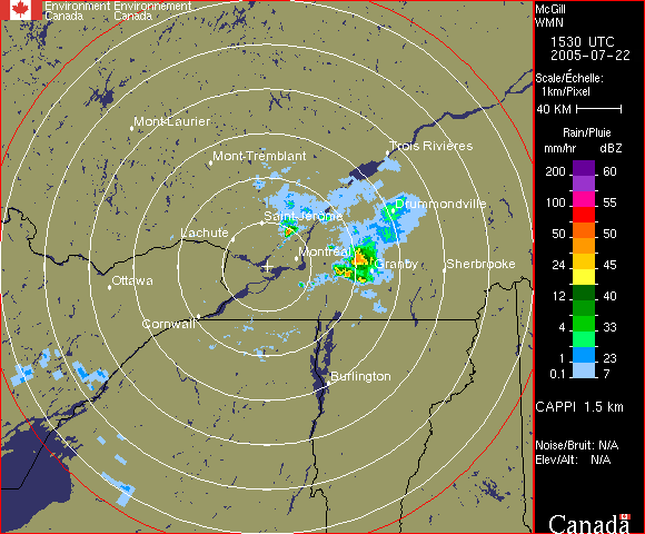
Wais ici a Granby meme chose pluie tres forte pendant 15 minutes environ...tres peu d'éclairs avec cette cellule bien que j'entendais quelque coups de tonerre...Des bons vents également...en tout cas autres cellules tres probables cette apres-midi avec p-e quelques orages violen on se croisent les doigts
-
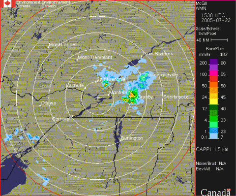
Youpi le radar montre la bonne cellulle au nord-ouest de granby et le tout se déplace sud ouest!!!
-
J'ai rien dit en quelque minute la pluie forte s'est mit de la parite ainsi que kelke coup de tonnere
-
Il y a alerte dans mon secteur mais pour linstant je ne trouve pas que ca pete...t-k une possibilité de torrnade pour la région du richelieu-yamaska et pour la partie ouest de l'estrie...Voici lalerte... Avertissements météo officiels d'Environnement Canada Alertes/avertissements secteur de Granby - Waterloo 10h56 HAE le vendredi 22 juillet 2005 une alerte d'orages violents pour secteur de Granby - Waterloo est emise Des orages dans le long du Richelieu, de St-Jean à st-denis, se déplace vers est à 40 km/h. Ces orages produiront des rafales de 90 km/h ou plus - de la grêle de 2 cm ou plus - de fortes pluies - et De nombreux éclairs. ===attention ces orages sont particulièrement forts et pourraient causer une TORNADE===
-

le 21, dernier potentiel avant logtemps!
meteomarc a répondu à un(e) topic de Rockabill dans Discussions générales
j'espere pour les orages le 21 ca serait un beau cadeau de fete(eh oui c ma fete le 21)...Mais d'apres moi le potentiel orageux serait plus présent vendredi avec le passage d'un front froid...je me trompe? -
Moi ce matin vers 12h00 jétais sur la 10 a la hauteur de marieville...orage fort avec beaucoup d'éclair et de la pluie tres intense on a été obliger d'arreter sur le bord de lautoroute car on ne voyait plus rien tellement le pare-brise était plein d'eau...t-k c pas mal tout...
-
Potentiel orageux à surveiller
meteomarc a répondu à un(e) topic de Patito dans Discussions générales
Effectivement le rique est bien présent pour demain mardi...mais aujourd'hui, lundi, les orages de masses d'air sont assez probables, surtout pour l'axe Saguenay-Québec-Estrie...Ce risque d'orage est présent jusqu'au coucher du soleil...ensuite une zone d'accalmie jusqu'a larrivée du front froid demain matin...Le rique pour mardi est plus élevé car en plus du front froid l'humidité et la chaleur seront birn présents partout dans le sud et le centre du Québec...Espérons que ca va brasser -
Bye Bye Dennis...Bonjour Emily!
meteomarc a répondu à un(e) topic de Hurry dans Discussions générales
Vendredi a 8pm...Emily a des vents de 155mph!!!Le seuil de catégorie 5 est de 156!!!!!...en plus, dans les 24 prochaines heures(avant d'atteindre la péninsule du yucatan), Emily sera dans un environnement favorable pour le dévellopement...elle devrait rester comme elle est présentement ou meme augmenter de force!!! A HURRICANE WARNING REMAINS IN EFFECT FOR JAMAICA AND FOR ALL OF THE CAYMAN ISLANDS. A HURRICANE WATCH IS IN EFFECT FOR THE EASTERN AND NORTHERN COASTS OF THE YUCATAN PENINSULA FROM CHETUMAL TO PROGRESSO...INCLUDING COZUMEL AND THE ISLAS MUJERES. A TROPICAL STORM WATCH REMAINS IN EFFECT FOR THE COAST OF BELIZE FROM BELIZE CITY NORTHWARD TO THE BELIZE-MEXICO BORDER. A TROPICAL STORM WATCH MAY BE REQUIRED FOR PORTIONS OF WESTERN CUBA LATER SATURDAY EVENING. As of 8:00 p.m. EDT Saturday, Hurricane Emily was centered at 17.1 north and 79.5 west, or about 195 miles southeast of Grand Cayman. The minimum central pressure has lowered to 929 millibars (27.43 inches). Maximum sustained winds are 155 mph with higher gusts. Movement is west-northwest at 18 mph. Emily should stay in a mostly favorable environment for the next 24 hours before moving over land. This will keep Emily a dangerous hurricane until landfall on the Yucatan Peninsula. Average surface pressures in the area remain low, and water temperatures remain high. Emily is expected to continue to fluctuate in intensity, especially if undergoing any eyewall replacement cycles. Emily will move away from the southwest coast of Jamaica Saturday evening on a west-northwest track. She will make landfall on the Yucatan Peninsula Sunday night although conditions will dramatically worsen during the day Sunday. Emily may pose a threat to the northern or central Mexican coast sometime Tuesday or Wednesday of next week. There is still a chance that Emily could track a little farther north, which would put South Texas at greater risk. A tropical wave about 750 miles east-northeast of the northern Leeward Islands remains poorly organized Saturday afternoon. The wave will have to be watched for development, even though the upper-level winds are not entirely favorable. -
Bye Bye Dennis...Bonjour Emily!
meteomarc a répondu à un(e) topic de Hurry dans Discussions générales
Déja catégorie 4!!!...Les experts prévoyaient ca pour la journée de samedi et déja vendredi matin Emily est catégorie 4!!!...Je c pas si je suis dans le champs...mais tant qu'a moi c'est possible que Emily atteigne la catégorie 5 car il reste encore bcp de chemin dans les eaux chaudes avant que l'ouragan atteingne la péninsule du Yucatan ou elle fera bcp de dommage...t-k 20 mph de plus et la catégorie 5 est atteinte... Hurricane Emily Remains a Category 4 Storm.. A HURRICANE WARNING IS IN EFFECT FOR ALL OF JAMAICA. A HURRICANE WARNING MEANS THAT HURRICANE CONDITIONS ARE EXPECTED WITHIN THE WARNING AREA WITHIN THE NEXT 24 HOURS. PREPARATIONS TO PROTECT LIFE AND PROPERTY SHOULD BE RUSHED TO COMPLETION. A HURRICANE WATCH REMAINS IN EFFECT FOR ALL OF THE CAYMAN ISLANDS. A TROPICAL STORM WARNING IS IN EFFECT FOR PORTIONS OF THE SOUTHERN COAST OF THE DOMINICAN REPUBLIC FROM PUNTA SALINAS WESTWARD TO THE DOMINICAN REPUBLIC/HAITI BORDER...AND FOR THE ENTIRE SOUTHWESTERN PENINSULA OF HAITI FROM THE DOMINICAN REPUBLIC/HAITI BORDER TO PORT-AU-PRINCE. AT 8 AM AST...1200 UTC...THE TROPICAL STORM WARNING FOR VENEZUELA AND FOR BONAIRE...CURACAO...AND ARUBA HAS BEEN DISCONTINUED. As of 8 a.m. EDT, Hurricane Emily was centered at 14.1 north, 70.0 west, or about 525 miles east-southeast of Kingston, Jamaica. The estimated minimum central pressure is 952 millibars (28.11 inches). Maximum sustained winds are 135 mph with higher gusts. Emily is a dangerous category 4 hurricane and is moving toward the west-northwest at 20 mph. Emily should stay in a mostly favorable environment for the next couple of days, one that will maintain its intensity. Shear remains low, average surface pressures in the area remain low, and water temperatures remain high. Emily will take a track south of Hispaniola today, and is on a course that will take it close to or just south of Jamaica tomorrow morning. Emily will make landfall on the Yucatan Peninsula Sunday afternoon or Sunday night. Emily may pose a threat to the Mexican coast or even the South Texas Coast sometime Tuesday or Wednesday of next week. A tropical wave is in the middle of the Atlantic, along 42 west, south of 22 north, with a 1011 millibar low along the wave axis, near 16 north. This system seems be better organized, in comparison to 24 hours ago, and will be watched for development, even though the upper-level winds are not entirely favorable. A tropical wave is in the far eastern Atlantic, along 24 west, south of 19 north, moving west. There is no strong convection, or thunderstorm activity, associated with this wave. There is a tropical wave along 51 west, south of 12 north. This system is in between Emily, and the well-organized wave in the central Atlantic, and is not likely to develop. -
Bye Bye Dennis...Bonjour Emily!
meteomarc a répondu à un(e) topic de Hurry dans Discussions générales
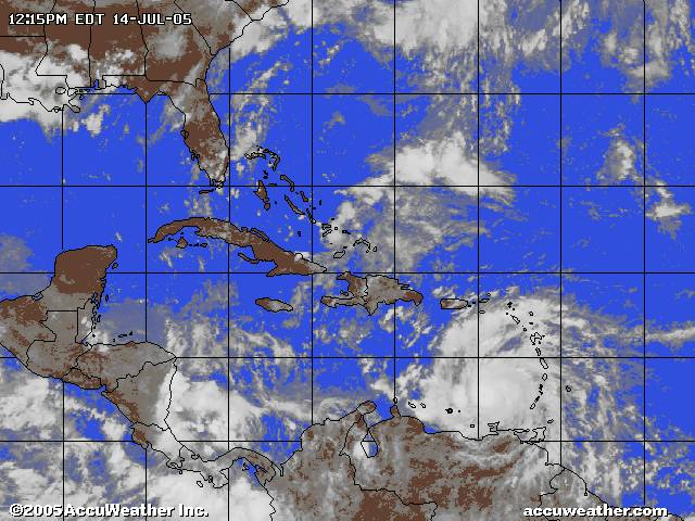
Et voila Emily est catégorie 3!!!...elle pourrait facilement passer la catégorie 4 avvant datteindre la péninsule du yucatan! Hurricane Emily in the southeastern Caribbean A HURRICANE WATCH IS IN EFFECT FOR JAMAICA. A TROPICAL STORM WARNING IS IN EFFECT FROM PUNTA SALINAS WESTWARD TO THE DOMINICAN REPUBLIC/HAITI BORDER. A TROPICAL STORM WARNING IS IN EFFECT THE DOMINICAN REPUBLIC/HAITI BORDER TO PORT-AU-PRINCE. A TROPICAL STORM WARNING IS IN EFFECT FOR THE NORTHERN COAST OF VENEZUELA FROM PEDERNALES WESTWARD TO PUNTO FIJO... INCLUDING ISLA MARGARITA AND THE OFFSHORE ISLANDS NORTH OF THE COAST AND WEST OF CUMANA. A TROPICAL STORM WARNING IS IN EFFECT FOR BONAIRE... CURACAO... AND ARUBA. As of 8 p.m. EDT, Hurricane Emily was centered at 13.3 north, 66.7 west, or about 415 miles south-southeast of Santo Domingo in the Dominican Republic. The central pressure measured by a United States air force reconnaissance aircraft is 962 millibars (28.41 inches). Maximum sustained winds remain near 115 mph with higher gusts. Emily is a dangerous category 3 hurricane and is moving to the west-northwest at 20 mph. Emily is moving into, and should stay, in a mostly favorable environment for intensification. Shear remains low, average surface pressures in the area remain low and water temperatures remain high. We believe that Emily will track across the southeastern Caribbean and continue to intensify, as it moves away from the northern part of South America. Emily should take a track south of Hispaniola tomorrow and tomorrow night and is on a course that will take it close to or just south of Jamaica Saturday morning. Emily has the potential to become a Category 4 hurricane on its way toward the Yucatan Peninsula. Emily may pose a threat to the Mexican coast or even south Texas Coast sometime Tuesday or Wednesday of next week. A tropical wave is along 41 west, south of 21 north; a 1012 millibar low is along the wave axis, near 15 north. Fairly strong convection, or thunderstorms, are occurring mainly north of the low pressure area. This system is moving west and will be watched for strengthening. Elsewhere in the Atlantic, there is a tropical wave near the African coast along 24 west, south of 19 west -
situation orageuse pour le 14 Juillet
meteomarc a répondu à un(e) topic de castor028 dans Discussions générales
J'étais a Granby tantot et j'étais sur un terrain de soccer et je voila tres bien la grosse cellule ki passait juste a l'est...quelque bons éclairs dont une ki a allumer un feux a kelkes kilometres de ou jétais...je suis pas sur mais je crois que j'ai vu un nuage ki ressemblait bcp a un mésocyclone...mon pere lui roulait sur la 10 je crois et lui aussi a cru voir quelque choz de tel...autre fait a noter...de la pluie tres tres tres forte...une des plus grosses averses que j'ai vu de ma vie...ca tombait vraiment dru et des grosses gouttes... -
situation orageuse pour le 14 Juillet
meteomarc a répondu à un(e) topic de castor028 dans Discussions générales
Oups voici l'Alerte... secteur de Saint-Hyacinthe - Acton Vale 14h32 HAE le jeudi 14 juillet 2005 une alerte d'orages violents pour secteur de Saint-Hyacinthe - Acton Vale est emise Une cellule orageuse près de st-guillaume se dirige vers le sud-sud-est à 40 km/h. Ces orages produiront des rafales de 90 km/h ou plus - de la grêle de 2 cm ou plus - de fortes pluies - et de nombreux éclairs. Génial cette cellule va passer pres de chez moi(Granby)surtout si elle s'intensifie et ca ca reste a voir...pour l'instant tout le sud est sous veille...on verra! -
situation orageuse pour le 14 Juillet
meteomarc a répondu à un(e) topic de castor028 dans Discussions générales
Alerte d'orage violent pour drummondille acton vale st-hyacinthe...Ca se dirige vers le sud sud est...ca va passer pres de mon secteur(granby)... -
Bye Bye Dennis...Bonjour Emily!
meteomarc a répondu à un(e) topic de Hurry dans Discussions générales
Emily maintenant ouragan de catégorie 2...un autre ouragan qui pourrait devenir majeur!!! Hurricane Emily in the southeastern Caribbean AT 11 A.M. AST... 1200Z... AT 11 AM AST... 1500Z... THE GOVERNMENT OF THE DOMINICAN REPUBLIC HAS ISSUED A TROPICAL STORM WATCH FROM PUNTA SALINAS WESTWARD TO THE DOMINICAN REPUBLIC/HAITI BORDER. THE GOVERNMENT OF HAITI HAS ISSUED A TROPICAL STORM WATCH FROM THE DOMINICAN REPUBLIC/HAITI BORDER TO PORT-AU-PRINCE. AT 11 AM AST... THE GOVERNMENT OF TRINIDAD HAS DISCONTINUED THE TROPICAL STORM WARNING FOR GRENADA AND ITS DEPENDENCIES. A TROPICAL STORM WARNING IS IN EFFECT FOR THE NORTHERN COAST OF VENEZUELA FROM PEDERNALES WESTWARD TO PUNTO FIJO... INCLUDING ISLA MARGARITA AND THE OFFSHORE ISLANDS NORTH OF THE COAST AND WEST OF CUMANA. A TROPICAL STORM WARNING IS IN EFFECT FOR BONAIRE... CURACAO... AND ARUBA. As of 11 a.m. EDT, Hurricane Emily was centered at 12.7 north, 64.0 west, or about 560 miles southeast of Santo Domingo in the Dominican Republic. The estimated central pressure is 976 millibars (28.82 inches). Maximum sustained winds are estimated at 100 mph with higher gusts. Emily is now a category 2 hurricane and is moving toward the west-northwest at 18 mph. Emily is moving into, and should stay, in a mostly favorable environment for intensification. Shear remains low, average surface pressures in the area remain low and water temperatures remain high. We believe that Emily will track across the southeastern Caribbean and continue to intensify, as it moves away from the northern part of South America. Emily should take a track south of Hispaniola tomorrow and tomorrow night and is on a course that will take it close to or just south of Jamaica Saturday and Saturday night. Emily could become a Category 3 (major) hurricane this weekend on its way toward the Yucatan Peninsula. Emily may pose a threat to the south Texas Coast sometime during the middle of next week. A tropical wave is along 40 west, south of 21 north; a 1011 millibar low is along the wave axis, near 15 north. Fairly strong convection, or thunderstorms, are occurring mainly north of the low pressure area. This system is moving west and will be watched for strengthening. Elsewhere in the Atlantic, there is a tropical wave near the African coast along 22 west, south of 19 west. A weak tropical wave is along 47 west, south of 17 north. A tropical wave is over the Yucatan, along 92 west, south of 19 north, moving into the eastern Pacific. Regardez la structure nuageuse...déja assez imposante Emily!
-
Ici a Granby il a fait chaud et humide toute l'apres-midi la température dépassait le 30 degré...il faisait soleil...je crois donc plus que possible le développement d'orage dans ma région...qu'en pensez vous?
-
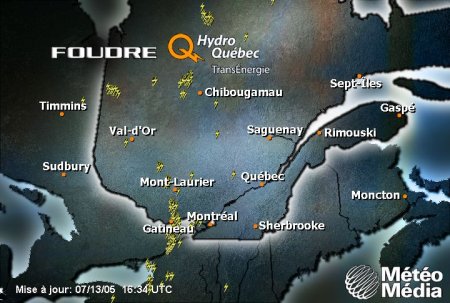
Bonne ligne pres de gatineau
-
Bye Bye Dennis...Bonjour Emily!
meteomarc a répondu à un(e) topic de Hurry dans Discussions générales
Tropical Storm Emily approaching the Lesser Antilles.. A HURRICANE WARNING IS IN EFFECT FOR TOBAGO...GRENADA... THE GRENADINES...ST. VINCENT...AND ST. LUCIA. A TROPICAL STORM WARNING AND A HURRICANE WATCH ARE IN EFFECT FOR TRINIDAD. A TROPICAL STORM WARNING IS IN EFFECT FOR BARBADOS. A TROPICAL STORM WARNING IS ALSO IN EFFECT FOR A PORTION OF THE NORTHERN COAST OF VENEZUELA...FROM PEDERNALES WESTWARD TO CUMANA...INCLUDING ISLA MARGARITA. A TROPICAL STORM WATCH IS IN EFFECT FOR MARTINIQUE. Tropical Storm Emily, as of 8 a.m. EDT, was centered at 11.3 north, 57.2 west, or about 200 miles southeast of Barbados in the Lesser Antilles. The estimated central pressure is 997 millibars (29.44 inches). Maximum sustained winds are estimated at 60 mph with gusts to 70 mph. It is moving toward the west at 20 mph and is expected to turn slight north of west during the next 24 hours. Once Emily moves closer to the Lesser Antilles, it will be in a more favorable environment. Shear remains low, average surface pressures in the area remain low and water temperatures remain high. So, all the necessary ingredients for intensification are in place. We believe that Emily will track across the Lesser Antilles early tonight, and strengthen to hurricane status in the eastern Caribbean late tonight. It should take a track to the south of Hispaniola Friday and Friday night and is on a course that will take it south of Jamaica Saturday and Saturday night. Emily has the potential to strengthen into a Category 3 hurricane, especially when it gets into the western Caribbean, well away from the South American coastline. Over the next couple of days, how much the storm intensifies will be determined by how close it tracks to Tobago, Trinidad, and the coast of South of America. Obviously, interaction with land would disrupt the intensification process. The large high pressure area over northern Florida is stronger now than what it was when Dennis was moving into the Gulf. So, it could be that this Atlantic ridge will be strong enough to guide Emily more westward, toward the Yucatan and even Central America. A tropical wave in the eastern Atlantic, along 33 west, south of 17 north, features a surface low near or just south of 15 north. This wave has a large envelope of clouds extending northward. This wave resembles the cloud pattern that Dennis had when it was in this same area, will certainly be watched for intensification. Elsewhere in the Tropical Atlantic, a tropical wave along 40 west, south of 16 north has weakened since it is so close to Emily's circulation. So, it is doubtful that this feature will organize anytime soon. The tropical wave in the westernmost Caribbean is along 85 west, south of 18 north, moving westward into Central America. -
Bye Bye Dennis...Bonjour Emily!
meteomarc a répondu à un(e) topic de Hurry dans Discussions générales
Article de AW Tropical Storm Emily, now in the west-central Atlantic, is taking aim on the Windward Islands. It continues to gather strength, and this trend should continue through Wednesday. Upper-level winds are fairly light and are generally from west to east in the area where Emily is headed. This means that there is only weak shear; a favorable situation for any tropical system. Emily is expected to be nearing hurricane strength by the time it reaches the Windward Islands later Wednesday, and with overall conditions still quite favorable, Emily could be a major hurricane by the time it reaches the central Caribbean. should remain in a fairly westerly course the next couple of days as an area of high pressure in the upper levels of the atmosphere will remain to its north. This will keep winds at the steering level blowing from east to west. Emily should roar across the central Lesser Antilles late Wednesday and then head into the eastern Caribbean Thursday.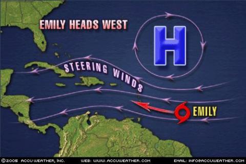
-
Bye Bye Dennis...Bonjour Emily!
meteomarc a répondu à un(e) topic de Hurry dans Discussions générales
J'ai pris ça sur AW...potentiel pour Emily de devenir un Ouragan cette semaine... Hurricane Summary POSTED: July 11, 2005 10:45 p.m. Tropical Storm Emily forms in the central Atlantic and may become a hurricane later in the week. -
Bye Bye Dennis...Bonjour Emily!
meteomarc a répondu à un(e) topic de Hurry dans Discussions générales
Voila, a 11 pm Émily est officielement nommée...La Tempete tropical Émily génère en ce moment des vents de 45 mph...C'est étonnant que cette dépression aille déja passer le seuil de tempete tropical...A 8 heures ce matin, les experts prévoyaient qu'elle passerait le cap de tempete tropicale dans 24 a 48 heures...environ 14 heures plus tard c'est une tempete tropicale... -
chaleur extrêmes dans le Nord-Ouest du Québec
meteomarc a répondu à un(e) topic de Rockabill dans Discussions générales
29,4 a kuujjuarapik était le record pour un 11 juillet...ce n'était pas le record absolu...d'ailleurs est-ce que quelqun a le vrai record absolu pour kuujuarapik?