Regg001 Posté(e) le 10 juin 2008 Signaler Partager Posté(e) le 10 juin 2008 Avis au chasseurs je suis disponible pour un nowcast dès 14h Comment ça t'es pas en route toi ? Lien vers le commentaire Share on other sites More sharing options...
Jean-Seb Posté(e) le 10 juin 2008 Signaler Partager Posté(e) le 10 juin 2008 Hey enfin de la bonne action à suivre !! J'espere juste que l'anti biorage ne va pas défaire tout sa :P Présentement à saint-eustache ciel voilée ! Ca gonfle pas mal au nord en tout cas! Lien vers le commentaire Share on other sites More sharing options...
dann17 Posté(e) le 10 juin 2008 Signaler Partager Posté(e) le 10 juin 2008 la belle cellule s'en vient pile poil sur vous à Montréal gang de chanceux ! Vers 14h15-14h20, ça devrait secouer en effet... il est possible que, contrairement à "l'anti-biorage", l'effet urbain augmente en fait l'impulsion ascendante : pour ce faire, il faudrait que la vitesse d'avancement de cette cellule ne soit pas trop grande... Lien vers le commentaire Share on other sites More sharing options...
Rockabill Posté(e) le 10 juin 2008 Signaler Partager Posté(e) le 10 juin 2008 commentaires de Brett Anderson,, c'est rare qui parle de severe weather pour le Québec Bernie Rayno and myself have been looking at the latest surface, upper-air and satellite observations from extreme eastern Ontario and into southern Quebec in regards to the severe thunderstorm threat this afternoon and evening (Tuesday). This looks like a classic setup for damaging thunderstorms across this region and even the possibility of tornadoes. The main area of concern is from the Ottawa/Cornwall region on east and northeast through Montreal and Sherbrooke. Very warm and humid air is now in place across these areas, and with the sun out the atmosphere will become very unstable this afternoon. We also have a vigorous jet stream punching in from the west with cooling aloft. The latest atmospheric sounding data is also showing a a pretty good amount of wind shear (change in wind direction with height) This turning, when combined with a large thunderstorm cell can lead to a rotating cell and even a tornado. As of this writing (11:25 am Tue), Quebec City was still north of the warm front and in the cooler, more stable air, but I think the warm front will lift into that area as well late today, putting that area under the threat of severe weather into the evening. Lien vers le commentaire Share on other sites More sharing options...
eclair14 Posté(e) le 10 juin 2008 Signaler Partager Posté(e) le 10 juin 2008 SEVERE WEATHER STATEMENTNATIONAL WEATHER SERVICE BURLINGTON VT105 PM EDT TUE JUN 10 2008 NYC033-089-101745-/O.CON.KBTV.SV.W.0006.000000T0000Z-080610T1745Z/FRANKLIN NY-ST. LAWRENCE NY-105 PM EDT TUE JUN 10 2008 ...A SEVERE THUNDERSTORM WARNING REMAINS IN EFFECT UNTIL 145 PM EDTFOR NORTHEASTERN ST. LAWRENCE AND FRANKLIN COUNTIES IN NORTHERN NEWYORK... AT 104 PM EDT...NATIONAL WEATHER SERVICE DOPPLER RADAR CONTINUED TOINDICATE A SEVERE THUNDERSTORM CAPABLE OF PRODUCING NICKEL SIZEHAIL...AND DESTRUCTIVE WINDS IN EXCESS OF 80 MPH. THIS STORM WASLOCATED NEAR LAWRENCEVILLE..MOVING NORTHEAST AT 53 MPH. THE SEVERE THUNDERSTORM WILL BE NEAR... DICKINSON AND MOIRA AROUND 110 PM EDT. BRUSHTON...WEST BANGOR AND BANGOR AROUND 115 PM EDT. NORTH BANGOR AND BANGOR AROUND 120 PM EDT. MALONE AND WESTVILLE CENTER AROUND 125 PM EDT. CONSTABLE AROUND 130 PM EDT. A TORNADO WATCH REMAINS IN EFFECT FOR THE WARNED AREA. IF A TORNADOIS SPOTTED... ACT QUICKLY AND MOVE TO A PLACE OF SAFETY IN A STURDYSTRUCTURE...SUCH AS A BASEMENT OR SMALL INTERIOR ROOM. THIS STORM CREATED WIDESPREAD WIND DAMAGE IN RUSSELL NEW YORK AT1235 PM. A WIND GUST OF 58 MPH WAS REPORTED IN POTSDAM NEW YORK AT100 PM. Lien vers le commentaire Share on other sites More sharing options...
eclair14 Posté(e) le 10 juin 2008 Signaler Partager Posté(e) le 10 juin 2008 ALERTE ORAGE VIOLENT SUR MONTRÉAL ! Lien vers le commentaire Share on other sites More sharing options...
Regg001 Posté(e) le 10 juin 2008 Signaler Partager Posté(e) le 10 juin 2008 ALERTE ORAGE VIOLENT SUR MONTRÉAL ! J'espère que ça te surprend pas là ça fait 4 heures qu'on en parle ha ha . Lien vers le commentaire Share on other sites More sharing options...
MThd Posté(e) le 10 juin 2008 Signaler Partager Posté(e) le 10 juin 2008 ALERTE ORAGE VIOLENT SUR MONTRÉAL ! J'espère que ça te surprend pas là ça fait 4 heures qu'on en parle ha ha . Haha on s'était quand même habitué à ce que tout s'effondre mystérieusement juste avant d'entrer à Montréal! ;-P Lien vers le commentaire Share on other sites More sharing options...
Rockabill Posté(e) le 10 juin 2008 Signaler Partager Posté(e) le 10 juin 2008 Ça pas lair à se reformer fort après la ligne qui s,en vient Lien vers le commentaire Share on other sites More sharing options...
dave20 Posté(e) le 10 juin 2008 Signaler Partager Posté(e) le 10 juin 2008 (modifié) Ça pas lair à se reformer fort après la ligne qui s,en vient Regarde le satellite.. on voit que sa travail.. ya des lignes qui se forment présentement Modifié le 10 juin 2008 par dave20 Lien vers le commentaire Share on other sites More sharing options...
marcrem Posté(e) le 10 juin 2008 Signaler Partager Posté(e) le 10 juin 2008 ce n'est pas mystérieux du tout, cet effondrement que subit souvent montréal. J'ai bien hate de voir l'évolution des choses... rien de si excitant pour le moment.. Regg, je ne pourrai pas chasser aujourd'hui finalement. Lien vers le commentaire Share on other sites More sharing options...
Bouli-nachos Posté(e) le 10 juin 2008 Signaler Partager Posté(e) le 10 juin 2008 (modifié) Est-c que qq1 peut me now caster.... mp svp! merci Si qq1 d'aimable..svp m'apeller 514 802 1629 je pars... Modifié le 10 juin 2008 par Bouli-nachos Lien vers le commentaire Share on other sites More sharing options...
eclair14 Posté(e) le 10 juin 2008 Signaler Partager Posté(e) le 10 juin 2008 Situation en ce moment Lien vers le commentaire Share on other sites More sharing options...
marcrem Posté(e) le 10 juin 2008 Signaler Partager Posté(e) le 10 juin 2008 Situation en ce moment le front froid est encore plus loin que ça à l'ouest Lien vers le commentaire Share on other sites More sharing options...
dave20 Posté(e) le 10 juin 2008 Signaler Partager Posté(e) le 10 juin 2008 Situation en ce moment Pour le front froid c'est exactement ça ! Lien vers le commentaire Share on other sites More sharing options...
Gypso Posté(e) le 10 juin 2008 Signaler Partager Posté(e) le 10 juin 2008 Allo À quoi peut-on s'attendre pour Québec ? Merci ! Lien vers le commentaire Share on other sites More sharing options...
dave20 Posté(e) le 10 juin 2008 Signaler Partager Posté(e) le 10 juin 2008 Sherbrooke.. il y a une bonne cellule qui s'en vient, dans la prochaine demi-heure ! Lien vers le commentaire Share on other sites More sharing options...
eclair14 Posté(e) le 10 juin 2008 Signaler Partager Posté(e) le 10 juin 2008 Le front évolue beaucoup moin rapidement que prévu, il atteindra Montréal seulement en mi-soirée et Québec en début de nuit Lien vers le commentaire Share on other sites More sharing options...
Ahzuz Posté(e) le 10 juin 2008 Signaler Partager Posté(e) le 10 juin 2008 Sherbrooke.. il y a une bonne cellule qui s'en vient, dans la prochaine demi-heure ! on a eu de la bonne grêle et de très fort vent pour 15minutes... c'était assé violent mais aucun dommage apparent.. tant mieux. Lien vers le commentaire Share on other sites More sharing options...
Bouli-nachos Posté(e) le 10 juin 2008 Signaler Partager Posté(e) le 10 juin 2008 Finalement la 1ere bande aura eu raison du front froid...comme je le pensais ce matin Lien vers le commentaire Share on other sites More sharing options...
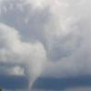
dom Posté(e) le 10 juin 2008 Signaler Partager Posté(e) le 10 juin 2008 Je ne sais pas si elle en eu raison mais le NEXRAD du nord de l'état de New York vient d'identifier un ''Tornado Vortex Signature'' en direction de Burlington!!! Lien vers le commentaire Share on other sites More sharing options...
dom Posté(e) le 10 juin 2008 Signaler Partager Posté(e) le 10 juin 2008 Je ne sais pas si c'est moi qui capote mais je ne vois aucun avertissement ou alerte au Nouveau-Brunswick. Il y a la ligne qui nous a passé aujourd'hui qui se dirige au NB avec des tops echo de 40,000 ft. Aucun avertissement en vigueur au NB, ni alerte... Environnement Canda attend quoi?!? Lien vers le commentaire Share on other sites More sharing options...
shawn_strat Posté(e) le 10 juin 2008 Signaler Partager Posté(e) le 10 juin 2008 (modifié) Je pense que oui. Je pense par contre, que les Laurentides vont en gouter ce fois ci. Alors la rive sud en premier, le nord après, et moi, rien, c'est platte ma fete aujourd'hui... Modifié le 10 juin 2008 par shawn_strat Lien vers le commentaire Share on other sites More sharing options...
uranium Posté(e) le 10 juin 2008 Signaler Partager Posté(e) le 10 juin 2008 (modifié) Je ne sais pas si c'est moi qui capote mais je ne vois aucun avertissement ou alerte au Nouveau-Brunswick. Il y a la ligne qui nous a passé aujourd'hui qui se dirige au NB avec des tops echo de 40,000 ft. Aucun avertissement en vigueur au NB, ni alerte... Environnement Canda attend quoi?!? Effectivement, il y a une ou deux cellules avec un top dans les 43 000 pieds. Globalement, cela se situe entre 33 000 et 36 000 pieds. Modifié le 10 juin 2008 par uranium Lien vers le commentaire Share on other sites More sharing options...
uranium Posté(e) le 10 juin 2008 Signaler Partager Posté(e) le 10 juin 2008 Peut-être que cela a déjà été '' posté '', voici un bilan : Sommaire des évènements météorologiques significatifsPour le Québec émis par Environnement Canada MontréalÀ 17h00 HAE le mardi 10 juin 2008. ...Temps violent sur le Québec... Le passage d'une ligne d'orages forts en après-midi surLe sud du Québec a généré plusieurs évènements météorologiques violents. Grêle, pluie torrentielle, rafales de vent supérieuresÀ 90 km/h, le temps s'est dechaine. La présence d'une masse d'air très chaude et humide sur le Québec a contribué à la formationDe puissants orages. Des le matin des avertissements d'orages violents ont été émis par le centre de prévision des intemperies d'Environnement Canada. Voici un premier bilan des évènementsMétéorologiques violents qui ont été observés jusqu'à 17h00. Localité......Évènement(s)......... Heure (lcl) Elgin rafale de 90 km/h 13h30 HAESt-Hubert rafale de 111 km/h 14h24 HAELongueuil grêle de 2 cm 14h30 HAEMont st-hilaire grêle de 5-6 cm 14h30 HAEOtterbrun park grêle de 5-6 cm 14h30 HAEFrelighsburg rafale de 90 km/h 14h35Trois-Rivières rafale de 110 km/h 15h30 HAENicolet rafale de 100 km/h 15h30 HAESherbrooke rafale de 96 km/h 15h42 HAERive sud de Québec rafale de 100 km/h 17h00 HAE Veuillez noter que ce résumé reflète les observations disponibles au moment de la diffusion mais ne constitue pas un rapport officiel et définitif des évènements météorologiques. Lien vers le commentaire Share on other sites More sharing options...

Recommended Posts