Classement


Contenu populaire
Affichage du contenu avec la meilleure réputation le 2020-11-03 dans toutes les zones
-
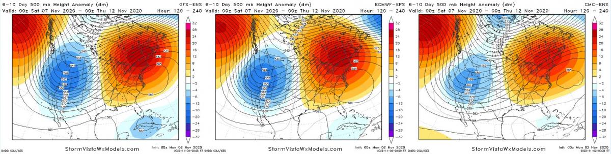
Et que dire de la possible durée de vie d'Éta avec ce fort blocage de l'Atlantique..... On va l'avoir dans les pattes bien longtemps.
 2 points
 -
Pauvre gens, des petits villages pas d'endroit pour se réfugier et une seule route pour y accéder. Espérons un miracle pour cette nuit.
 2 points
 -
tu as raison on est a un cat 4 ! ...ETA BECOMES A CATEGORY 4 HURRICANE AS CONDITIONS BEGIN TO DETERIORATE ALONG THE NORTHEASTERN COAST OF NICARAGUA... ...LIFE-THREATENING STORM SURGE, CATASTROPHIC WINDS, FLASH FLOODING, AND LANDSLIDES EXPECTED ACROSS PORTIONS OF CENTRAL AMERICA... A Hurricane Warning continues for the coast of Nicaragua from the Honduras / Nicaragua border to Sandy Bay Sirpi. Catastrophic wind damage is expected where Eta's eyewall moves onshore within the Hurricane Warning area beginning tonight, with tropical storm conditions beginning within the next few hours. Preparations to protect life and property should be rushed to completion. A Tropical Storm Warning and Hurricane Watch continues for the northeastern coast of Honduras from Punta Patuca to the Honduras / Nicaragua border. Tropical storm conditions are expected there tonight, with hurricane conditions possible in by early Tuesday. A Tropical Storm Watch is in effect for the northern coast of Honduras from west of Punta Patuca westward to Punta Castilla. Tropical Storm conditions are possible there by early Tuesday. A dangerous storm surge will raise water levels by as much as 12 to 18 feet above normal tide levels in areas of onshore winds along the coast of Nicaragua within the hurricane warning area, and 3 to 5 feet above normal tide levels along the coast of Honduras within the tropical storm warning area. Near the coast, the surge will be accompanied by large and destructive waves. Interests elsewhere in Nicaragua and Honduras should monitor the progress of this system. For storm information specific to your area, please monitor products issued by your national meteorological service. At 4 p.m. EST, the eye of Hurricane Eta was located over the Caribbean Sea about 70 miles (110 km) east-southeast of Cabo Gracias A Dios on the Honduras / Nicaragua border and about 80 miles (130 km) east-northeast of Puerto Cabezas, Nicaragua. Eta is moving toward the west-southwest near 9 mph (15 km/h), and this general motion is expected to continue through early Tuesday. A slower westward or west-northwestward motion is forecast to begin on Tuesday and continue through Thursday. On the forecast track, the center of Eta is expected to make landfall along the coast of Nicaragua within the Hurricane Warning area tonight or early Tuesday. The center of Eta is forecast to move farther inland over northern Nicaragua through Wednesday night, and then move across central portions of Honduras on Thursday. Maximum sustained winds have increased to near 130 mph (215 km/h) with higher gusts - a category 4 hurricane on the Saffir- Simpson Hurricane Wind Scale. Hurricane-force winds extend outward up to 25 miles (35 km) from the center and tropical-storm-force winds extend outward up to 125 miles (205 km). Additional strengthening is forecast to occur until Eta reaches the coast of Nicaragua. Weakening will begin after the system moves inland. Eta is expected to produce the following rainfall amounts through Friday evening: - Much of Nicaragua and Honduras: 15 to 25 inches (380 to 635 mm), isolated amounts of 35 inches (890 mm). - Eastern Guatemala and Belize: 10 to 20 inches (255 to 510 mm), isolated amounts of 25 inches (635 mm). - Portions of Panama and Costa Rica: 10 to 15 inches (255 to 380 mm), isolated amounts of 25 inches (635 mm). - Jamaica and southeast Mexico: 5 to 10 inches (125 to 255 mm), isolated amounts of 15 inches (380 mm) over southern areas. - El Salvador, Southern Haiti, and the Cayman Islands: 3 to 5 inches (75 to 125 mm), isolated amounts of 10 inches (255 mm). This rainfall will lead to catastrophic, life-threatening flash flooding and river flooding, along with landslides in areas of higher terrain of Central America. Flash flooding and river flooding are also possible across Jamaica, southeast Mexico, El Salvador, southern Haiti, and the Cayman Islands. The next complete advisory will be issued by NHC at 10 p.m. EST with an intermediate advisory at 7 p.m. EST - www.hurricanes.gov1 point
-
Rapport mensuel pour le mois de octobre 2020 pour Montréal. Pour la température moyenne est de 8.8°C ce qui le classe au numero 72. Moyenne des 30 dernières années 9.0°C. La moyenne minimale était de 4.4°C ce qui le classe au numero 86. Moyenne des 30 dernières années 4.4°C. La moyenne maximale était de 13.0°C ce qui le classe au numero 75. Moyenne des 30 dernières années 13.4°C. Côté météo: Ce mois d'octobre a été un mois normal pour les températures, mais les précipitations étaient de 19.9 mm au-dessus de la moyenne. Nous n'avons eu que 4 nuits en dessous de 0.0°C. Les 7 derniers jours du mois, l'air plus froid s'est établi et bien sûr senti beaucoup plus froid. La feuille de couleur de l'arbre ce mois-ci était très colorée et a remarqué beaucoup de feuilles rouges, à cause des journées chaudes et ensoleillées et des nuits froides au début du mois. Seule une trace de neige a été observée ce mois-ci. Le numéro 1 est le plus chaud et le 221 est le plus froid. Le vert est normal. Le résultat du classement est basé sur 221 années d'observations (1799-2020). Pour la température. http://montrealsky.com/1 point